Estimated Value: $406,000 - $497,000
3
Beds
3
Baths
2,426
Sq Ft
$191/Sq Ft
Est. Value
About This Home
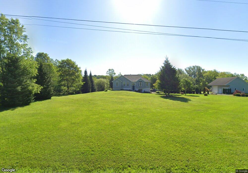
This home is located at 10245 Sampson Rd, Erie, PA 16509 and is currently estimated at $462,780, approximately $190 per square foot. 10245 Sampson Rd is a home located in Erie County with nearby schools including Wattsburg Area Elementary Center, Wattsburg Area Middle School, and Seneca High School.
Ownership History
Date
Name
Owned For
Owner Type
Purchase Details
Closed on
Sep 22, 2006
Sold by
Boley Daniel C and Boley Kim M
Bought by
Cowger Larry E
Current Estimated Value
Home Financials for this Owner
Home Financials are based on the most recent Mortgage that was taken out on this home.
Original Mortgage
$200,000
Outstanding Balance
$119,123
Interest Rate
6.52%
Mortgage Type
Purchase Money Mortgage
Estimated Equity
$343,657
Purchase Details
Closed on
Jun 30, 2005
Sold by
Weston Marshall G and Weston Eileen R
Bought by
Boley Daniel C and Boley Kim M
Home Financials for this Owner
Home Financials are based on the most recent Mortgage that was taken out on this home.
Original Mortgage
$196,000
Interest Rate
5.73%
Mortgage Type
Fannie Mae Freddie Mac
Create a Home Valuation Report for This Property
The Home Valuation Report is an in-depth analysis detailing your home's value as well as a comparison with similar homes in the area
Home Values in the Area
Average Home Value in this Area
Purchase History
| Date | Buyer | Sale Price | Title Company |
|---|---|---|---|
| Cowger Larry E | $252,000 | None Available | |
| Boley Daniel C | $245,000 | -- |
Source: Public Records
Mortgage History
| Date | Status | Borrower | Loan Amount |
|---|---|---|---|
| Open | Cowger Larry E | $200,000 | |
| Previous Owner | Boley Daniel C | $196,000 |
Source: Public Records
Tax History Compared to Growth
Tax History
| Year | Tax Paid | Tax Assessment Tax Assessment Total Assessment is a certain percentage of the fair market value that is determined by local assessors to be the total taxable value of land and additions on the property. | Land | Improvement |
|---|---|---|---|---|
| 2025 | $7,977 | $247,280 | $57,600 | $189,680 |
| 2024 | $7,579 | $247,280 | $57,600 | $189,680 |
| 2023 | $7,234 | $247,280 | $57,600 | $189,680 |
| 2022 | $1,966 | $247,280 | $57,600 | $189,680 |
| 2021 | $6,857 | $247,280 | $57,600 | $189,680 |
| 2020 | $6,795 | $247,280 | $57,600 | $189,680 |
| 2019 | $6,648 | $247,280 | $57,600 | $189,680 |
| 2018 | $6,373 | $247,280 | $57,600 | $189,680 |
| 2017 | $6,101 | $247,280 | $57,600 | $189,680 |
| 2016 | $6,677 | $247,280 | $57,600 | $189,680 |
| 2015 | $6,615 | $247,280 | $57,600 | $189,680 |
| 2014 | $2,881 | $247,280 | $57,600 | $189,680 |
Source: Public Records
Map
Nearby Homes
- 10163 Sampson Rd
- 11328 Donation Rd
- 11221 W Greene Rd
- 11312 Donation Rd
- 9881 Mark Rd
- 9570 Perry Hwy
- 10170 Tiger Lily Ln
- 0 3 Bldg Lots R-2 - Kuhl Rd Unit 173221
- 7000 Turner Rd
- 506 Squirrel Dr
- 9790 Peach St
- 9299 Peach St
- 8991 Kirsch Rd
- 70 Robison Rd W
- 0 Wattsburg Rd Unit 188177
- 684 Benson Rd
- 0 Welsh Clute Rd Unit 180074
- 0 Kuhl Rd Unit 174025
- 7415 Schultz Rd
- 525 Benson Rd
- 10233 Sampson Rd
- 10255 Sampson Rd
- 10210 Sampson Rd
- 10279 Sampson Rd
- 10291 Sampson Rd
- 2952 Brown Rd
- 3130 Brown Rd
- 10314 Sampson Rd
- 2849 Brown Rd
- 10181 Sampson Rd
- 10315 Sampson Rd
- 0 Sampson Rd
- 3131 Brown Rd
- 10322 Sampson Rd
- 3195 Brown Rd
- 10155 Sampson Rd
- 10331 Sampson Rd
- 10335 Sampson Rd
- 10156 Sampson Rd