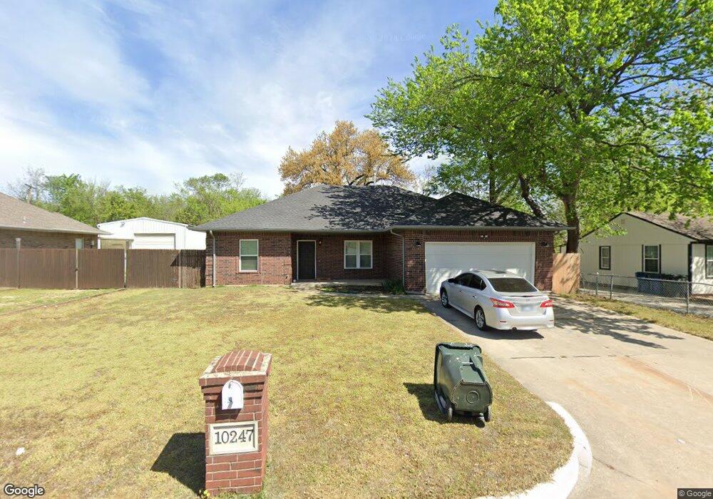
10247 Saint Patrick Dr Oklahoma City, OK 73130
Estimated Value: $231,244 - $249,000
3
Beds
2
Baths
1,634
Sq Ft
$146/Sq Ft
Est. Value
About This Home
This home is located at 10247 Saint Patrick Dr, Oklahoma City, OK 73130 and is currently estimated at $239,311, approximately $146 per square foot. 10247 Saint Patrick Dr is a home located in Oklahoma County with nearby schools including Carl Albert Middle School, Carl Albert High School, and Insight School of Oklahoma High School.
Ownership History
Date
Name
Owned For
Owner Type
Purchase Details
Closed on
Jan 2, 2004
Sold by
Leonard Daniel E and Leonard Cindy A
Bought by
Lewis Ricky G
Current Estimated Value
Purchase Details
Closed on
Aug 28, 2003
Sold by
Smith Ronald L and Smith Brenda
Bought by
Phillips Randy P
Purchase Details
Closed on
Sep 17, 2002
Sold by
King Arnold G and King Corinne K
Bought by
Leonard Daniel E and Leonard Cindy A
Create a Home Valuation Report for This Property
The Home Valuation Report is an in-depth analysis detailing your home's value as well as a comparison with similar homes in the area
Home Values in the Area
Average Home Value in this Area
Purchase History
| Date | Buyer | Sale Price | Title Company |
|---|---|---|---|
| Lewis Ricky G | $131,500 | Stewart Escrow & Title Mwc I | |
| Phillips Randy P | $102,500 | Stewart Escrow & Title Mwc I | |
| Leonard Daniel E | $15,000 | Stewart Escrow & Title |
Source: Public Records
Tax History Compared to Growth
Tax History
| Year | Tax Paid | Tax Assessment Tax Assessment Total Assessment is a certain percentage of the fair market value that is determined by local assessors to be the total taxable value of land and additions on the property. | Land | Improvement |
|---|---|---|---|---|
| 2024 | $2,286 | $20,389 | $2,785 | $17,604 |
| 2023 | $2,286 | $19,418 | $3,053 | $16,365 |
| 2022 | $2,157 | $18,493 | $3,120 | $15,373 |
| 2021 | $2,104 | $17,613 | $2,390 | $15,223 |
| 2020 | $2,059 | $16,775 | $2,792 | $13,983 |
| 2019 | $1,887 | $16,060 | $1,978 | $14,082 |
| 2018 | $1,770 | $16,060 | $0 | $0 |
| 2017 | $1,771 | $15,822 | $1,962 | $13,860 |
| 2016 | $1,734 | $15,069 | $1,978 | $13,091 |
| 2015 | $1,801 | $15,035 | $1,398 | $13,637 |
| 2014 | $1,868 | $15,608 | $1,398 | $14,210 |
Source: Public Records
Map
Nearby Homes
- 10305 Saint Patrick Dr
- 10236 Bellmont Ave
- 000 Tbd Bellview Dr
- 10107 Saint Patrick Dr
- 10505 Willow Ridge Dr
- 9909 Fox Fair Hollow
- 1104 Victor Ct
- 1501 S Avery Ave
- 129 Oak Tree Dr
- 10800 SE 9th St
- 203 Oak Tree Ln
- 1010 S Caldwell Dr
- 10820 Ohara Ln
- 11101 E Reno Ave
- 9412 Emily Ln
- 9704 NE 2nd St
- 9621 Montclaire Dr
- 10323 Haven Cir
- 9700 Woodrock Place
- 10700 NE 4th St
- 10247 Saint Patrick Dr
- 10303 Saint Patrick Dr
- 10235 Saint Patrick Dr
- 0 Saint Patrick Dr
- 10244 Saint Patrick Dr
- 10236 Saint Patrick Dr
- 10300 Saint Patrick Dr
- 601 S Lawson Ave
- 10231 Saint Patrick Dr
- 10234 Saint Patrick Dr
- 10306 Saint Patrick Dr
- 10307 Saint Patrick Dr
- 10251 Lejean Dr
- 10301 Lejean Dr
- 10226 Saint Patrick Dr
- 10241 Lejean Dr
- 517 S Lawson Ave
- 10318 Saint Patrick Dr
- 10224 Bellmont Ave