Estimated Value: $285,000 - $308,000
3
Beds
2
Baths
1,472
Sq Ft
$198/Sq Ft
Est. Value
About This Home
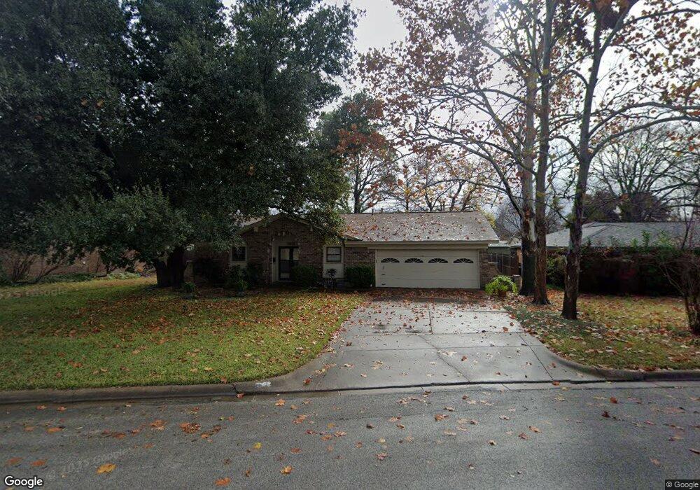
This home is located at 1025 Black St, Hurst, TX 76053 and is currently estimated at $290,867, approximately $197 per square foot. 1025 Black St is a home located in Tarrant County with nearby schools including Jack C Binion Elementary School, Richland Middle School, and Birdville High School.
Ownership History
Date
Name
Owned For
Owner Type
Purchase Details
Closed on
Jul 28, 1995
Sold by
Thompson Mark Monroe and Thompson Patricia Ann
Bought by
Spangler Marsha K
Current Estimated Value
Home Financials for this Owner
Home Financials are based on the most recent Mortgage that was taken out on this home.
Original Mortgage
$70,452
Interest Rate
7.49%
Mortgage Type
Seller Take Back
Purchase Details
Closed on
Dec 9, 1993
Sold by
Swain Edgar C and Swain Louise H
Bought by
Thompson Mark Monroe and Thompson Patricia Ann
Home Financials for this Owner
Home Financials are based on the most recent Mortgage that was taken out on this home.
Original Mortgage
$70,452
Interest Rate
7.19%
Mortgage Type
FHA
Create a Home Valuation Report for This Property
The Home Valuation Report is an in-depth analysis detailing your home's value as well as a comparison with similar homes in the area
Home Values in the Area
Average Home Value in this Area
Purchase History
| Date | Buyer | Sale Price | Title Company |
|---|---|---|---|
| Spangler Marsha K | -- | Rattikin Title Co | |
| Thompson Mark Monroe | -- | Lawyers American Title Co |
Source: Public Records
Mortgage History
| Date | Status | Borrower | Loan Amount |
|---|---|---|---|
| Closed | Spangler Marsha K | $70,452 | |
| Previous Owner | Thompson Mark Monroe | $70,452 |
Source: Public Records
Tax History Compared to Growth
Tax History
| Year | Tax Paid | Tax Assessment Tax Assessment Total Assessment is a certain percentage of the fair market value that is determined by local assessors to be the total taxable value of land and additions on the property. | Land | Improvement |
|---|---|---|---|---|
| 2025 | $1,442 | $203,264 | $60,398 | $142,866 |
| 2024 | $1,442 | $203,264 | $60,398 | $142,866 |
| 2023 | $4,208 | $184,981 | $50,318 | $134,663 |
| 2022 | $4,138 | $170,597 | $50,288 | $120,309 |
| 2021 | $3,947 | $152,153 | $45,000 | $107,153 |
| 2020 | $4,556 | $177,290 | $45,000 | $132,290 |
| 2019 | $4,248 | $178,493 | $45,000 | $133,493 |
| 2018 | $3,328 | $146,942 | $22,000 | $124,942 |
| 2017 | $3,565 | $154,025 | $22,000 | $132,025 |
| 2016 | $3,241 | $141,288 | $22,000 | $119,288 |
| 2015 | $2,612 | $110,400 | $17,000 | $93,400 |
| 2014 | $2,612 | $110,400 | $17,000 | $93,400 |
Source: Public Records
Map
Nearby Homes
- 1000 Madrid St
- 1016 Billie Ruth Ln
- 1108 Billie Ruth Ln
- 913 Zelda Dr
- 916 Zelda Dr
- 1001 Livingston Dr
- 1218 Wooded Trail
- 1220 Woodland Park Dr
- 1230 Woodland Park Dr
- 1230 Wooded Trail
- 853 Royal Terrace
- 833 W Cheryl Ave
- 829 Joanna Dr
- 820 Bedford Ct W
- 649 Timberline Dr
- 1204 Princess Ln
- 849 Wheelwood Dr
- 632 Melbourne Ct
- 512 Billie Ruth Ln
- 632 Forest Ln