
Seller's Agent in 2025
Taylor Ellis
Magnolia Realty Co.
(470) 949-4880
1 in this area
12 Total Sales
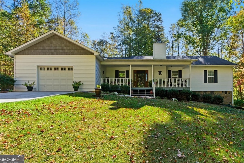
Tucked away off the road for total privacy, this charming 2-bedroom, 2-bath home offers the perfect mix of comfort and nature. Step inside to find real hardwood floors, a cozy stone fireplace that is wood burning, and a welcoming open layout that flows from the living room to the dining area and kitchen. The kitchen features solid wood cabinetry and plenty of space for home-cooked meals or coffee with a view. The full unfinished basement offers endless potential - whether you dream of extra living space, a workshop, or storage galore. Enjoy your morning coffee or unwind in the evenings on the porch overlooking a peaceful backyard surrounded by mature trees. Outside, you'll love the gorgeous 7.36-acre lot, complete with a gentle creek running through the property - perfect for exploring, relaxing, or simply enjoying the sounds of nature. This home is ideal for anyone looking for tranquility, space, and the beauty of country living - all while being just a short drive to town amenities.
Last Agent to Sell the Property
Magnolia Realty Co. License #446478 Listed on: 10/27/2025
| Date | Type | Sale Price | Title Company |
|---|---|---|---|
| Warranty Deed | $15,000 | -- | |
| Deed | -- | -- | |
| Deed | -- | -- | |
| Interfamily Deed Transfer | -- | -- | |
| Deed | -- | -- | |
| Deed | $87,000 | -- | |
| Deed | -- | -- |
| Date | Event | Price | List to Sale | Price per Sq Ft |
|---|---|---|---|---|
| 12/08/2025 12/08/25 | Sold | $340,000 | 0.0% | $251 / Sq Ft |
| 11/06/2025 11/06/25 | Pending | -- | -- | -- |
| 10/27/2025 10/27/25 | For Sale | $340,000 | -- | $251 / Sq Ft |
| Year | Tax Paid | Tax Assessment Tax Assessment Total Assessment is a certain percentage of the fair market value that is determined by local assessors to be the total taxable value of land and additions on the property. | Land | Improvement |
|---|---|---|---|---|
| 2025 | $255 | $125,028 | $12,758 | $112,270 |
| 2024 | $258 | $125,028 | $12,758 | $112,270 |
| 2023 | $258 | $113,065 | $10,207 | $102,858 |
| 2022 | $307 | $89,344 | $6,804 | $82,540 |
| 2021 | $309 | $76,042 | $5,444 | $70,598 |
| 2020 | $311 | $67,938 | $4,949 | $62,989 |
| 2019 | $319 | $63,083 | $4,949 | $58,134 |
| 2018 | $335 | $56,290 | $4,949 | $51,341 |
Seller's Agent in 2025
Taylor Ellis
Magnolia Realty Co.
(470) 949-4880
1 in this area
12 Total Sales
Buyer's Agent in 2025
Jessica Humphries
Atlanta Communities
(770) 870-4049
1 in this area
53 Total Sales
Source: Georgia MLS
MLS Number: 10632311
APN: 036-0024
Disclaimer: Certain information contained herein is derived from information provided by parties other than Homes.com. All information provided is deemed reliable, but is not guaranteed to be accurate and should be independently verified.
![]() The data relating to real estate for sale on this web site comes in part from the Broker Reciprocity Program of Georgia MLS. Real estate listings held by brokerage firms other than Redfin are marked with the Broker Reciprocity logo and detailed information about them includes the name of the listing brokers. Information deemed reliable but not guaranteed. Copyright 2026 Georgia MLS. All rights reserved.
The data relating to real estate for sale on this web site comes in part from the Broker Reciprocity Program of Georgia MLS. Real estate listings held by brokerage firms other than Redfin are marked with the Broker Reciprocity logo and detailed information about them includes the name of the listing brokers. Information deemed reliable but not guaranteed. Copyright 2026 Georgia MLS. All rights reserved.
Ask me questions while you tour the home.