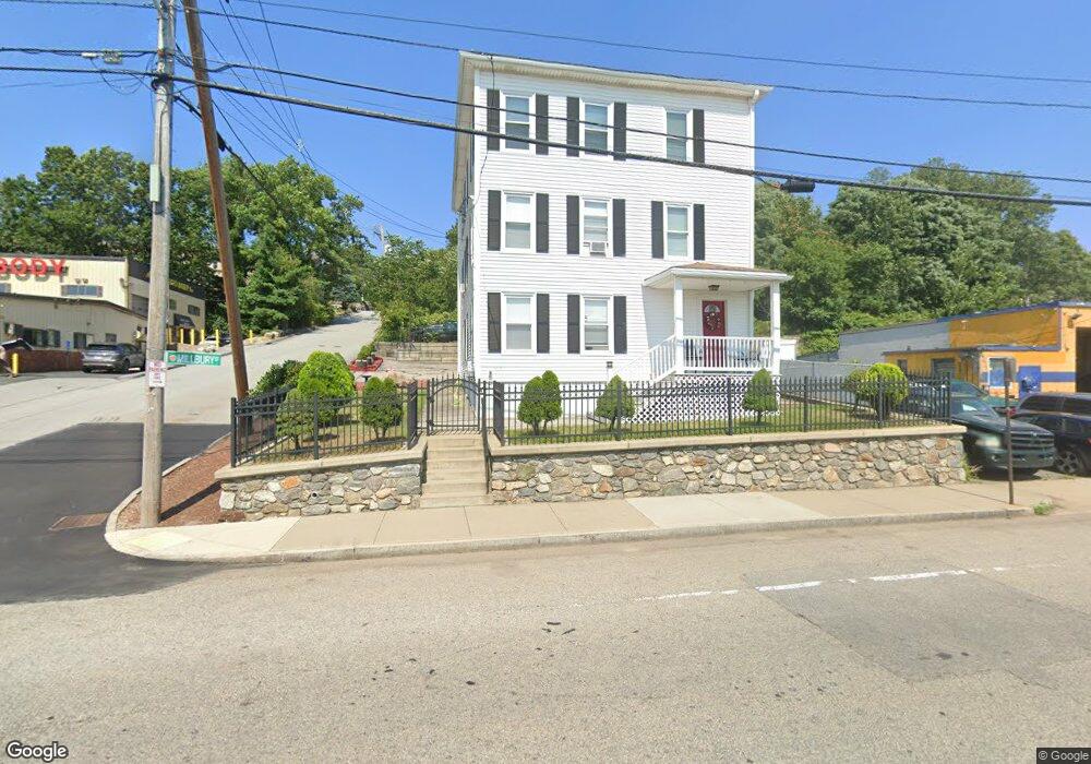
1025 Millbury St Worcester, MA 01607
Broadmeadow Brook NeighborhoodEstimated Value: $489,000 - $646,000
6
Beds
3
Baths
1,768
Sq Ft
$330/Sq Ft
Est. Value
About This Home
This home is located at 1025 Millbury St, Worcester, MA 01607 and is currently estimated at $583,333, approximately $329 per square foot. 1025 Millbury St is a home located in Worcester County with nearby schools including Vernon Hill Elementary School, Jacob Hiatt Magnet School, and Chandler Magnet.
Ownership History
Date
Name
Owned For
Owner Type
Purchase Details
Closed on
Jul 24, 2024
Sold by
Audette Normand R and Audette Frederick
Bought by
Ballard Rt and Audette
Current Estimated Value
Purchase Details
Closed on
May 10, 2022
Sold by
Audette Blanche L and Audette
Bought by
Audette Normand R and Audette Frederick
Purchase Details
Closed on
Nov 16, 1999
Sold by
Gareri Paula M and Rawinski Amelia A
Bought by
Rawinski Amelia A
Purchase Details
Closed on
Oct 11, 1991
Sold by
Rawinski Amelia
Bought by
Gareri Paula M
Home Financials for this Owner
Home Financials are based on the most recent Mortgage that was taken out on this home.
Original Mortgage
$68,000
Interest Rate
9.07%
Mortgage Type
Purchase Money Mortgage
Create a Home Valuation Report for This Property
The Home Valuation Report is an in-depth analysis detailing your home's value as well as a comparison with similar homes in the area
Home Values in the Area
Average Home Value in this Area
Purchase History
| Date | Buyer | Sale Price | Title Company |
|---|---|---|---|
| Ballard Rt | -- | None Available | |
| Ballard Rt | -- | None Available | |
| Audette Normand R | -- | None Available | |
| Audette Normand R | -- | None Available | |
| Audette Blanche L | -- | None Available | |
| Rawinski Amelia A | $50,000 | -- | |
| Gareri Paula M | $78,000 | -- |
Source: Public Records
Mortgage History
| Date | Status | Borrower | Loan Amount |
|---|---|---|---|
| Previous Owner | Gareri Paula M | $68,000 |
Source: Public Records
Tax History Compared to Growth
Tax History
| Year | Tax Paid | Tax Assessment Tax Assessment Total Assessment is a certain percentage of the fair market value that is determined by local assessors to be the total taxable value of land and additions on the property. | Land | Improvement |
|---|---|---|---|---|
| 2025 | $6,951 | $527,000 | $97,900 | $429,100 |
| 2024 | $6,464 | $470,100 | $97,900 | $372,200 |
| 2023 | $6,185 | $431,300 | $85,100 | $346,200 |
| 2022 | $5,403 | $355,200 | $68,100 | $287,100 |
| 2021 | $4,550 | $279,500 | $54,500 | $225,000 |
| 2020 | $4,264 | $250,800 | $54,500 | $196,300 |
| 2019 | $4,266 | $237,000 | $49,000 | $188,000 |
| 2018 | $3,237 | $171,200 | $49,000 | $122,200 |
| 2017 | $3,087 | $160,600 | $49,000 | $111,600 |
| 2016 | $2,900 | $140,700 | $36,400 | $104,300 |
| 2015 | $2,824 | $140,700 | $36,400 | $104,300 |
| 2014 | $2,749 | $140,700 | $36,400 | $104,300 |
Source: Public Records
Map
Nearby Homes
- 36 Gibbs St Unit 15
- 11 Gibbs St Unit 40
- 11 Gibbs St Unit 12
- 92 Greenwood St
- 5 Tatman St
- 32 Kosta St
- 17 Thenius St
- 216 Providence St
- 4 Crest Ave
- 45 Dillon St
- 32 Ames St
- 26 Maxwell St
- 64 Stockton St
- 29 Steele St
- 42 Bridgeport St
- 23 Woodford St
- 184 Vernon St
- 10 Rutledge St Unit 3G
- 18 Fairbanks St
- 10 Gensell Ave