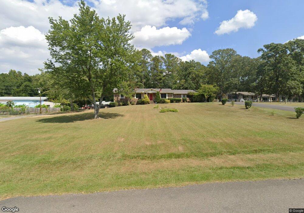
1025 S Watson Dr Centre, AL 35960
Estimated Value: $155,000 - $275,000
Studio
1
Bath
1,566
Sq Ft
$145/Sq Ft
Est. Value
About This Home
This home is located at 1025 S Watson Dr, Centre, AL 35960 and is currently estimated at $227,521, approximately $145 per square foot. 1025 S Watson Dr is a home located in Cherokee County with nearby schools including Cherokee County High School.
Ownership History
Date
Name
Owned For
Owner Type
Purchase Details
Closed on
Nov 19, 2019
Sold by
Tillery Frances
Bought by
Lee Rhonda Jean
Current Estimated Value
Purchase Details
Closed on
Apr 8, 2016
Sold by
Steed Chad
Bought by
Tillery Frances
Home Financials for this Owner
Home Financials are based on the most recent Mortgage that was taken out on this home.
Original Mortgage
$108,200
Interest Rate
3.71%
Mortgage Type
Stand Alone First
Purchase Details
Closed on
May 24, 2010
Sold by
Barnes Travis Edward and Barnes Amy H
Bought by
Steed Chad
Home Financials for this Owner
Home Financials are based on the most recent Mortgage that was taken out on this home.
Original Mortgage
$117,856
Interest Rate
5.03%
Purchase Details
Closed on
Nov 22, 2005
Bought by
Barnes Travis Edward and Barnes Amy H
Create a Home Valuation Report for This Property
The Home Valuation Report is an in-depth analysis detailing your home's value as well as a comparison with similar homes in the area
Home Values in the Area
Average Home Value in this Area
Purchase History
| Date | Buyer | Sale Price | Title Company |
|---|---|---|---|
| Lee Rhonda Jean | -- | None Available | |
| Tillery Frances | $115,000 | None Available | |
| Steed Chad | -- | -- | |
| Barnes Travis Edward | -- | -- |
Source: Public Records
Mortgage History
| Date | Status | Borrower | Loan Amount |
|---|---|---|---|
| Previous Owner | Tillery Frances | $108,200 | |
| Previous Owner | Steed Chad | $117,856 |
Source: Public Records
Tax History
| Year | Tax Paid | Tax Assessment Tax Assessment Total Assessment is a certain percentage of the fair market value that is determined by local assessors to be the total taxable value of land and additions on the property. | Land | Improvement |
|---|---|---|---|---|
| 2025 | -- | $18,000 | $460 | $17,540 |
| 2024 | -- | $18,000 | $460 | $17,540 |
| 2023 | $0 | $21,120 | $0 | $0 |
| 2022 | $884 | $2,400 | $460 | $1,940 |
| 2021 | $414 | $14,600 | $460 | $14,140 |
| 2020 | $0 | $14,600 | $460 | $14,140 |
| 2019 | $0 | $13,980 | $460 | $13,520 |
| 2018 | $544 | $14,100 | $0 | $0 |
| 2017 | $455 | $117,400 | $0 | $0 |
| 2016 | $1,104 | $117,400 | $0 | $0 |
| 2015 | $1,104 | $117,400 | $0 | $0 |
| 2014 | $1,072 | $114,020 | $0 | $0 |
| 2013 | $1,072 | $114,020 | $0 | $0 |
Source: Public Records
Map
Nearby Homes
- 1016 Woodland St
- 2150 W Main St
- Lot 1 Pratt St
- 307 King St
- 303 Auburn St
- Lot 5 Tol St
- Lot 11 Tol St
- Lot 6 Tol St
- Lot 10 Tol St
- 20 ACRES Hood St
- 9405 Highway 411
- 202 Iris Dr
- 216 Iris Dr
- NA Chesnut Bypass
- 690 Garrett Dr
- 300 Hill Rd
- 0 Old Highway 411 Unit 10465381
- 307 Ray St
- 0 Ray St
- 9.06 ac Old Highway 411
- 1075 S Watson Dr
- 975 S Watson Dr
- LT 2nd Ave
- 1050 S Watson Dr
- 1010 S Watson Dr
- 976 S Watson Dr
- 955 S Watson Dr
- 975 2nd Ave W
- 966 S Watson Dr
- 965 S Watson Dr
- 1001 2nd Ave W
- 901 S Watson Dr
- 1006 2nd Ave W
- 976 David St
- 955 2nd Ave W
- 1149 S Watson Dr
- 1000 David St
- 1027 1st Ave W
- 1005 1st Ave W
- 1008 2nd Ave W
Your Personal Tour Guide
Ask me questions while you tour the home.