Estimated Value: $212,000 - $367,000
2
Beds
2
Baths
1,446
Sq Ft
$217/Sq Ft
Est. Value
About This Home
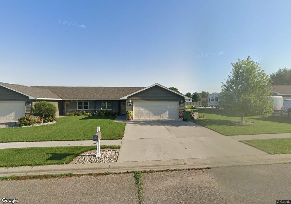
This home is located at 1025 Saxton Dr, Huron, SD 57350 and is currently estimated at $313,735, approximately $216 per square foot. 1025 Saxton Dr is a home located in Beadle County with nearby schools including Huron High School, Holy Trinity Catholic Elementary School, and James Valley Christian School.
Ownership History
Date
Name
Owned For
Owner Type
Purchase Details
Closed on
Mar 31, 2025
Bought by
Shrewsbury Susan
Current Estimated Value
Purchase Details
Closed on
Dec 2, 2013
Sold by
K & S Development Llc
Bought by
Schoenhard
Home Financials for this Owner
Home Financials are based on the most recent Mortgage that was taken out on this home.
Original Mortgage
$164,400
Interest Rate
4.1%
Mortgage Type
New Conventional
Create a Home Valuation Report for This Property
The Home Valuation Report is an in-depth analysis detailing your home's value as well as a comparison with similar homes in the area
Home Values in the Area
Average Home Value in this Area
Purchase History
| Date | Buyer | Sale Price | Title Company |
|---|---|---|---|
| Shrewsbury Susan | $325,000 | -- | |
| Schoenhard | -- | -- | |
| Schoenhard | -- | -- |
Source: Public Records
Mortgage History
| Date | Status | Borrower | Loan Amount |
|---|---|---|---|
| Previous Owner | Schoenhard | $164,400 |
Source: Public Records
Tax History
| Year | Tax Paid | Tax Assessment Tax Assessment Total Assessment is a certain percentage of the fair market value that is determined by local assessors to be the total taxable value of land and additions on the property. | Land | Improvement |
|---|---|---|---|---|
| 2025 | $4,958 | $326,741 | $8,021 | $318,720 |
| 2024 | $4,674 | $301,673 | $8,021 | $293,652 |
| 2023 | $4,130 | $234,645 | $8,021 | $226,624 |
| 2022 | $3,996 | $224,755 | $8,021 | $216,734 |
| 2021 | $3,711 | $214,865 | $8,021 | $206,844 |
| 2020 | $4,450 | $201,327 | $8,021 | $193,306 |
| 2019 | $4,502 | $201,327 | $8,021 | $193,306 |
| 2018 | -- | $201,327 | $8,021 | $193,306 |
| 2017 | -- | $163,683 | $8,021 | $155,662 |
| 2016 | -- | $120,420 | $8,021 | $112,399 |
| 2015 | -- | $84,568 | $8,021 | $76,547 |
| 2014 | -- | $43,872 | $8,021 | $35,851 |
| 2013 | -- | $8,021 | $8,021 | $0 |
Source: Public Records
Map
Nearby Homes
- 679 10th St SW
- 545 Montana Ave SW
- 540 18th St SW
- 1980 Meadowlark Ln Unit 302
- 1023 Dakota Ave S
- 963 Dakota Ave S
- 0 S Dakota 37
- 0 21st St Unit 25-140
- 1980 Illinois Ave SW
- 0 Lot 7 Blk 1 McDonald Dr
- 0 Lot 6 Blk 1 McDonald Dr
- 0 Lot 10 Blk 1 McDonald Dr
- 132 7th St SE
- 551 Kansas Ave SE
- 0 Lot 6 Blk 2 McDonald Dr
- 0 Lot 7 Blk 2 McDonald Dr
- 1810 Kansas Ave
- 1250 Idaho Ave SE
- 1949 Lampert Dr
- 69 21st St SE
- 1035 Saxton Dr
- 985 Saxton Dr
- 0 Saxton Dr
- 1075 Saxton Dr
- 955 Saxton Dr
- 980 Saxton Dr
- 1020 Saxton Dr
- 1050 Saxton Dr
- 1085 Saxton Dr
- 950 Saxton Dr
- 1165 Arizona Ave SW
- 1155 Arizona Ave SW
- 1225 Arizona Ave SW
- 1139 Arizona Ave SW
- 1118 Michigan Ave SW
- 1122 Minnesota Ave SW
- 895 12th St SW
- 1099 Michigan Ave SW
- 890 12th St SW
- 1115 Arizona Ave SW
Your Personal Tour Guide
Ask me questions while you tour the home.