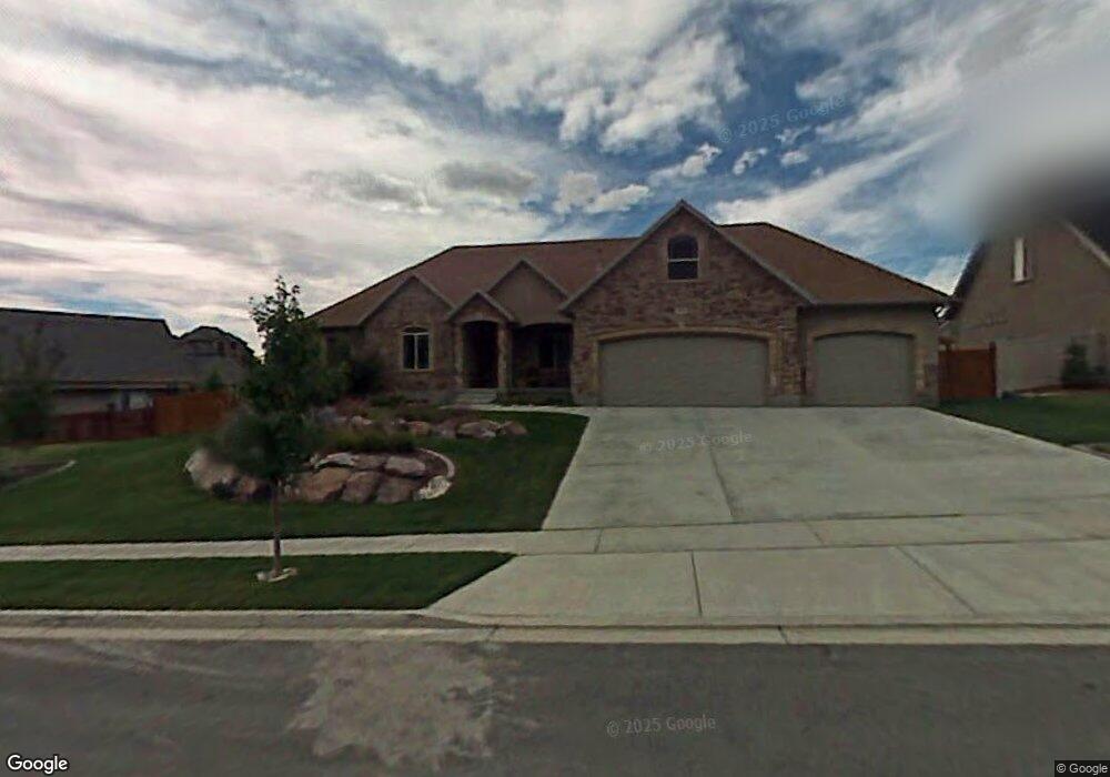
10251 N Bristlecone Way Cedar Hills, UT 84062
Estimated Value: $833,000 - $899,093
6
Beds
4
Baths
4,193
Sq Ft
$205/Sq Ft
Est. Value
About This Home
This home is located at 10251 N Bristlecone Way, Cedar Hills, UT 84062 and is currently estimated at $859,523, approximately $204 per square foot. 10251 N Bristlecone Way is a home located in Utah County with nearby schools including Cedar Ridge Elementary School, Mountain Ridge Junior High School, and Lone Peak High School.
Ownership History
Date
Name
Owned For
Owner Type
Purchase Details
Closed on
Mar 29, 2024
Sold by
Spackman Kenneth R and Spackman Deborah H
Bought by
Kenneth And Deborah Spackman Living Trust and Spackman
Current Estimated Value
Home Financials for this Owner
Home Financials are based on the most recent Mortgage that was taken out on this home.
Original Mortgage
$250,000
Outstanding Balance
$246,279
Interest Rate
6.9%
Mortgage Type
Credit Line Revolving
Estimated Equity
$613,244
Purchase Details
Closed on
Feb 29, 2024
Sold by
Spackman Kenneth
Bought by
Kenneth And Deborah Spackman Living Trust and Spackman
Home Financials for this Owner
Home Financials are based on the most recent Mortgage that was taken out on this home.
Original Mortgage
$250,000
Outstanding Balance
$246,279
Interest Rate
6.9%
Mortgage Type
Credit Line Revolving
Estimated Equity
$613,244
Purchase Details
Closed on
Jun 27, 2016
Sold by
Spackman Kenneth
Bought by
Spackman Kenneth and Spackman Deborah
Home Financials for this Owner
Home Financials are based on the most recent Mortgage that was taken out on this home.
Original Mortgage
$366,400
Interest Rate
3.64%
Mortgage Type
New Conventional
Purchase Details
Closed on
Oct 25, 2010
Sold by
Kammer David
Bought by
Kammer Davy and Kammer Holly
Home Financials for this Owner
Home Financials are based on the most recent Mortgage that was taken out on this home.
Original Mortgage
$290,500
Interest Rate
4.33%
Mortgage Type
New Conventional
Purchase Details
Closed on
Dec 16, 2008
Sold by
Kammer David
Bought by
Kammer Davy and Kammer Holly
Home Financials for this Owner
Home Financials are based on the most recent Mortgage that was taken out on this home.
Original Mortgage
$288,600
Interest Rate
6.16%
Mortgage Type
Purchase Money Mortgage
Purchase Details
Closed on
Sep 5, 2008
Sold by
Kammer David
Bought by
Kammer Davy and Kammer Holly
Home Financials for this Owner
Home Financials are based on the most recent Mortgage that was taken out on this home.
Original Mortgage
$283,700
Interest Rate
6.5%
Mortgage Type
Purchase Money Mortgage
Create a Home Valuation Report for This Property
The Home Valuation Report is an in-depth analysis detailing your home's value as well as a comparison with similar homes in the area
Home Values in the Area
Average Home Value in this Area
Purchase History
| Date | Buyer | Sale Price | Title Company |
|---|---|---|---|
| Kenneth And Deborah Spackman Living Trust | -- | Meridian Title Company | |
| Spackman Kenneth R | -- | Meridian Title Company | |
| Kenneth And Deborah Spackman Living Trust | -- | None Listed On Document | |
| Spackman Kenneth | -- | Utah First Title Ins Ag | |
| Spackman Kenneth | -- | North American Title | |
| Kammer Davy | -- | Utah First Title Insurance | |
| Kammer David | -- | Utah First Title Insurance | |
| Kammer Davy | -- | Utah First Title Insurance | |
| Kammer David | -- | Utah First Title Insurance | |
| Kammer Davy | -- | Utah First Title Insurance | |
| Kammer David | -- | Utah First Title Insurance |
Source: Public Records
Mortgage History
| Date | Status | Borrower | Loan Amount |
|---|---|---|---|
| Open | Spackman Kenneth R | $250,000 | |
| Previous Owner | Spackman Kenneth | $366,400 | |
| Previous Owner | Kammer David | $290,500 | |
| Previous Owner | Kammer David | $288,600 | |
| Previous Owner | Kammer David | $283,700 |
Source: Public Records
Tax History Compared to Growth
Tax History
| Year | Tax Paid | Tax Assessment Tax Assessment Total Assessment is a certain percentage of the fair market value that is determined by local assessors to be the total taxable value of land and additions on the property. | Land | Improvement |
|---|---|---|---|---|
| 2025 | $3,451 | $453,255 | $317,800 | $506,300 |
| 2024 | $3,451 | $408,705 | $0 | $0 |
| 2023 | $3,179 | $404,470 | $0 | $0 |
| 2022 | $3,396 | $422,015 | $0 | $0 |
| 2021 | $3,057 | $566,000 | $206,700 | $359,300 |
| 2020 | $2,835 | $512,200 | $191,400 | $320,800 |
| 2019 | $2,651 | $497,300 | $179,900 | $317,400 |
| 2018 | $2,786 | $492,500 | $179,900 | $312,600 |
| 2017 | $2,576 | $243,485 | $0 | $0 |
| 2016 | $2,453 | $215,655 | $0 | $0 |
| 2015 | $2,592 | $215,655 | $0 | $0 |
| 2014 | $2,316 | $191,345 | $0 | $0 |
Source: Public Records
Map
Nearby Homes
- 4198 W Sage Rd N
- 10412 N Bayhill Dr
- 10358 N Tamarack Way
- 3870 Mountaintop Cir
- 4292 W Joshua Ln
- 10514 N Doral Dr
- 10456 N Morgan Blvd
- 3851 W Mountaintop Cir Unit 5
- 10587 N Avalon St
- 10207 N Cottonwood Dr
- 10448 Sage Vista Ln
- 10468 N Sage Vista Ln
- 9900 N Meadow Dr
- 4083 W Hayes Cir
- 4084 W Shinnecock
- 10795 N La Costa
- 4124 N 810 W
- 4616 W Carriage Ln
- 9752 N Dorchester Dr
- 10052 N Marigold Ln
- 10251 N Bristlecone Way Unit 63
- 10251 Bristlecone Way
- 10265 Bristlecone Way
- 10265 N Bristlecone Way Unit 62
- 10265 N Bristlecone Way
- 10246 N Ironwood Dr
- 10246 N Ironwood Dr
- 10237 Bristlecone Way
- 10262 Ironwood Dr
- 10262 N Ironwood Dr Unit 52
- 10262 N Ironwood Dr
- 10258 Bristlecone Way
- 10258 Bristlecone Way Unit 38
- 10238 Bristlecone Way
- 10238 Bristlecone Way Unit 39
- 10283 Bristlecone Way
- 10283 Bristlecone Way Unit 61
- 10272 Bristlecone Way
- 10272 Bristlecone Way Unit 37B
- 10282 Ironwood Dr