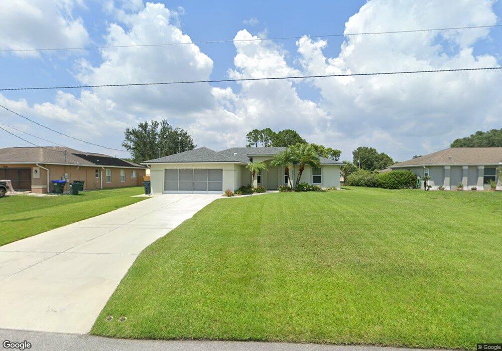
1026 Calgary Rd North Port, FL 34288
Estimated Value: $277,947 - $339,000
3
Beds
2
Baths
1,467
Sq Ft
$214/Sq Ft
Est. Value
About This Home
This home is located at 1026 Calgary Rd, North Port, FL 34288 and is currently estimated at $313,987, approximately $214 per square foot. 1026 Calgary Rd is a home located in Sarasota County with nearby schools including Toledo Blade Elementary School, North Port High School, and Woodland Middle School.
Ownership History
Date
Name
Owned For
Owner Type
Purchase Details
Closed on
Dec 7, 2009
Sold by
Moitoso Frank D and Moitoso Mary P
Bought by
Moitoso Frank D and Moitoso Mary P
Current Estimated Value
Purchase Details
Closed on
Feb 14, 2005
Sold by
Tyler Earl J
Bought by
Moitoso Frank and Moitoso Mary P
Purchase Details
Closed on
Feb 11, 2004
Sold by
Gulfstream Dev Group L L C
Bought by
Tyler Earl J
Home Financials for this Owner
Home Financials are based on the most recent Mortgage that was taken out on this home.
Original Mortgage
$135,500
Interest Rate
5.85%
Create a Home Valuation Report for This Property
The Home Valuation Report is an in-depth analysis detailing your home's value as well as a comparison with similar homes in the area
Home Values in the Area
Average Home Value in this Area
Purchase History
| Date | Buyer | Sale Price | Title Company |
|---|---|---|---|
| Moitoso Frank D | -- | Attorney | |
| Moitoso Frank | $218,000 | Paradise Title Services Inc | |
| Tyler Earl J | $142,700 | -- |
Source: Public Records
Mortgage History
| Date | Status | Borrower | Loan Amount |
|---|---|---|---|
| Previous Owner | Tyler Earl J | $135,500 |
Source: Public Records
Tax History Compared to Growth
Tax History
| Year | Tax Paid | Tax Assessment Tax Assessment Total Assessment is a certain percentage of the fair market value that is determined by local assessors to be the total taxable value of land and additions on the property. | Land | Improvement |
|---|---|---|---|---|
| 2024 | $1,710 | $108,022 | -- | -- |
| 2023 | $1,710 | $104,876 | $0 | $0 |
| 2022 | $1,372 | $81,433 | $0 | $0 |
| 2021 | $1,342 | $79,061 | $0 | $0 |
| 2020 | $1,310 | $77,969 | $0 | $0 |
| 2019 | $1,266 | $76,216 | $0 | $0 |
| 2018 | $1,154 | $74,795 | $0 | $0 |
| 2017 | $1,125 | $73,257 | $0 | $0 |
| 2016 | $1,137 | $114,600 | $4,800 | $109,800 |
| 2015 | $1,155 | $99,000 | $3,900 | $95,100 |
| 2014 | $1,133 | $69,641 | $0 | $0 |
Source: Public Records
Map
Nearby Homes
- 1035 Cragmont Ave
- LOT 10 & 11 Amnesty Dr
- 1221 Calgary Rd
- 0 Cathedall Ave Unit A4534111
- 0 Amnesty Dr Unit A11796643
- 0 Amnesty Dr Unit MFRC7505022
- 0 Calgary Rd
- 1674 Ardisia St
- 1296 Banter Cir
- 1294 Napoleon Rd
- Palm Beach Plan at North Port - Port Charlotte
- Siesta Key Plan at North Port - Port Charlotte
- Lido Key Plan at North Port - Port Charlotte
- Cedar Key Plan at North Port - Port Charlotte
- Estero II Plan at North Port - Port Charlotte
- Brickell Plan at North Port - Port Charlotte
- Caladesi Plan at North Port - Port Charlotte
- Vero Plan at North Port - Port Charlotte
- Marco Plan at North Port - Port Charlotte
- Tortuga Plan at North Port
- 1044 Calgary Rd
- 1008 Calgary Rd
- 0000 Calgary Rd
- 1027 Calgary Rd
- 1062 Calgary Rd
- 1105 Cathedall Ave
- 1009 Calgary Rd
- 2113 Amnesty Dr
- 1081 Calgary Rd
- 1080 Calgary Rd
- 2130 Amnesty Dr
- 1098 Calgary Rd
- 1123 Cathedall Ave
- 2118 Amnesty Dr
- 2166 Amnesty Dr
- 1064 Crimson Ave
- 1014 Cathedall Ave
- 1066 Cathedall Ave
- 2094 Amnesty Dr
- Crimson Ave