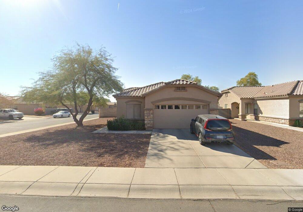
1026 S 4th Ave Avondale, AZ 85323
Old Town NeighborhoodEstimated Value: $312,604 - $366,000
3
Beds
2
Baths
1,672
Sq Ft
$206/Sq Ft
Est. Value
About This Home
This home is located at 1026 S 4th Ave, Avondale, AZ 85323 and is currently estimated at $344,401, approximately $205 per square foot. 1026 S 4th Ave is a home located in Maricopa County with nearby schools including Michael Anderson School, Desert Edge High School, and Estrella High School.
Ownership History
Date
Name
Owned For
Owner Type
Purchase Details
Closed on
Oct 24, 2016
Sold by
White White M and White Lucille
Bought by
White White M and White Lucille L
Current Estimated Value
Purchase Details
Closed on
Sep 19, 2005
Sold by
Chapman Peter and Chapman Gay
Bought by
White M Dean and White Lucille
Home Financials for this Owner
Home Financials are based on the most recent Mortgage that was taken out on this home.
Original Mortgage
$128,000
Outstanding Balance
$70,192
Interest Rate
6.25%
Mortgage Type
Purchase Money Mortgage
Estimated Equity
$274,209
Purchase Details
Closed on
Jul 23, 2003
Sold by
The Creative Classics Co
Bought by
Chapman Peter and Chapman Gay
Home Financials for this Owner
Home Financials are based on the most recent Mortgage that was taken out on this home.
Original Mortgage
$101,700
Interest Rate
5.13%
Mortgage Type
New Conventional
Create a Home Valuation Report for This Property
The Home Valuation Report is an in-depth analysis detailing your home's value as well as a comparison with similar homes in the area
Home Values in the Area
Average Home Value in this Area
Purchase History
| Date | Buyer | Sale Price | Title Company |
|---|---|---|---|
| White White M | -- | None Available | |
| White M Dean | $160,000 | Chicago Title Insurance Co | |
| Chapman Peter | $127,145 | Security Title Agency |
Source: Public Records
Mortgage History
| Date | Status | Borrower | Loan Amount |
|---|---|---|---|
| Open | White M Dean | $128,000 | |
| Previous Owner | Chapman Peter | $101,700 | |
| Closed | White M Dean | $32,000 |
Source: Public Records
Tax History Compared to Growth
Tax History
| Year | Tax Paid | Tax Assessment Tax Assessment Total Assessment is a certain percentage of the fair market value that is determined by local assessors to be the total taxable value of land and additions on the property. | Land | Improvement |
|---|---|---|---|---|
| 2025 | $1,111 | $9,821 | -- | -- |
| 2024 | $1,023 | $9,353 | -- | -- |
| 2023 | $1,023 | $26,930 | $5,380 | $21,550 |
| 2022 | $986 | $19,780 | $3,950 | $15,830 |
| 2021 | $1,039 | $18,170 | $3,630 | $14,540 |
| 2020 | $1,007 | $16,960 | $3,390 | $13,570 |
| 2019 | $1,001 | $13,970 | $2,790 | $11,180 |
| 2018 | $1,005 | $12,460 | $2,490 | $9,970 |
| 2017 | $980 | $11,600 | $2,320 | $9,280 |
| 2016 | $994 | $11,280 | $2,250 | $9,030 |
| 2015 | $929 | $9,850 | $1,970 | $7,880 |
Source: Public Records
Map
Nearby Homes
- 830 S Greenleaf Ln
- 300 W Lower Buckeye Rd Unit 26
- 127 W Main St Unit 6
- 0 Lower Buckeye -- Unit 12
- 110 W Main St
- 607 S 1st St
- 31 W Aragon Ln
- 629 S 4th St
- 622 E Elm Ln
- 400 E Main St Unit 23
- 448 E Main St Unit 18
- 535 E Agua Fria Ln
- 1010 S 5th St
- 823 E Agua Fria Ln
- 831 E Agua Fria Ln
- 814 E Agua Fria Ln
- 845 E Agua Fria Ln
- 919 E Agua Fria Ln
- 917 E Agua Fria Ln
- 206 N 5th St