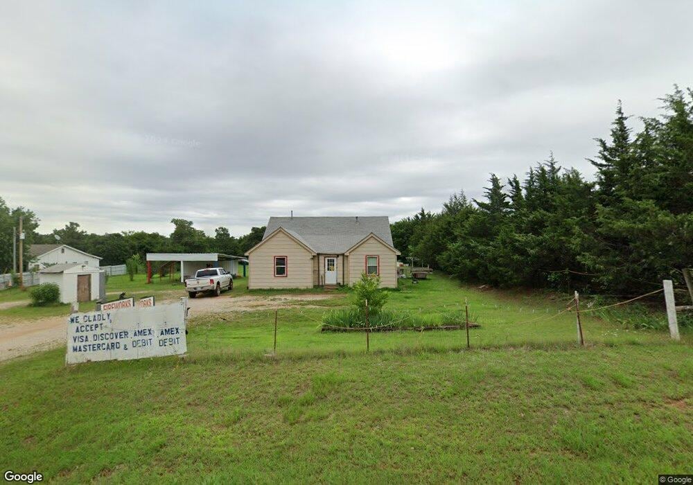
102602 S Highway 102 McLoud, OK 74851
Estimated Value: $121,815 - $282,000
3
Beds
1
Bath
1,278
Sq Ft
$177/Sq Ft
Est. Value
About This Home
This home is located at 102602 S Highway 102, McLoud, OK 74851 and is currently estimated at $225,938, approximately $176 per square foot. 102602 S Highway 102 is a home with nearby schools including Anna May Daulton Elementary School, Louise Cabaniss Elementary School, and Cora Spencer Elementary School.
Ownership History
Date
Name
Owned For
Owner Type
Purchase Details
Closed on
Nov 12, 1996
Sold by
Wagner Richard D and Wagner Lisa G
Bought by
Moore Jeffrey T and Moore Jeanette
Current Estimated Value
Purchase Details
Closed on
Mar 5, 1993
Sold by
Sec Housing & Urban Devel
Bought by
Wagner Richard D and Wagner Lisa
Purchase Details
Closed on
Jan 6, 1993
Sold by
Boklahoma Mortgage Cor
Bought by
Secretary Housing & Urban
Purchase Details
Closed on
Dec 22, 1992
Sold by
Brixey A T
Bought by
Boklahoma Mortgage Cor
Create a Home Valuation Report for This Property
The Home Valuation Report is an in-depth analysis detailing your home's value as well as a comparison with similar homes in the area
Home Values in the Area
Average Home Value in this Area
Purchase History
| Date | Buyer | Sale Price | Title Company |
|---|---|---|---|
| Moore Jeffrey T | $42,500 | -- | |
| Wagner Richard D | $6,000 | -- | |
| Secretary Housing & Urban | -- | -- | |
| Boklahoma Mortgage Cor | -- | -- |
Source: Public Records
Tax History Compared to Growth
Tax History
| Year | Tax Paid | Tax Assessment Tax Assessment Total Assessment is a certain percentage of the fair market value that is determined by local assessors to be the total taxable value of land and additions on the property. | Land | Improvement |
|---|---|---|---|---|
| 2025 | $489 | $5,161 | $2,238 | $2,923 |
| 2024 | $489 | $4,011 | $3,405 | $606 |
| 2023 | $489 | $7,855 | $3,405 | $4,450 |
| 2022 | $413 | $4,866 | $2,078 | $2,788 |
| 2021 | $398 | $4,724 | $2,029 | $2,695 |
| 2020 | $392 | $4,587 | $1,500 | $3,087 |
| 2019 | $377 | $4,453 | $1,534 | $2,919 |
| 2018 | $369 | $4,323 | $1,431 | $2,892 |
| 2017 | $333 | $4,038 | $1,495 | $2,543 |
| 2016 | $324 | $3,920 | $1,196 | $2,724 |
| 2015 | $269 | $3,805 | $1,158 | $2,647 |
| 2014 | $227 | $3,695 | $1,788 | $1,907 |
Source: Public Records
Map
Nearby Homes
- 331899 Timber Ln
- 332939 E 1020 Rd
- 331908 Shadow Wood Dr
- 102025 S 3330 Rd
- 101396 S Bedrock Cir
- 100861 S Red Rock Trail
- 0005 NE 50th St
- 100711 S Stonecrest Cir
- 100859 S Red Rock Trail
- 334169 E 1010 Rd
- 102590 S 3298 Rd
- 0 S 3307 Rd
- 334174 E Painted Sky Rd
- 0004 S 3340 10 Acres Rd
- 334273 E Painted Sky Dr
- 100782 S 3305 Rd
- 4640 Lincoln Landing
- 4616 Lincoln Landing
- 4624 Lincoln Landing
- 3872 Ada Ave
- 102580 S Highway 102
- 102670 S Highway 102
- 326 N Highway 102
- 327 N Highway 102
- 322 N Highway 102
- 320 N Highway 102
- 336 N Highway 102
- 317 N Highway 102
- 334 N Highway 102
- 338 N Highway 102
- 102902 S Highway 102
- 316 N Highway 102
- 1030 E E Rd
- 102292 S Highway 102
- 102211 S Highway 102
- 336076 E 1030 Rd
- 6 NE 50th St
- 0 E 1030 Rd
- 328 N Highway 102
- 102821 S 3325 Rd