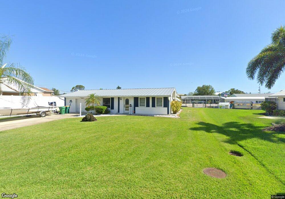
1027 Grant St Englewood, FL 34224
Englewood South NeighborhoodEstimated Value: $280,864 - $432,000
2
Beds
2
Baths
1,086
Sq Ft
$337/Sq Ft
Est. Value
About This Home
This home is located at 1027 Grant St, Englewood, FL 34224 and is currently estimated at $366,466, approximately $337 per square foot. 1027 Grant St is a home located in Charlotte County with nearby schools including Vineland Elementary School, L.A. Ainger Middle School, and Lemon Bay High School.
Ownership History
Date
Name
Owned For
Owner Type
Purchase Details
Closed on
Aug 19, 2003
Sold by
Boyd James E and Boyd Marilyn C
Bought by
Haworth G Preston and Haworth Margaret
Current Estimated Value
Purchase Details
Closed on
Oct 13, 1995
Sold by
Moore L William
Bought by
Boyd James E and Boyd Marilyn C
Home Financials for this Owner
Home Financials are based on the most recent Mortgage that was taken out on this home.
Original Mortgage
$92,000
Interest Rate
7.57%
Create a Home Valuation Report for This Property
The Home Valuation Report is an in-depth analysis detailing your home's value as well as a comparison with similar homes in the area
Home Values in the Area
Average Home Value in this Area
Purchase History
| Date | Buyer | Sale Price | Title Company |
|---|---|---|---|
| Haworth G Preston | $208,000 | -- | |
| Boyd James E | $115,000 | -- |
Source: Public Records
Mortgage History
| Date | Status | Borrower | Loan Amount |
|---|---|---|---|
| Previous Owner | Boyd James E | $92,000 |
Source: Public Records
Tax History Compared to Growth
Tax History
| Year | Tax Paid | Tax Assessment Tax Assessment Total Assessment is a certain percentage of the fair market value that is determined by local assessors to be the total taxable value of land and additions on the property. | Land | Improvement |
|---|---|---|---|---|
| 2023 | $5,191 | $249,092 | $0 | $0 |
| 2022 | $4,920 | $295,152 | $119,530 | $175,622 |
| 2021 | $4,324 | $217,985 | $112,499 | $105,486 |
| 2020 | $4,017 | $199,542 | $112,499 | $87,043 |
| 2019 | $3,886 | $196,488 | $112,499 | $83,989 |
| 2018 | $3,434 | $185,036 | $112,499 | $72,537 |
| 2017 | $3,141 | $158,004 | $112,499 | $45,505 |
| 2016 | $2,876 | $147,051 | $0 | $0 |
| 2015 | $2,841 | $140,698 | $0 | $0 |
| 2014 | $2,663 | $127,907 | $0 | $0 |
Source: Public Records
Map
Nearby Homes
- 1018 Lee St
- 1966 Trout Cir
- 1649 Manor Rd
- 1019 Schooner Ln
- 1774 Edison Dr
- 1041 Schooner Ln
- 1753 Walden Ct
- 1605 Manor Rd
- 1084 Humboldt St
- 1713 Walden Ct
- 7 Manor Ct
- 2035 S Mccall Rd
- 1999 Placida Rd
- 1531 Placida Rd Unit 8-101
- 1531 Placida Rd Unit 204
- 1531 Placida Rd Unit 10-201
- 1531 Placida Rd Unit 4UNIT103
- 1531 Placida Rd Unit 8UNIT203
- 1761 Winstan Ave
- 1751 Winstan Ave