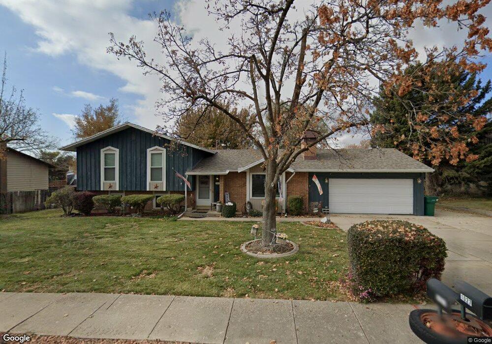
1027 Kimberly Dr Layton, UT 84040
Estimated Value: $500,000 - $628,000
4
Beds
3
Baths
2,101
Sq Ft
$266/Sq Ft
Est. Value
About This Home
This home is located at 1027 Kimberly Dr, Layton, UT 84040 and is currently estimated at $557,833, approximately $265 per square foot. 1027 Kimberly Dr is a home located in Davis County with nearby schools including King Elementary School, Central Davis Junior High School, and Layton High School.
Ownership History
Date
Name
Owned For
Owner Type
Purchase Details
Closed on
Sep 27, 2001
Sold by
Masopust Paul J
Bought by
Masopust Paul J and Masopust Brenda A
Current Estimated Value
Purchase Details
Closed on
Jul 26, 2001
Sold by
Stach William R and Stach Sandra B
Bought by
Masopust Paul J
Home Financials for this Owner
Home Financials are based on the most recent Mortgage that was taken out on this home.
Original Mortgage
$140,000
Interest Rate
6.91%
Create a Home Valuation Report for This Property
The Home Valuation Report is an in-depth analysis detailing your home's value as well as a comparison with similar homes in the area
Home Values in the Area
Average Home Value in this Area
Purchase History
| Date | Buyer | Sale Price | Title Company |
|---|---|---|---|
| Masopust Paul J | -- | Bonneville Title Company Inc | |
| Masopust Paul J | -- | Bonneville Title Company |
Source: Public Records
Mortgage History
| Date | Status | Borrower | Loan Amount |
|---|---|---|---|
| Previous Owner | Masopust Paul J | $140,000 |
Source: Public Records
Tax History
| Year | Tax Paid | Tax Assessment Tax Assessment Total Assessment is a certain percentage of the fair market value that is determined by local assessors to be the total taxable value of land and additions on the property. | Land | Improvement |
|---|---|---|---|---|
| 2025 | $2,568 | $269,500 | $179,390 | $90,110 |
| 2024 | $2,465 | $260,700 | $191,125 | $69,575 |
| 2023 | $2,409 | $449,000 | $236,270 | $212,730 |
| 2022 | $2,538 | $256,850 | $128,551 | $128,299 |
| 2021 | $2,352 | $355,000 | $198,588 | $156,412 |
| 2020 | $2,037 | $295,000 | $172,471 | $122,529 |
| 2019 | $2,016 | $286,000 | $151,396 | $134,604 |
| 2018 | $1,854 | $264,000 | $127,193 | $136,807 |
| 2016 | $1,649 | $121,110 | $65,128 | $55,982 |
| 2015 | $1,599 | $111,540 | $65,128 | $46,412 |
| 2014 | $1,544 | $110,120 | $65,128 | $44,992 |
| 2013 | -- | $101,566 | $27,002 | $74,564 |
Source: Public Records
Map
Nearby Homes
- 1033 E 825 N
- 997 E 825 N
- 782 E 900 N
- 1242 E Snowcreek Dr
- 1258 E North Lisa St
- 828 Valeria Dr
- 861 E 575 N
- 1020 E 1500 N
- 556 N Fairfield Rd Unit A2
- 556 N Fairfield Rd Unit D1
- 556 N Fairfield Rd Unit D2
- 556 N Fairfield Rd Unit A3
- 556 N Fairfield Rd Unit D3
- 556 N Fairfield Rd Unit D4
- 556 N Fairfield Rd Unit A1
- 556 N Fairfield Rd Unit A4
- 508 N Adamswood Rd
- 1545 E 975 N
- 1503 E 530 N
- 479 N 1375 E
- 1037 Kimberly Dr
- 1021 E Gordon Ave
- 1015 Kimberly Dr
- 1028 N 1000 E
- 1020 N 1000 E
- 1003 E Gordon Ave
- 1045 Kimberly Dr
- 1040 N 1000 E
- 1030 Kimberly Dr
- 1115 E Gordon Ave
- 1034 Kimberly Dr
- 998 N 1000 E
- 1080 N 1000 E
- 1040 Kimberly Dr
- 1052 N 1000 E
- 1052 E Gordon Ave
- 1064 N 1000 E
- 1057 Kimberly Dr
- 1133 E Gordon Ave
- 1028 E Gordon Ave
Your Personal Tour Guide
Ask me questions while you tour the home.