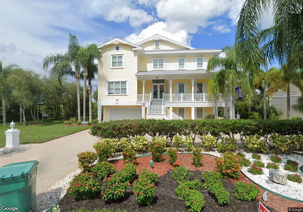
1027 Point Seaside Dr Crystal Beach, FL 34681
Estimated Value: $949,000 - $1,512,000
--
Bed
--
Bath
4,277
Sq Ft
$304/Sq Ft
Est. Value
About This Home
This home is located at 1027 Point Seaside Dr, Crystal Beach, FL 34681 and is currently estimated at $1,300,540, approximately $304 per square foot. 1027 Point Seaside Dr is a home with nearby schools including Ozona Elementary School, Palm Harbor Middle School, and Palm Harbor University High.
Ownership History
Date
Name
Owned For
Owner Type
Purchase Details
Closed on
Dec 3, 1997
Sold by
Adams Robert C and Adams Tami L
Bought by
Folkman Carl E and Folkman Ellen M
Current Estimated Value
Purchase Details
Closed on
Sep 12, 1994
Sold by
Dillon John M and Dillon Lillian Walker
Bought by
Adams Robert C and Adams Tami L
Create a Home Valuation Report for This Property
The Home Valuation Report is an in-depth analysis detailing your home's value as well as a comparison with similar homes in the area
Home Values in the Area
Average Home Value in this Area
Purchase History
| Date | Buyer | Sale Price | Title Company |
|---|---|---|---|
| Folkman Carl E | $82,000 | -- | |
| Adams Robert C | $69,500 | -- |
Source: Public Records
Mortgage History
| Date | Status | Borrower | Loan Amount |
|---|---|---|---|
| Open | Folkman Carl E | $50,000 | |
| Closed | Folkman Carl E | $30,000 | |
| Open | Folkman Carl E | $494,000 |
Source: Public Records
Tax History Compared to Growth
Tax History
| Year | Tax Paid | Tax Assessment Tax Assessment Total Assessment is a certain percentage of the fair market value that is determined by local assessors to be the total taxable value of land and additions on the property. | Land | Improvement |
|---|---|---|---|---|
| 2024 | $12,477 | $750,934 | -- | -- |
| 2023 | $12,477 | $729,062 | $0 | $0 |
| 2022 | $12,169 | $707,827 | $0 | $0 |
| 2021 | $12,352 | $687,211 | $0 | $0 |
| 2020 | $12,342 | $677,723 | $0 | $0 |
| 2019 | $12,157 | $662,486 | $0 | $0 |
| 2018 | $12,016 | $650,133 | $0 | $0 |
| 2017 | $12,128 | $646,341 | $0 | $0 |
| 2016 | $12,050 | $633,047 | $0 | $0 |
| 2015 | $12,234 | $628,646 | $0 | $0 |
| 2014 | $12,332 | $623,657 | $0 | $0 |
Source: Public Records
Map
Nearby Homes
- 1087 Point Seaside Dr
- 0 Point Seaside Dr Unit MFRTB8313583
- 0 Osprey Ct Unit MFRTB8366398
- 0 Seaview Dr Unit MFRTB8428721
- 363 Sanctuary Dr
- 405 Charleston Ave
- 410 Georgia Ave
- 408 Georgia Ave
- 394 Georgia Ave
- 402 Orchid Ln
- 602 Mccosh Ave
- 412 Orchid Ln
- 135 Florida Blvd
- 378 Tennessee Ave
- 606 Indiana Ave
- 12 Bayou Ln
- 350 Kentucky Ave
- 416 Indiana Ave
- 614 Betmor Ln
- 763 Jacqueline Ln
- 1015 Point Seaside Dr
- 1039 Point Seaside Dr
- 1026 Point Seaside Dr
- 1038 Point Seaside Dr
- 1050 Point Seaside Dr
- 989 Point Seaside Dr
- 1063 Point Seaside Dr
- 1014 Point Seaside Dr
- 1062 Point Seaside Dr
- 977 Point Seaside Dr
- 1002 Point Seaside Dr
- 1075 Point Seaside Dr
- 990 Point Seaside Dr
- 1074 Point Seaside Dr
- 965 Point Seaside Dr
- 978 Point Seaside Dr
- 1086 Point Seaside Dr
- 953 Point Seaside Dr
- 966 Point Seaside Dr
- 1099 Point Seaside Dr