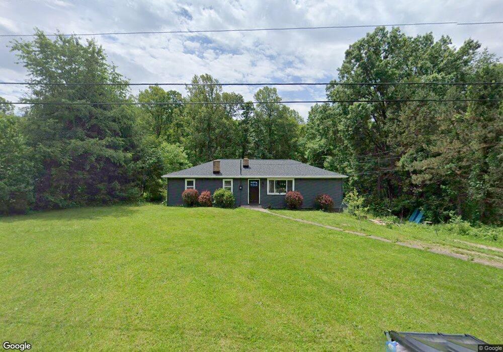
10270 Stoneacre St NW Canal Fulton, OH 44614
Estimated Value: $86,000 - $215,000
2
Beds
1
Bath
1,372
Sq Ft
$119/Sq Ft
Est. Value
About This Home
This home is located at 10270 Stoneacre St NW, Canal Fulton, OH 44614 and is currently estimated at $163,046, approximately $118 per square foot. 10270 Stoneacre St NW is a home located in Stark County with nearby schools including W.S. Stinson Elementary School, Northwest Primary School, and Northwest Middle School.
Ownership History
Date
Name
Owned For
Owner Type
Purchase Details
Closed on
May 7, 2010
Sold by
Us Bank National Association
Bought by
Allen Michael A and Allen Kristi N
Current Estimated Value
Purchase Details
Closed on
Jan 6, 2010
Sold by
Wells William T and Wells William T
Bought by
Us Bank National Association
Purchase Details
Closed on
Oct 28, 1996
Sold by
Arthur William L
Bought by
Wells William T and Wells William
Create a Home Valuation Report for This Property
The Home Valuation Report is an in-depth analysis detailing your home's value as well as a comparison with similar homes in the area
Home Values in the Area
Average Home Value in this Area
Purchase History
| Date | Buyer | Sale Price | Title Company |
|---|---|---|---|
| Allen Michael A | $27,000 | Accutitle Agency Inc | |
| Us Bank National Association | $36,000 | None Available | |
| Wells William T | $16,000 | -- |
Source: Public Records
Tax History Compared to Growth
Tax History
| Year | Tax Paid | Tax Assessment Tax Assessment Total Assessment is a certain percentage of the fair market value that is determined by local assessors to be the total taxable value of land and additions on the property. | Land | Improvement |
|---|---|---|---|---|
| 2025 | -- | $24,400 | $18,340 | $6,060 |
| 2024 | -- | $24,400 | $18,340 | $6,060 |
| 2023 | $1,234 | $27,130 | $14,560 | $12,570 |
| 2022 | $1,236 | $27,130 | $14,560 | $12,570 |
| 2021 | $1,239 | $27,130 | $14,560 | $12,570 |
| 2020 | $1,111 | $21,740 | $11,730 | $10,010 |
| 2019 | $1,123 | $21,740 | $11,730 | $10,010 |
| 2018 | $1,098 | $21,740 | $11,730 | $10,010 |
| 2017 | $1,007 | $18,900 | $10,010 | $8,890 |
| 2016 | $1,012 | $18,900 | $10,010 | $8,890 |
| 2015 | $1,003 | $18,690 | $10,010 | $8,680 |
| 2014 | $941 | $16,180 | $8,650 | $7,530 |
| 2013 | $466 | $16,180 | $8,650 | $7,530 |
Source: Public Records
Map
Nearby Homes
- 10400 Strausser St NW
- 7509 Galena Ave NW
- 9725 Diamond Ridge Cir NW
- 9729 Emerald Hill St NW
- 9756 Strausser St NW
- 6764 Silver Leaf Ave NW
- 9671 Beryl St NW
- 7479 Montella Ave NW
- 7596 Montella Ave NW
- 0 High Mill Ave NW
- 10778 Yare Cir NW
- 7601 Lutz Ave NW
- 9315 Paulding St NW
- 8801 Willingham Dr NW
- 7040 Lutz Ave NW
- 8932 Franklin St NW
- 8817 Willingham Dr NW
- 9042 Wolocott St NW
- 8853 Franklin St NW
- Asheville Plan at Heritage Park
- 10246 Stoneacre St NW
- 10286 Stoneacre St NW
- 10230 Stoneacre St NW
- 10306 Stoneacre St NW
- 7474 Arthur Ave NW
- 10206 Stoneacre St NW
- 7501 Brownwood Ave NW
- 10330 Stoneacre St NW
- 7500 Arthur Ave NW
- 7514 Arthur Ave NW
- 7475 Arthur Ave NW
- 7521 Brownwood Ave NW
- 7382 Akron Ave NW
- 7499 Arthur Ave NW
- 10350 Stoneacre St NW
- 7534 Arthur Ave NW
- 7484 Brownwood Ave NW
- 7519 Arthur Ave NW
- 7539 Brownwood Ave NW
- 10366 Stoneacre St NW