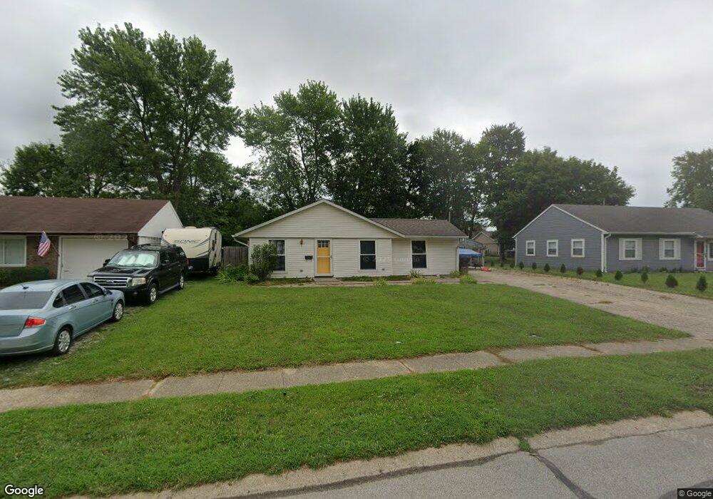
1029 Ashland Ave Whiteland, IN 46184
Estimated Value: $194,408 - $207,000
3
Beds
1
Bath
1,107
Sq Ft
$183/Sq Ft
Est. Value
About This Home
This home is located at 1029 Ashland Ave, Whiteland, IN 46184 and is currently estimated at $202,102, approximately $182 per square foot. 1029 Ashland Ave is a home located in Johnson County with nearby schools including Break-O-Day Elementary School, Clark-Pleasant Middle School, and Whiteland Community High School.
Ownership History
Date
Name
Owned For
Owner Type
Purchase Details
Closed on
May 28, 2005
Sold by
Brawand Robert L and Brawand Charlie E
Bought by
Brawand Charlie E
Current Estimated Value
Home Financials for this Owner
Home Financials are based on the most recent Mortgage that was taken out on this home.
Original Mortgage
$87,300
Interest Rate
6.5%
Mortgage Type
Adjustable Rate Mortgage/ARM
Create a Home Valuation Report for This Property
The Home Valuation Report is an in-depth analysis detailing your home's value as well as a comparison with similar homes in the area
Home Values in the Area
Average Home Value in this Area
Purchase History
| Date | Buyer | Sale Price | Title Company |
|---|---|---|---|
| Brawand Charlie E | -- | Towne And Country Land Title |
Source: Public Records
Mortgage History
| Date | Status | Borrower | Loan Amount |
|---|---|---|---|
| Closed | Brawand Charlie E | $87,300 |
Source: Public Records
Tax History Compared to Growth
Tax History
| Year | Tax Paid | Tax Assessment Tax Assessment Total Assessment is a certain percentage of the fair market value that is determined by local assessors to be the total taxable value of land and additions on the property. | Land | Improvement |
|---|---|---|---|---|
| 2025 | $1,274 | $150,400 | $42,000 | $108,400 |
| 2024 | $1,274 | $143,600 | $42,000 | $101,600 |
| 2023 | $1,341 | $138,000 | $42,000 | $96,000 |
| 2022 | $1,227 | $126,500 | $35,000 | $91,500 |
| 2021 | $1,073 | $112,700 | $35,000 | $77,700 |
| 2020 | $784 | $88,100 | $23,500 | $64,600 |
| 2019 | $673 | $81,400 | $17,900 | $63,500 |
| 2018 | $651 | $79,700 | $15,100 | $64,600 |
| 2017 | $641 | $78,700 | $15,100 | $63,600 |
| 2016 | $498 | $75,900 | $15,100 | $60,800 |
| 2014 | $469 | $69,700 | $15,300 | $54,400 |
| 2013 | $469 | $71,200 | $15,300 | $55,900 |
Source: Public Records
Map
Nearby Homes
- 53 Oakden Ct
- 57 Oakden Ct
- 190 Tracy Ridge Blvd
- 143 Tracy Ridge Blvd
- 106 Tracy Ridge Blvd
- 256 Bittersweet Dr
- 6540 N Us Highway 31
- 1119 Chateaugay Ct
- 638 Harvest Meadow Way
- 840 Sweetbriar Ave
- 821 Princeton Dr
- 250 Southlane Dr
- 50 Meadow Creek Blvd
- 1041 Mount Olive Rd
- 559 Genisis Dr
- 111 Meadow Creek Blvd
- 0 E 700 N Unit MBR22036500
- 624 Sweetbriar Ave
- 539 Delbrook Dr
- 12 Rypma Row
- 1031 Ashland Ave
- 1027 Ashland Ave
- 1036 Warwick Rd
- 1034 Warwick Rd
- 1038 Warwick Rd
- 1033 Ashland Ave
- 1025 Ashland Ave
- 1034 Warwick Dr
- 1028 Ashland Ave
- 1040 Warwick Rd
- 1032 Warwick Rd
- 1030 Ashland Ave
- 1026 Ashland Ave
- 1035 Ashland Ave
- 1023 Ashland Ave
- 1032 Ashland Ave
- 1024 Ashland Ave
- 1042 Warwick Rd
- 1030 Warwick Rd
- 1034 Ashland Ave