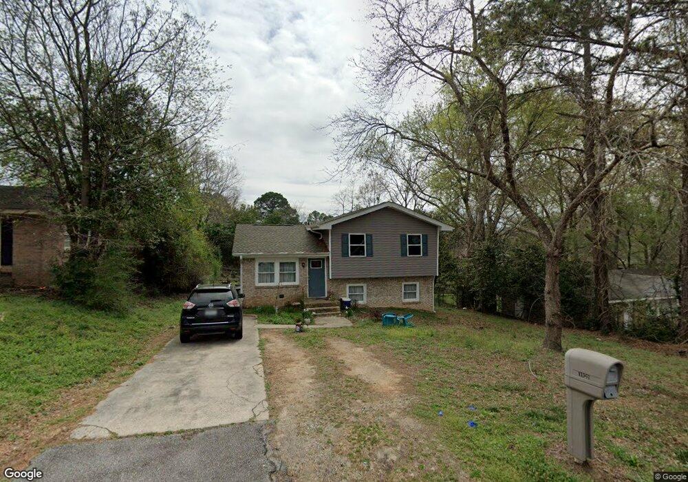
1029 Dawson Dr West Columbia, SC 29169
Estimated Value: $179,000 - $225,586
3
Beds
2
Baths
1,498
Sq Ft
$130/Sq Ft
Est. Value
About This Home
This home is located at 1029 Dawson Dr, West Columbia, SC 29169 and is currently estimated at $195,147, approximately $130 per square foot. 1029 Dawson Dr is a home located in Lexington County with nearby schools including Riverbank Elementary, Northside Middle, and Brookland-Cayce High School.
Ownership History
Date
Name
Owned For
Owner Type
Purchase Details
Closed on
Sep 22, 2020
Sold by
Verne Brunson Taylor
Bought by
Jones Daniel and Jones Kimberly F
Current Estimated Value
Home Financials for this Owner
Home Financials are based on the most recent Mortgage that was taken out on this home.
Original Mortgage
$132,554
Outstanding Balance
$117,633
Interest Rate
2.9%
Mortgage Type
FHA
Estimated Equity
$77,514
Purchase Details
Closed on
Oct 31, 2019
Sold by
Bank Of America Na
Bought by
Brunson Taylor Verne
Purchase Details
Closed on
Sep 30, 2019
Sold by
Lewis Troy F
Bought by
Bank Of America Na
Create a Home Valuation Report for This Property
The Home Valuation Report is an in-depth analysis detailing your home's value as well as a comparison with similar homes in the area
Home Values in the Area
Average Home Value in this Area
Purchase History
| Date | Buyer | Sale Price | Title Company |
|---|---|---|---|
| Jones Daniel | $135,000 | Moran Christopher J | |
| Brunson Taylor Verne | $71,400 | Servicelink Llc | |
| Bank Of America Na | $40,000 | None Available |
Source: Public Records
Mortgage History
| Date | Status | Borrower | Loan Amount |
|---|---|---|---|
| Open | Jones Daniel | $132,554 |
Source: Public Records
Tax History Compared to Growth
Tax History
| Year | Tax Paid | Tax Assessment Tax Assessment Total Assessment is a certain percentage of the fair market value that is determined by local assessors to be the total taxable value of land and additions on the property. | Land | Improvement |
|---|---|---|---|---|
| 2024 | $765 | $5,400 | $1,000 | $4,400 |
| 2023 | $765 | $5,400 | $1,000 | $4,400 |
| 2022 | $765 | $5,400 | $1,000 | $4,400 |
| 2020 | $506 | $5,388 | $1,500 | $3,888 |
| 2019 | $455 | $3,160 | $800 | $2,360 |
| 2018 | $461 | $3,160 | $800 | $2,360 |
| 2017 | $444 | $3,160 | $800 | $2,360 |
| 2016 | $456 | $3,160 | $800 | $2,360 |
| 2014 | $351 | $3,563 | $520 | $3,043 |
| 2013 | -- | $3,560 | $520 | $3,040 |
Source: Public Records
Map
Nearby Homes
- 108 Wismar St
- 114 Wismar St
- 229 Laurel Meadows Dr
- 38 Shadowfield Dr
- 238 Cromer Rd
- 105 Agape Village Ct
- 509 Chisolm Way
- 311 Duchess Trail
- 111 Crepe Myrtle Cir
- 187 Golden Pond Dr
- 184 Lott Ct
- 205 Mansfield Cir
- 149 Mansfield Cir
- 213 Mansfield Cir
- 240 Saluda Woods Place
- 291 Big Timber Dr
- 122 Mansfield Cir
- 0 Mossborough Dr
- 101 Tarawood Dr
- 228 Ashmore Ln
- 1033 Dawson Dr
- 1027 Dawson Dr
- 1018 Kingsberry Terrace
- 1037 Dawson Dr
- 1023 Dawson Dr
- 1016 Kingsberry Terrace
- 1020 Kingsberry Terrace
- 1030 Dawson Dr
- 1034 Dawson Dr
- 1024 Kingsberry Terrace
- 1014 Kingsberry Terrace
- 1039 Dawson Dr
- 1019 Dawson Dr
- 1036 Dawson Dr
- 1026 Dawson Dr
- 1026 Kingsberry Terrace
- 1038 Dawson Dr
- 1015 Dawson Dr
- 1012 Kingsberry Terrace
- 101 Lander Dr