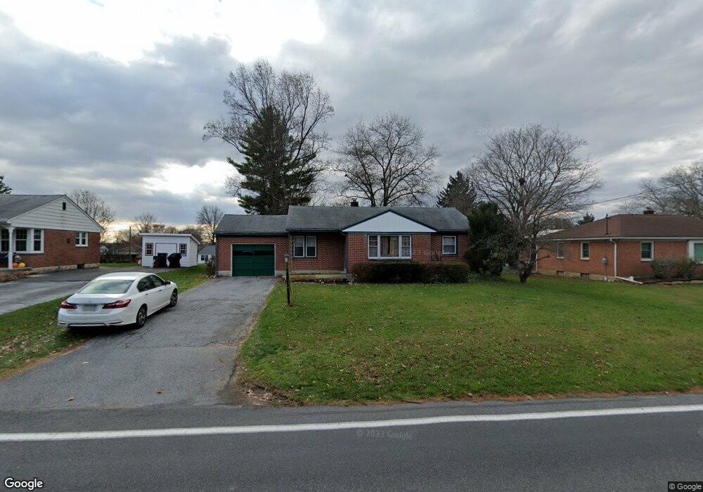
1029 S Forge Rd Palmyra, PA 17078
Estimated Value: $270,000 - $324,000
3
Beds
2
Baths
1,014
Sq Ft
$286/Sq Ft
Est. Value
About This Home
This home is located at 1029 S Forge Rd, Palmyra, PA 17078 and is currently estimated at $290,108, approximately $286 per square foot. 1029 S Forge Rd is a home located in Lebanon County with nearby schools including Palmyra Area Senior High School and St. Joan of Arc Elementary School.
Ownership History
Date
Name
Owned For
Owner Type
Purchase Details
Closed on
Jul 12, 2024
Sold by
Lwanga Shem K and Kisekka Norah B
Bought by
Kisekka Kenneth Kiyimba and Nabacwa Barbara G
Current Estimated Value
Create a Home Valuation Report for This Property
The Home Valuation Report is an in-depth analysis detailing your home's value as well as a comparison with similar homes in the area
Home Values in the Area
Average Home Value in this Area
Purchase History
| Date | Buyer | Sale Price | Title Company |
|---|---|---|---|
| Kisekka Kenneth Kiyimba | $212,500 | None Listed On Document |
Source: Public Records
Tax History Compared to Growth
Tax History
| Year | Tax Paid | Tax Assessment Tax Assessment Total Assessment is a certain percentage of the fair market value that is determined by local assessors to be the total taxable value of land and additions on the property. | Land | Improvement |
|---|---|---|---|---|
| 2025 | $3,598 | $146,500 | $42,000 | $104,500 |
| 2024 | $3,334 | $146,500 | $42,000 | $104,500 |
| 2023 | $3,334 | $146,500 | $42,000 | $104,500 |
| 2022 | $3,248 | $146,500 | $42,000 | $104,500 |
| 2021 | $3,069 | $146,500 | $42,000 | $104,500 |
| 2020 | $3,027 | $146,500 | $42,000 | $104,500 |
| 2019 | $2,968 | $146,500 | $42,000 | $104,500 |
| 2018 | $2,937 | $146,500 | $42,000 | $104,500 |
| 2017 | $778 | $146,500 | $42,000 | $104,500 |
| 2016 | $2,747 | $146,500 | $42,000 | $104,500 |
| 2015 | -- | $146,500 | $42,000 | $104,500 |
| 2014 | -- | $146,500 | $42,000 | $104,500 |
Source: Public Records
Map
Nearby Homes
- 1027 S Green St
- 1160 Park Dr
- 1325 Mill Pond Way
- 203 S Harrison St
- 925 E Oak St
- 425 E Maple St
- 322 E Cherry St
- 914 E Cherry St
- 128 E Main St
- 21 Saratoga Run L-0121 Run
- 11 Wickerberry Ln
- 40 N Grant St
- 223 S Locust St
- 324 W Orchard Dr
- 136 N Penn St
- 18 Hartford Dr
- 22 Lexington Dr
- Sullivan Plan at Summer Layne
- Berkley Plan at Summer Layne
- Charlotte Plan at Summer Layne
- 1041 S Forge Rd
- 1021 S Forge Rd
- 1049 S Forge Rd
- 1026 S Green St
- 1040 S Green St
- 1012 S Green St
- 961 S Forge Rd
- 1059 S Forge Rd
- 1054 S Green St
- 1030 S Forge Rd
- 1020 S Forge Rd
- 1040 S Forge Rd
- 980 S Green St
- 0 S Forge Rd Unit PALN2019564
- 951 S Forge Rd
- 1068 S Green St
- 1069 S Forge Rd
- 970 S Forge Rd
- 1060 S Forge Rd
- 960 S Green St