Estimated Value: $306,586 - $767,000
--
Bed
--
Bath
--
Sq Ft
0.3
Acres
About This Home
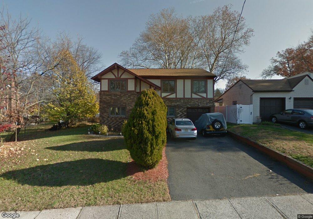
This home is located at 1029 Sayre Rd, Union, NJ 07083 and is currently estimated at $636,647. 1029 Sayre Rd is a home located in Union County with nearby schools including Livingston Elementary School, Union High School, and St Michael Parish School.
Ownership History
Date
Name
Owned For
Owner Type
Purchase Details
Closed on
Oct 25, 2000
Sold by
Raimondo Anthony and Raimondo Albert
Bought by
Andersonn Martha
Current Estimated Value
Home Financials for this Owner
Home Financials are based on the most recent Mortgage that was taken out on this home.
Original Mortgage
$190,000
Outstanding Balance
$69,661
Interest Rate
7.81%
Mortgage Type
Stand Alone First
Estimated Equity
$566,986
Create a Home Valuation Report for This Property
The Home Valuation Report is an in-depth analysis detailing your home's value as well as a comparison with similar homes in the area
Home Values in the Area
Average Home Value in this Area
Purchase History
| Date | Buyer | Sale Price | Title Company |
|---|---|---|---|
| Andersonn Martha | $240,000 | -- |
Source: Public Records
Mortgage History
| Date | Status | Borrower | Loan Amount |
|---|---|---|---|
| Open | Andersonn Martha | $190,000 |
Source: Public Records
Tax History Compared to Growth
Tax History
| Year | Tax Paid | Tax Assessment Tax Assessment Total Assessment is a certain percentage of the fair market value that is determined by local assessors to be the total taxable value of land and additions on the property. | Land | Improvement |
|---|---|---|---|---|
| 2025 | $14,103 | $63,100 | $21,900 | $41,200 |
| 2024 | $13,673 | $63,100 | $21,900 | $41,200 |
| 2023 | $13,673 | $63,100 | $21,900 | $41,200 |
| 2022 | $13,198 | $63,100 | $21,900 | $41,200 |
| 2021 | $12,878 | $63,100 | $21,900 | $41,200 |
| 2020 | $12,621 | $63,100 | $21,900 | $41,200 |
| 2019 | $12,452 | $63,100 | $21,900 | $41,200 |
| 2018 | $12,240 | $63,100 | $21,900 | $41,200 |
| 2017 | $12,058 | $63,100 | $21,900 | $41,200 |
| 2016 | $11,764 | $63,100 | $21,900 | $41,200 |
| 2015 | $11,569 | $63,100 | $21,900 | $41,200 |
| 2014 | $11,310 | $63,100 | $21,900 | $41,200 |
Source: Public Records
Map
Nearby Homes
- 1040 Cranbrook Rd
- 1370 Beverly Rd
- 1267 Erhardt St
- 1393 Cornell Place
- 1322 Marcella Dr
- 365 Broadwell Ave
- 142 Eastern Pkwy
- 286 Mclean Place
- 631 Golf Terrace
- 875 Salem Rd
- 969 Arnet Ave
- 328 Minute Arms Rd
- 553 Harvard Ave
- 557 Yale Ave
- 617 Tillman St
- 112 Apple Tree Ln
- 1848 Portsmouth Way
- 152 Glenwood Ct
- 507 Locust Ave
- 795 Colonial Arms Rd
- 1037 Sayre Rd
- 1531 Brookside Dr
- 1527 Brookside Dr
- 1514 Union County Pkwy
- 1523 Brookside Dr
- 1519 Brookside Dr
- 1045 Sayre Rd
- 1510 Union County Pkwy
- 1024 Sayre Rd
- 1030 Sayre Rd
- 1034 Sayre Rd
- 1038 Sayre Rd
- 1515 Brookside Dr
- 1020 Sayre Rd
- 1506 Union County Pkwy
- 1040 Sayre Rd
- 1526 Brookside Dr
- 1520 Brookside Dr
- 1014 Sayre Rd
- 1047 Sayre Rd