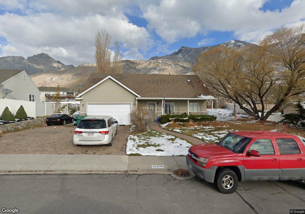
10290 N 3900 W Unit 8 Pleasant Grove, UT 84062
Estimated Value: $687,000 - $781,750
--
Bed
4
Baths
2,043
Sq Ft
$361/Sq Ft
Est. Value
About This Home
This home is located at 10290 N 3900 W Unit 8, Pleasant Grove, UT 84062 and is currently estimated at $737,438, approximately $360 per square foot. 10290 N 3900 W Unit 8 is a home located in Utah County with nearby schools including Cedar Ridge Elementary School, Mountain Ridge Junior High School, and Lone Peak High School.
Ownership History
Date
Name
Owned For
Owner Type
Purchase Details
Closed on
Apr 11, 2024
Sold by
Colledge Joseph
Bought by
Joseph D And Jacqueline P Colledge Revocable and Colledge
Current Estimated Value
Purchase Details
Closed on
Jan 23, 2013
Sold by
Torriente William Edward and Torriente Gil M
Bought by
Colledge Matthew D and Colledge Joseph
Home Financials for this Owner
Home Financials are based on the most recent Mortgage that was taken out on this home.
Original Mortgage
$245,373
Interest Rate
3.25%
Mortgage Type
FHA
Purchase Details
Closed on
Dec 16, 2010
Sold by
Torriente William Edward and Torriente Gil Mariana
Bought by
Torriente William Edward and Torriente Gil M
Purchase Details
Closed on
Sep 13, 2005
Sold by
G & B Real Estate Holdings
Bought by
Torriente William Edward and Torriente Gill Mariana
Home Financials for this Owner
Home Financials are based on the most recent Mortgage that was taken out on this home.
Original Mortgage
$47,200
Interest Rate
5.81%
Mortgage Type
Fannie Mae Freddie Mac
Purchase Details
Closed on
Jan 11, 2005
Sold by
Bradshaw Casey
Bought by
G & B Real Estate Holdings Llc
Home Financials for this Owner
Home Financials are based on the most recent Mortgage that was taken out on this home.
Original Mortgage
$32,100
Interest Rate
5.67%
Mortgage Type
Credit Line Revolving
Purchase Details
Closed on
Jan 7, 2005
Sold by
Miner Kevin G
Bought by
Bradshaw Casey
Home Financials for this Owner
Home Financials are based on the most recent Mortgage that was taken out on this home.
Original Mortgage
$32,100
Interest Rate
5.67%
Mortgage Type
Credit Line Revolving
Purchase Details
Closed on
Aug 5, 1999
Sold by
Americraft Homes Inc
Bought by
Miner Kevin G
Home Financials for this Owner
Home Financials are based on the most recent Mortgage that was taken out on this home.
Original Mortgage
$171,000
Interest Rate
7.63%
Mortgage Type
Balloon
Create a Home Valuation Report for This Property
The Home Valuation Report is an in-depth analysis detailing your home's value as well as a comparison with similar homes in the area
Home Values in the Area
Average Home Value in this Area
Purchase History
| Date | Buyer | Sale Price | Title Company |
|---|---|---|---|
| Joseph D And Jacqueline P Colledge Revocable | -- | None Listed On Document | |
| Colledge Matthew D | -- | None Available | |
| Torriente William Edward | -- | None Available | |
| Torriente William Edward | -- | None Available | |
| Torriente William Edward | -- | Guardian Title Company Of U | |
| G & B Real Estate Holdings Llc | -- | Guardian Title Company Of U | |
| Bradshaw Casey | -- | Guardian Title Company Of U | |
| Miner Kevin G | -- | Pro Title & Escrow Inc |
Source: Public Records
Mortgage History
| Date | Status | Borrower | Loan Amount |
|---|---|---|---|
| Previous Owner | Colledge Matthew D | $245,373 | |
| Previous Owner | Torriente William Edward | $47,200 | |
| Previous Owner | Torriente William Edward | $188,800 | |
| Previous Owner | Bradshaw Casey | $32,100 | |
| Previous Owner | G & B Real Estate Holdings Llc | $171,350 | |
| Previous Owner | Bradshaw Casey | $171,350 | |
| Previous Owner | Miner Kevin G | $171,000 |
Source: Public Records
Tax History Compared to Growth
Tax History
| Year | Tax Paid | Tax Assessment Tax Assessment Total Assessment is a certain percentage of the fair market value that is determined by local assessors to be the total taxable value of land and additions on the property. | Land | Improvement |
|---|---|---|---|---|
| 2025 | $3,083 | $397,210 | $354,200 | $368,000 |
| 2024 | $3,083 | $365,090 | $0 | $0 |
| 2023 | $2,834 | $360,580 | $0 | $0 |
| 2022 | $2,976 | $369,930 | $0 | $0 |
| 2021 | $2,666 | $493,600 | $230,300 | $263,300 |
| 2020 | $2,481 | $448,300 | $213,200 | $235,100 |
| 2019 | $2,321 | $435,500 | $200,400 | $235,100 |
| 2018 | $2,306 | $407,600 | $200,400 | $207,200 |
| 2017 | $2,244 | $212,080 | $0 | $0 |
| 2016 | $2,292 | $201,465 | $0 | $0 |
| 2015 | $2,257 | $187,770 | $0 | $0 |
| 2014 | $2,068 | $170,885 | $0 | $0 |
Source: Public Records
Map
Nearby Homes
- 10412 N Bayhill Dr
- 10358 N Tamarack Way
- 10514 N Doral Dr
- 10456 N Morgan Blvd
- 10448 Sage Vista Ln
- 10468 N Sage Vista Ln
- 10587 N Avalon St
- 4198 W Sage Rd N
- 3870 Mountaintop Cir
- 4292 W Joshua Ln
- 4083 W Hayes Cir
- 3851 W Mountaintop Cir Unit 5
- 10207 N Cottonwood Dr
- 4084 W Shinnecock
- 10795 N La Costa
- 9900 N Meadow Dr
- 4124 N 810 W
- 4616 W Carriage Ln
- 9752 N Dorchester Dr
- 9575 Aztec Dr
- 10290 N 3900 W
- 10280 N 3900 W
- 10280 N 3900 W Unit 7
- 10302 N 3900 W
- 10300 N 3900 W
- 10300 N 3900 W Unit 9
- 3923 W 10400 N
- 3923 W 10400 N Unit 1
- 10270 N 3900 W
- 10270 N 3900 W Unit 6
- 10275 N 3900 W
- 3928 W 10340 N
- 3928 W 10340 N Unit 10
- 3933 W 10400 N
- 10262 N 3900 W
- 3957 W 10340 N
- 10263 N 3900 W
- 3937 W 10300 N
- 3937 W 10300 N Unit 15
- 3948 W 10340 N