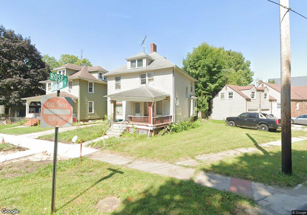
103 Harrison St La Porte, IN 46350
Estimated Value: $78,000 - $193,000
2
Beds
2
Baths
1,640
Sq Ft
$90/Sq Ft
Est. Value
About This Home
This home is located at 103 Harrison St, La Porte, IN 46350 and is currently estimated at $147,213, approximately $89 per square foot. 103 Harrison St is a home located in LaPorte County with nearby schools including Carver Elementary School, Lincoln Elementary School, and Hailmann Elementary School.
Ownership History
Date
Name
Owned For
Owner Type
Purchase Details
Closed on
Jun 23, 2020
Sold by
Nationstar Mtg Llc
Bought by
Guerrero Jose Antonio
Current Estimated Value
Purchase Details
Closed on
Sep 11, 2019
Sold by
Laporte County Sheriff
Bought by
Nationstar Mtg Llc
Purchase Details
Closed on
Oct 31, 2006
Sold by
Galter Maria and Elliott William A
Bought by
Brown Diane M
Home Financials for this Owner
Home Financials are based on the most recent Mortgage that was taken out on this home.
Original Mortgage
$69,375
Interest Rate
6.45%
Mortgage Type
FHA
Create a Home Valuation Report for This Property
The Home Valuation Report is an in-depth analysis detailing your home's value as well as a comparison with similar homes in the area
Home Values in the Area
Average Home Value in this Area
Purchase History
| Date | Buyer | Sale Price | Title Company |
|---|---|---|---|
| Guerrero Jose Antonio | $45,200 | Liberty Title & Escrow | |
| Nationstar Mtg Llc | $70,500 | None Available | |
| Brown Diane M | -- | None Available |
Source: Public Records
Mortgage History
| Date | Status | Borrower | Loan Amount |
|---|---|---|---|
| Previous Owner | Brown Diane M | $69,375 |
Source: Public Records
Tax History Compared to Growth
Tax History
| Year | Tax Paid | Tax Assessment Tax Assessment Total Assessment is a certain percentage of the fair market value that is determined by local assessors to be the total taxable value of land and additions on the property. | Land | Improvement |
|---|---|---|---|---|
| 2024 | $79 | $43,900 | $10,400 | $33,500 |
| 2022 | $40 | $45,700 | $8,600 | $37,100 |
| 2021 | $1,120 | $44,000 | $8,600 | $35,400 |
| 2020 | $1,041 | $44,000 | $8,600 | $35,400 |
| 2019 | $1,060 | $101,200 | $9,300 | $91,900 |
| 2018 | $954 | $90,600 | $7,400 | $83,200 |
| 2017 | $952 | $90,400 | $7,400 | $83,000 |
| 2016 | $984 | $93,600 | $6,500 | $87,100 |
| 2014 | $857 | $87,700 | $6,500 | $81,200 |
Source: Public Records
Map
Nearby Homes
- 906 Linwood Ave
- 202 Jefferson Ave
- 403 Rose St
- 206 Ohio St
- 107 Lincolnway
- 706 Detroit St
- 330 Virginia Ave
- 413 Jefferson Ave
- 910 Scott St
- 208 Norton St
- 0 Brighton St Unit NRA542345
- 602 Plain St
- 503 Grove St
- 1207 Michigan Ave
- 414 Allen St
- 1025 Indiana Ave
- 807 Division St
- 207 Mccollum St
- 810 Virginia Ave
- 205 Lawrence St