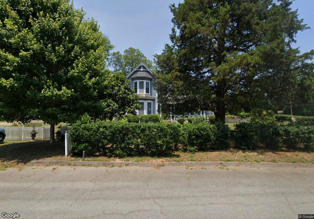
103 High St Eatonton, GA 31024
Estimated Value: $563,000 - $633,000
2
Beds
3
Baths
3,544
Sq Ft
$170/Sq Ft
Est. Value
About This Home
This home is located at 103 High St, Eatonton, GA 31024 and is currently estimated at $604,229, approximately $170 per square foot. 103 High St is a home located in Putnam County with nearby schools including Putnam County Primary School, Putnam County Elementary School, and Putnam County Middle School.
Ownership History
Date
Name
Owned For
Owner Type
Purchase Details
Closed on
Jan 28, 2002
Sold by
Farley Edge R
Bought by
Farley Edge R and Farley Esther S
Current Estimated Value
Purchase Details
Closed on
Jul 19, 1999
Sold by
Farley Edge R
Bought by
Farley Edge R and Farley Esth
Purchase Details
Closed on
Aug 17, 1998
Sold by
Vining Robert W
Bought by
Moore H D
Purchase Details
Closed on
Mar 23, 1992
Sold by
Walker Margaret G
Bought by
Vining Robert W
Create a Home Valuation Report for This Property
The Home Valuation Report is an in-depth analysis detailing your home's value as well as a comparison with similar homes in the area
Home Values in the Area
Average Home Value in this Area
Purchase History
| Date | Buyer | Sale Price | Title Company |
|---|---|---|---|
| Farley Edge R | -- | -- | |
| Farley Edge R | -- | -- | |
| Farley Edge R | $75,000 | -- | |
| Moore H D | $57,500 | -- | |
| Vining Robert W | $3,000 | -- |
Source: Public Records
Tax History Compared to Growth
Tax History
| Year | Tax Paid | Tax Assessment Tax Assessment Total Assessment is a certain percentage of the fair market value that is determined by local assessors to be the total taxable value of land and additions on the property. | Land | Improvement |
|---|---|---|---|---|
| 2024 | $5,141 | $251,349 | $6,000 | $245,349 |
| 2023 | $5,141 | $188,910 | $6,000 | $182,910 |
| 2022 | $5,214 | $222,156 | $6,000 | $216,156 |
| 2021 | $4,621 | $169,313 | $8,481 | $160,832 |
| 2020 | $4,840 | $168,410 | $8,928 | $159,482 |
| 2019 | $4,592 | $141,281 | $8,928 | $132,353 |
| 2018 | $4,299 | $143,417 | $9,820 | $133,597 |
| 2017 | $4,035 | $141,281 | $8,928 | $132,353 |
| 2016 | $4,038 | $141,281 | $8,928 | $132,353 |
| 2015 | $1,986 | $84,560 | $8,928 | $75,632 |
| 2014 | $2,039 | $84,560 | $8,928 | $75,632 |
Source: Public Records
Map
Nearby Homes
- 0 Phillips Dr Unit 67007
- 409 N Jefferson Ave
- 300 E Magnolia St
- 300 Carriage Way
- 194 Phillips Dr
- 204 N Madison Ave
- 307 Wayne St
- 113 N Jefferson Ave
- 156 Anchor Pointe
- 116 SE Hazelwood Dr
- 338 Anchor Pointe
- 105 Brookwood Dr
- 104 Blackberry Ln
- 106 Putnam Ave
- 110 Westminster Dr
- 157 Overlook Dr
- 139 Overlook Dr
- 104 High St
- 500 N Jefferson Ave
- 108 High St
- 323 N Maple Ave
- 502 N Jefferson Ave
- 323 N Maple Ave
- 325 N Maple Ave
- 416 N Jefferson Ave
- 502 N Jefferson Ave
- 325 N Maple Ave
- 318 N Maple Ave
- 0 Maple St N Unit 7036580
- 320 N Maple Ave
- 504 N Jefferson Ave
- 316 N Maple Ave
- 403 N Maple Ave
- 324 N Maple Ave
- 600 N Jefferson Ave
- 501 N Jefferson Ave
- 419 N Jefferson Ave