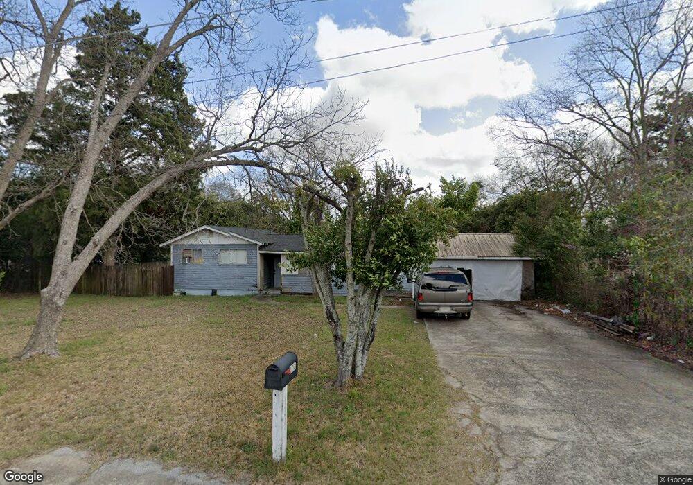
103 Holt Ave Warner Robins, GA 31088
Estimated Value: $78,000 - $166,000
3
Beds
1
Bath
1,076
Sq Ft
$111/Sq Ft
Est. Value
About This Home
This home is located at 103 Holt Ave, Warner Robins, GA 31088 and is currently estimated at $119,759, approximately $111 per square foot. 103 Holt Ave is a home located in Houston County with nearby schools including Miller Elementary School, Warner Robins Middle School, and Warner Robins High School.
Ownership History
Date
Name
Owned For
Owner Type
Purchase Details
Closed on
Jun 3, 2015
Sold by
Bjbs Rentals Llc
Bought by
Flores Estefes Jose Angel
Current Estimated Value
Home Financials for this Owner
Home Financials are based on the most recent Mortgage that was taken out on this home.
Original Mortgage
$19,000
Interest Rate
3.88%
Mortgage Type
New Conventional
Purchase Details
Closed on
Dec 31, 2007
Sold by
Stincer Leisa A Blakely and Blakely Betty Jean
Bought by
Bjbs Rentals Llc
Purchase Details
Closed on
Mar 16, 1992
Sold by
Jordan C C
Bought by
Blakely Betty J
Purchase Details
Closed on
Mar 14, 1961
Sold by
Brady John M
Bought by
Jordan C C
Create a Home Valuation Report for This Property
The Home Valuation Report is an in-depth analysis detailing your home's value as well as a comparison with similar homes in the area
Home Values in the Area
Average Home Value in this Area
Purchase History
| Date | Buyer | Sale Price | Title Company |
|---|---|---|---|
| Flores Estefes Jose Angel | $25,000 | -- | |
| Bjbs Rentals Llc | -- | None Available | |
| Blakely Betty J | -- | None Available | |
| Blakely Betty J | -- | -- | |
| Jordan C C | -- | -- |
Source: Public Records
Mortgage History
| Date | Status | Borrower | Loan Amount |
|---|---|---|---|
| Closed | Flores Estefes Jose Angel | $19,000 |
Source: Public Records
Tax History Compared to Growth
Tax History
| Year | Tax Paid | Tax Assessment Tax Assessment Total Assessment is a certain percentage of the fair market value that is determined by local assessors to be the total taxable value of land and additions on the property. | Land | Improvement |
|---|---|---|---|---|
| 2024 | $317 | $15,240 | $3,800 | $11,440 |
| 2023 | $279 | $13,560 | $3,800 | $9,760 |
| 2022 | $291 | $14,040 | $3,800 | $10,240 |
| 2021 | $254 | $12,440 | $3,800 | $8,640 |
| 2020 | $191 | $9,720 | $3,800 | $5,920 |
| 2019 | $188 | $9,720 | $3,800 | $5,920 |
| 2018 | $188 | $9,720 | $3,800 | $5,920 |
| 2017 | $189 | $9,720 | $3,800 | $5,920 |
| 2016 | $245 | $15,280 | $3,800 | $11,480 |
| 2015 | $375 | $15,280 | $3,800 | $11,480 |
| 2014 | -- | $15,280 | $3,800 | $11,480 |
| 2013 | -- | $15,280 | $3,800 | $11,480 |
Source: Public Records
Map
Nearby Homes
- 112 Holt Ave
- 225 Woodland Trail
- 209 Knodishall Dr
- 301 Millside Dr
- 108 Madison Ave
- 112 Peacock Dr
- 318 Somerset Dr
- 707 Wilmington Dr
- 141 Peacock Dr
- 321 Somerset Dr
- 103 Westcliff Cir Unit A
- 705 Corder Rd
- 111 Hawthorne Rd
- 1728 Green St
- 102 Westcliff Center St Unit D
- 101 Hampstead Ct
- 115 Pershing Place Ct
- 1716 Green St
- 111 Laurel Oak Ln
- 201 Clairmont Dr