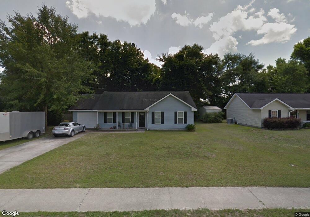
103 Layne Ave Rincon, GA 31326
Estimated Value: $252,000 - $272,000
Studio
1
Bath
1,260
Sq Ft
$209/Sq Ft
Est. Value
About This Home
This home is located at 103 Layne Ave, Rincon, GA 31326 and is currently estimated at $263,136, approximately $208 per square foot. 103 Layne Ave is a home located in Effingham County with nearby schools including Rincon Elementary School, Ebenezer Middle School, and Effingham County High School.
Ownership History
Date
Name
Owned For
Owner Type
Purchase Details
Closed on
Jul 26, 2007
Sold by
Brazell Gary Gene
Bought by
St George Edward
Current Estimated Value
Purchase Details
Closed on
Aug 25, 2006
Sold by
Vandamm Loretta
Bought by
Brazell Gary G
Purchase Details
Closed on
Jan 4, 2005
Sold by
N & J Land Corp Inc
Bought by
Vanvandamm Loretta Van
Home Financials for this Owner
Home Financials are based on the most recent Mortgage that was taken out on this home.
Original Mortgage
$61,958
Interest Rate
5.61%
Mortgage Type
New Conventional
Create a Home Valuation Report for This Property
The Home Valuation Report is an in-depth analysis detailing your home's value as well as a comparison with similar homes in the area
Home Values in the Area
Average Home Value in this Area
Purchase History
| Date | Buyer | Sale Price | Title Company |
|---|---|---|---|
| St George Edward | -- | -- | |
| Brazell Gary G | $124,000 | -- | |
| Vanvandamm Loretta Van | $101,958 | -- |
Source: Public Records
Mortgage History
| Date | Status | Borrower | Loan Amount |
|---|---|---|---|
| Previous Owner | Vanvandamm Loretta Van | $61,958 |
Source: Public Records
Tax History
| Year | Tax Paid | Tax Assessment Tax Assessment Total Assessment is a certain percentage of the fair market value that is determined by local assessors to be the total taxable value of land and additions on the property. | Land | Improvement |
|---|---|---|---|---|
| 2025 | $2,455 | $89,183 | $22,800 | $66,383 |
| 2024 | $2,455 | $90,161 | $22,800 | $67,361 |
| 2023 | $1,852 | $75,986 | $17,600 | $58,386 |
| 2022 | $1,713 | $65,076 | $17,600 | $47,476 |
| 2021 | $1,525 | $57,022 | $14,000 | $43,022 |
| 2020 | $1,576 | $54,131 | $12,000 | $42,131 |
| 2019 | $1,408 | $49,136 | $12,000 | $37,136 |
| 2018 | $1,374 | $49,160 | $10,000 | $39,160 |
| 2017 | $1,372 | $48,364 | $9,560 | $38,804 |
| 2016 | $1,365 | $47,666 | $13,600 | $34,066 |
| 2015 | -- | $41,266 | $7,200 | $34,066 |
| 2014 | -- | $46,066 | $12,000 | $34,066 |
| 2013 | -- | $40,466 | $6,400 | $34,066 |
Source: Public Records
Map
Nearby Homes
- 107 Stonewalk Dr
- 136 Fraser Ln
- 114 Stonewalk Dr
- 211 Quartz Dr
- 112 Karima Cir
- 105 Saint Andrews Rd
- 124 Tolliver Ln
- 811 Walthour Dr
- 219 Jasper Ln
- 201 Walthour Dr
- 233 Jasper Ln
- 202 Walthour Dr
- 512 Windsong Dr
- 414 Roberts Way
- 305 Walthour Dr
- 417 Keiffer Dr
- 204 Pineland Dr
- 427 Seabreeze Dr
- 411 Plantation Place
- 434 Roberts Way
Your Personal Tour Guide
Ask me questions while you tour the home.