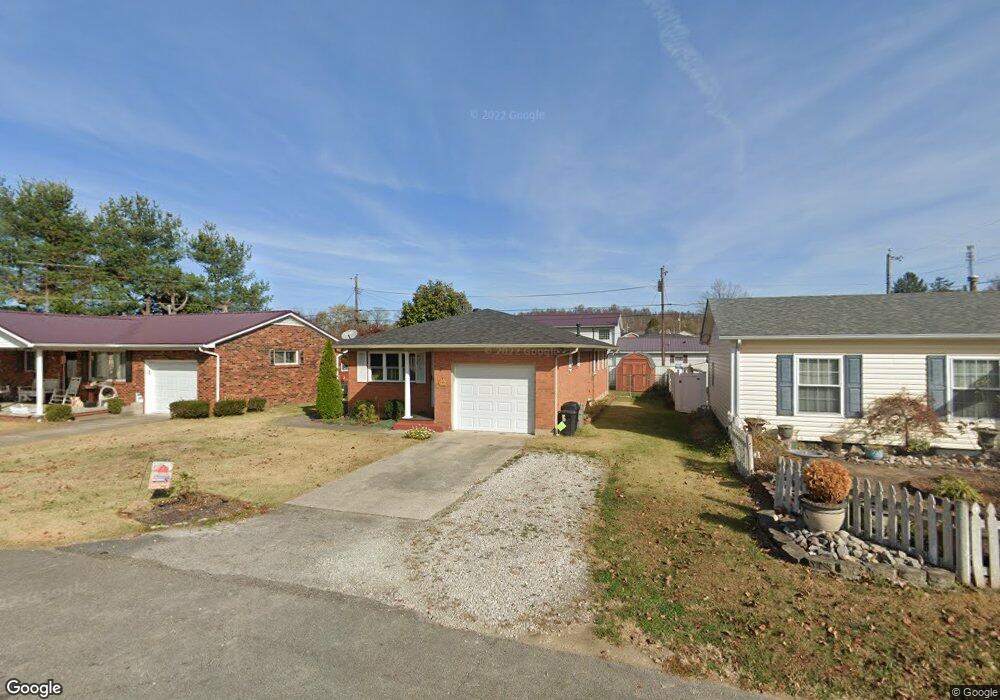
103 Michael St South Point, OH 45680
Estimated Value: $163,000 - $195,000
3
Beds
1
Bath
1,245
Sq Ft
$140/Sq Ft
Est. Value
About This Home
This home is located at 103 Michael St, South Point, OH 45680 and is currently estimated at $173,837, approximately $139 per square foot. 103 Michael St is a home located in Lawrence County with nearby schools including South Point High School.
Ownership History
Date
Name
Owned For
Owner Type
Purchase Details
Closed on
Sep 15, 2023
Sold by
White Betty A
Bought by
Farley Stewart Travis and Farley Stewart Kenneth
Current Estimated Value
Purchase Details
Closed on
Oct 2, 2006
Sold by
Huff Jane P
Bought by
Oates Brondi
Purchase Details
Closed on
Jul 8, 2003
Sold by
Saunders Gary A and Saunders Tre
Bought by
White Betty A
Purchase Details
Closed on
Feb 1, 1999
Sold by
Blake Thomas E and Blake Robin
Bought by
Saunders Gary A and Saunders Tre
Purchase Details
Closed on
Oct 21, 1994
Sold by
Blake Thomas E and Blake Robi
Bought by
Blake Thomas E and Blake Robin
Purchase Details
Closed on
Oct 9, 1992
Sold by
Mckee Ruth
Bought by
Blake Thomas E and Blake Robi
Create a Home Valuation Report for This Property
The Home Valuation Report is an in-depth analysis detailing your home's value as well as a comparison with similar homes in the area
Home Values in the Area
Average Home Value in this Area
Purchase History
| Date | Buyer | Sale Price | Title Company |
|---|---|---|---|
| Farley Stewart Travis | $161,000 | None Listed On Document | |
| Oates Brondi | $10,000 | None Available | |
| White Betty A | $82,500 | -- | |
| Saunders Gary A | $68,000 | -- | |
| Blake Thomas E | $35,500 | -- | |
| Blake Thomas E | $52,500 | -- |
Source: Public Records
Tax History
| Year | Tax Paid | Tax Assessment Tax Assessment Total Assessment is a certain percentage of the fair market value that is determined by local assessors to be the total taxable value of land and additions on the property. | Land | Improvement |
|---|---|---|---|---|
| 2025 | $1,441 | $45,595 | $5,576 | $40,019 |
| 2024 | -- | $38,650 | $4,730 | $33,920 |
| 2023 | $1,361 | $38,650 | $4,730 | $33,920 |
| 2022 | $1,030 | $38,650 | $4,730 | $33,920 |
| 2021 | $914 | $33,830 | $3,990 | $29,840 |
| 2020 | $928 | $33,830 | $3,990 | $29,840 |
| 2019 | $923 | $33,830 | $3,990 | $29,840 |
| 2018 | $827 | $30,750 | $3,620 | $27,130 |
| 2017 | $825 | $30,750 | $3,620 | $27,130 |
| 2016 | $772 | $30,750 | $3,620 | $27,130 |
| 2015 | $579 | $24,150 | $3,620 | $20,530 |
| 2014 | $579 | $24,150 | $3,620 | $20,530 |
| 2013 | $524 | $24,150 | $3,620 | $20,530 |
Source: Public Records
Map
Nearby Homes
- 216 Michael St
- 211 Mason St
- 113 Ashland Dr
- 116 Ashland Dr
- 210 Brubaker Dr
- 107 Ashland Dr
- 114 Ashland Dr
- 106 Garden Ct
- 113 Nelson Ave
- 607 3rd St E
- 0 Orchard Dr Unit Old Farme Subdivisio
- 406 2nd St E
- 102 Park Ave
- 205 Hillview Ln
- 306 2nd St W
- 509 Sharon Ct
- 1907 Walnut St
- 295 Private Road 660 Unit 60
- 1524 Beech St
- 1523 Oak St
- 101 Michael St
- 105 Michael St
- 104 Michael St
- 301 Delores Ave
- 303 Delores Ave
- 506 Brubaker Dr
- 201 Michael St
- 120 Billie Joy Dr
- 102 Michael St
- 118 Billie Joy Dr
- 202 Michael St
- 122 Billie Joy Dr
- 203 Michael St
- 302 Delores Ave
- 304 Delores Ave
- 122 Billie Joy Dr
- 207 Delores Ave
- 116 Billie Joy Dr
- 504 Brubaker Dr
- 508 Brubaker Dr
Your Personal Tour Guide
Ask me questions while you tour the home.