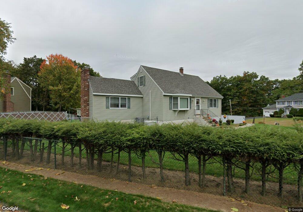
103 Pitman St Methuen, MA 01844
The East End NeighborhoodEstimated Value: $671,064 - $702,000
3
Beds
2
Baths
2,457
Sq Ft
$280/Sq Ft
Est. Value
About This Home
This home is located at 103 Pitman St, Methuen, MA 01844 and is currently estimated at $688,016, approximately $280 per square foot. 103 Pitman St is a home located in Essex County with nearby schools including Methuen High School, Community Day Charter Public School - Gateway, and Esperanza Academy School of Hope.
Ownership History
Date
Name
Owned For
Owner Type
Purchase Details
Closed on
Apr 14, 2016
Sold by
Mugavero Marilyn A
Bought by
Mugavero Rt and Mugavero
Current Estimated Value
Purchase Details
Closed on
Sep 10, 2009
Sold by
Mugavero John J and Mugavero Marilyn A
Bought by
Mugavero Joseph A and Mugavero John J
Create a Home Valuation Report for This Property
The Home Valuation Report is an in-depth analysis detailing your home's value as well as a comparison with similar homes in the area
Home Values in the Area
Average Home Value in this Area
Purchase History
| Date | Buyer | Sale Price | Title Company |
|---|---|---|---|
| Mugavero Rt | -- | -- | |
| Mugavero Rt | -- | -- | |
| Mugavero Rt | -- | -- | |
| Mugavero Joseph A | -- | -- | |
| Mugavero Joseph A | -- | -- |
Source: Public Records
Mortgage History
| Date | Status | Borrower | Loan Amount |
|---|---|---|---|
| Previous Owner | Mugavero Joseph A | $68,000 | |
| Previous Owner | Mugavero Joseph A | $48,000 | |
| Previous Owner | Mugavero Joseph A | $39,000 |
Source: Public Records
Tax History Compared to Growth
Tax History
| Year | Tax Paid | Tax Assessment Tax Assessment Total Assessment is a certain percentage of the fair market value that is determined by local assessors to be the total taxable value of land and additions on the property. | Land | Improvement |
|---|---|---|---|---|
| 2025 | $5,886 | $556,300 | $224,700 | $331,600 |
| 2024 | $5,919 | $545,000 | $205,000 | $340,000 |
| 2023 | $5,513 | $471,200 | $182,200 | $289,000 |
| 2022 | $5,215 | $399,600 | $151,900 | $247,700 |
| 2021 | $4,953 | $375,500 | $144,300 | $231,200 |
| 2020 | $4,958 | $368,900 | $144,300 | $224,600 |
| 2019 | $4,748 | $334,600 | $129,100 | $205,500 |
| 2018 | $4,631 | $324,500 | $129,100 | $195,400 |
| 2017 | $4,457 | $304,200 | $129,100 | $175,100 |
| 2016 | $4,142 | $279,700 | $121,500 | $158,200 |
| 2015 | $3,908 | $267,700 | $121,500 | $146,200 |
Source: Public Records
Map
Nearby Homes
- 66 Newbury Ave
- 29 Pitman St
- 29 Wallace St
- 48 Wingate Ave
- 331 Merrimack St
- 17 Ferry Rd
- 10 Albermarle St
- 15 Rivers Edge Place
- 15 Burrill Ave
- 22 Derry Rd
- 23 Constitution Way Unit 23
- 23 Constitution Way
- 95 Pilgrim Cir Unit 95
- 34 Varnum Ave
- 46 Gaston St
- 40 Comet Rd
- 69 Cross Rd Unit 1A
- 4 Horne St
- 144 Merrimack St
- 36 W Ayer St