Estimated payment $6,861/month
Highlights
- Hot Property
- No HOA
- Central Air
- Custom Home
About This Home
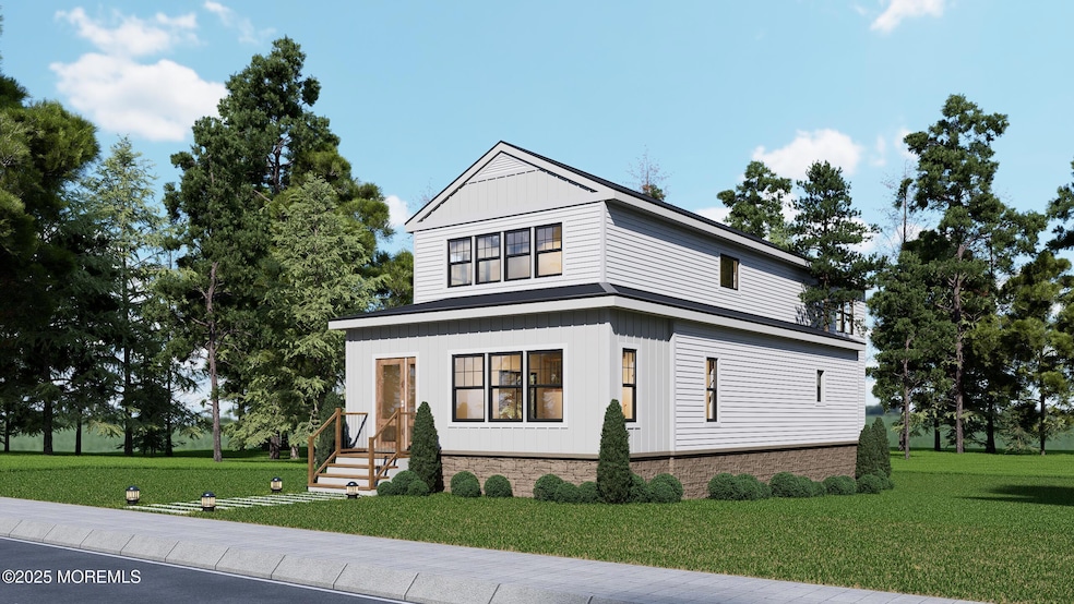
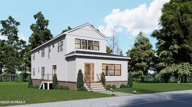
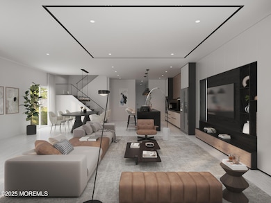
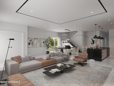
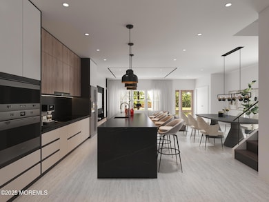
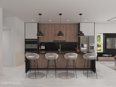
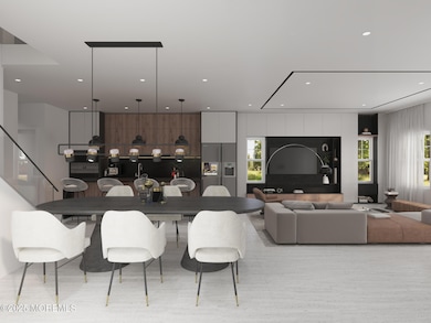
Returning to Market - Zoning Permitted & Ready to Build! Skip months of planning and permitting with this rare turnkey investment opportunity at 103 Poplar Avenue, featuring a 900 SF single-family residence on 0.208 acres with approved plans to transform into a stunning 2,402 SF modern farmhouse. Zoning permits issued September 2025, with architectural plans complete for a 5-bedroom, 3.5-bathroom two-story home featuring open-concept living, gourmet kitchen, primary suite, and contemporary finishes. The approved construction scope includes a 245 SF first-floor addition, complete 1,008 SF second-story addition, and engineered flood compliance (FEMA Zone AE), with all structural, mechanical, and design work permitted and ready for quick groundbreaking. Professional renderings available
Home Details
Home Type
- Single Family
Est. Annual Taxes
- $3,269
Home Design
- Custom Home
- Contemporary Architecture
- Farmhouse Style Home
- Foundation Flood Vent
- Asphalt Rolled Roof
Interior Spaces
- 2-Story Property
- Unfinished Basement
Bedrooms and Bathrooms
- 5 Bedrooms
Schools
- Deal Elementary And Middle School
- Asbury Park High School
Utilities
- Central Air
- Electric Water Heater
Community Details
- No Home Owners Association
Listing and Financial Details
- Assessor Parcel Number 11-00017-00005
Map
Home Values in the Area
Average Home Value in this Area
Tax History
| Year | Tax Paid | Tax Assessment Tax Assessment Total Assessment is a certain percentage of the fair market value that is determined by local assessors to be the total taxable value of land and additions on the property. | Land | Improvement |
|---|---|---|---|---|
| 2025 | $3,269 | $883,600 | $745,900 | $137,700 |
| 2024 | $3,446 | $765,500 | $642,000 | $123,500 |
| 2023 | $3,446 | $749,200 | $641,700 | $107,500 |
| 2022 | $3,407 | $578,100 | $502,600 | $75,500 |
| 2021 | $2,553 | $524,200 | $453,300 | $70,900 |
| 2020 | $2,666 | $373,400 | $218,100 | $155,300 |
| 2019 | $2,553 | $360,100 | $205,700 | $154,400 |
| 2018 | $2,424 | $349,300 | $205,700 | $143,600 |
| 2017 | $2,649 | $380,000 | $240,900 | $139,100 |
| 2016 | $2,486 | $355,600 | $225,100 | $130,500 |
| 2015 | $2,500 | $349,700 | $225,100 | $124,600 |
| 2014 | $2,248 | $314,900 | $220,600 | $94,300 |
Property History
| Date | Event | Price | List to Sale | Price per Sq Ft |
|---|---|---|---|---|
| 11/10/2025 11/10/25 | For Sale | $1,250,000 | -- | -- |
Purchase History
| Date | Type | Sale Price | Title Company |
|---|---|---|---|
| Deed | $872,449 | First American Title | |
| Deed | $872,449 | First American Title |
Mortgage History
| Date | Status | Loan Amount | Loan Type |
|---|---|---|---|
| Open | $1,201,400 | Construction | |
| Closed | $1,201,400 | Construction |
Source: MOREMLS (Monmouth Ocean Regional REALTORS®)
MLS Number: 22534065
APN: 11-00017-0000-00005
Disclaimer: Certain information contained herein is derived from information provided by parties other than Homes.com. All information provided is deemed reliable, but is not guaranteed to be accurate and should be independently verified.
![]() IDX information is provided exclusively for personal, non-commercial use, and may not be used for any purpose other than to identify prospective properties consumers may be interested in purchasing.
IDX information is provided exclusively for personal, non-commercial use, and may not be used for any purpose other than to identify prospective properties consumers may be interested in purchasing.
Information is deemed reliable but not guaranteed.
- 116 Phillips Ave
- 10 Campbell Ct
- 328 Elberon Blvd
- 0 Overbrook Ave
- 267 Roosevelt Ave
- 1 Country Club Dr
- 306 Roosevelt Ave
- 271 Jerome Ave
- 296 Garfield Ave
- 210 Larchwood Ave
- 24 Berger Ave
- 206 S Lincoln Ave
- 404 Brookside Ave
- 1039 Norwood Ave
- 160 Ocean Ave
- 460 Runyan Ave
- 1001 Norwood Ave Unit 5
- 1001 Norwood Ave Unit 6
- 408 Crosby Ave
- 221 Elmwood Rd
- 95 Poplar Ave
- 106 Poplar Ave
- 92 Poplar Ave
- 89 Poplar Ave Unit East Side
- 17 Wyckoff St
- 13 Wyckoff St
- 21 Wyckoff St
- 215 W Morgan Ave Unit 8
- 12 Wyckoff St
- 215 W Morgan Ave Unit 6
- 98 Norwood Ave Unit 4
- 24 Campbell Ct
- 10 Campbell Ct
- 10 Campbell Ct Unit A
- 117 Brighton Ave
- 246 Roosevelt Ave Unit Front House
- 229 Overbrook Ave
- 18 Joanna Ct
- 95 Skinner Dr
- 259 Roosevelt Ave
