Estimated Value: $2,872,000 - $7,254,000
3
Beds
2
Baths
8,625
Sq Ft
$564/Sq Ft
Est. Value
About This Home
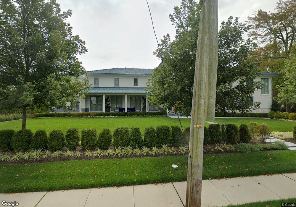
This home is located at 103 Sherman Ave, Deal, NJ 07723 and is currently estimated at $4,868,384, approximately $564 per square foot. 103 Sherman Ave is a home located in Monmouth County with nearby schools including Ocean Township High School, St. Mary of the Assumption School, and Ma'or Yeshiva High School for Boys.
Ownership History
Date
Name
Owned For
Owner Type
Purchase Details
Closed on
Nov 4, 2020
Sold by
Choueka Ilyaho
Bought by
Monmouth County
Current Estimated Value
Home Financials for this Owner
Home Financials are based on the most recent Mortgage that was taken out on this home.
Interest Rate
2.81%
Purchase Details
Closed on
Sep 28, 2018
Sold by
Serouya Abraham C and Serouya Sarah
Bought by
Choueka Ilyaho
Home Financials for this Owner
Home Financials are based on the most recent Mortgage that was taken out on this home.
Original Mortgage
$1,161,600
Interest Rate
4.45%
Mortgage Type
Adjustable Rate Mortgage/ARM
Purchase Details
Closed on
Aug 20, 2015
Sold by
Serouya Abraham C
Bought by
Serouya Abraham C
Create a Home Valuation Report for This Property
The Home Valuation Report is an in-depth analysis detailing your home's value as well as a comparison with similar homes in the area
Home Values in the Area
Average Home Value in this Area
Purchase History
| Date | Buyer | Sale Price | Title Company |
|---|---|---|---|
| Monmouth County | -- | -- | |
| Choueka Ilyaho | $1,452,000 | Berkshire Abstract & Title A | |
| Serouya Abraham C | -- | None Available |
Source: Public Records
Mortgage History
| Date | Status | Borrower | Loan Amount |
|---|---|---|---|
| Closed | Monmouth County | -- | |
| Previous Owner | Choueka Ilyaho | $1,161,600 |
Source: Public Records
Tax History Compared to Growth
Tax History
| Year | Tax Paid | Tax Assessment Tax Assessment Total Assessment is a certain percentage of the fair market value that is determined by local assessors to be the total taxable value of land and additions on the property. | Land | Improvement |
|---|---|---|---|---|
| 2025 | $75,581 | $5,556,800 | $3,065,300 | $2,491,500 |
| 2024 | $76,078 | $5,300,200 | $2,865,300 | $2,434,900 |
| 2023 | $76,078 | $4,975,700 | $2,515,300 | $2,460,400 |
| 2022 | $30,186 | $1,812,300 | $1,812,300 | $0 |
| 2021 | $30,186 | $1,536,200 | $1,276,700 | $259,500 |
| 2020 | $25,314 | $1,271,400 | $1,017,800 | $253,600 |
| 2019 | $23,856 | $1,170,000 | $917,800 | $252,200 |
| 2018 | $22,996 | $1,098,200 | $857,800 | $240,400 |
| 2017 | $20,820 | $990,000 | $742,800 | $247,200 |
| 2016 | $17,986 | $769,300 | $561,500 | $207,800 |
| 2015 | $17,638 | $763,900 | $561,500 | $202,400 |
| 2014 | $17,106 | $750,900 | $561,500 | $189,400 |
Source: Public Records
Map
Nearby Homes
- 10 Campbell Ct
- 116 Phillips Ave
- 103 Poplar Ave
- 1 Country Club Dr
- 460 Runyan Ave
- 0 Overbrook Ave
- 408 Crosby Ave
- 328 Elberon Blvd
- 404 Brookside Ave
- 267 Roosevelt Ave
- 306 Roosevelt Ave
- 504 Crosby Ave
- 160 Ocean Ave
- 296 Garfield Ave
- 210 Larchwood Ave
- 271 Jerome Ave
- 221 Elmwood Rd
- 18 Lady Bess Dr
- 24 Berger Ave
- 243 Woodcrest Rd
- 450 Holly Terrace
- 101 Sherman Ave
- 104 Sherman Ave
- 448 Holly Terrace
- 102 Sherman Ave
- 102 Parker Ave
- 100 Sherman Ave
- 106 Parker Ave
- 106 Sherman Ave
- 98 Sherman Ave
- 451 Holly Terrace
- 100 Parker Ave
- 138 Brighton Ave
- 200 Sherman Ave
- 200 Parker Ave
- 136 Brighton Ave
- 201 Sherman Ave
- 134 Brighton Ave
- 107 Grant Ave
- 105 Grant Ave