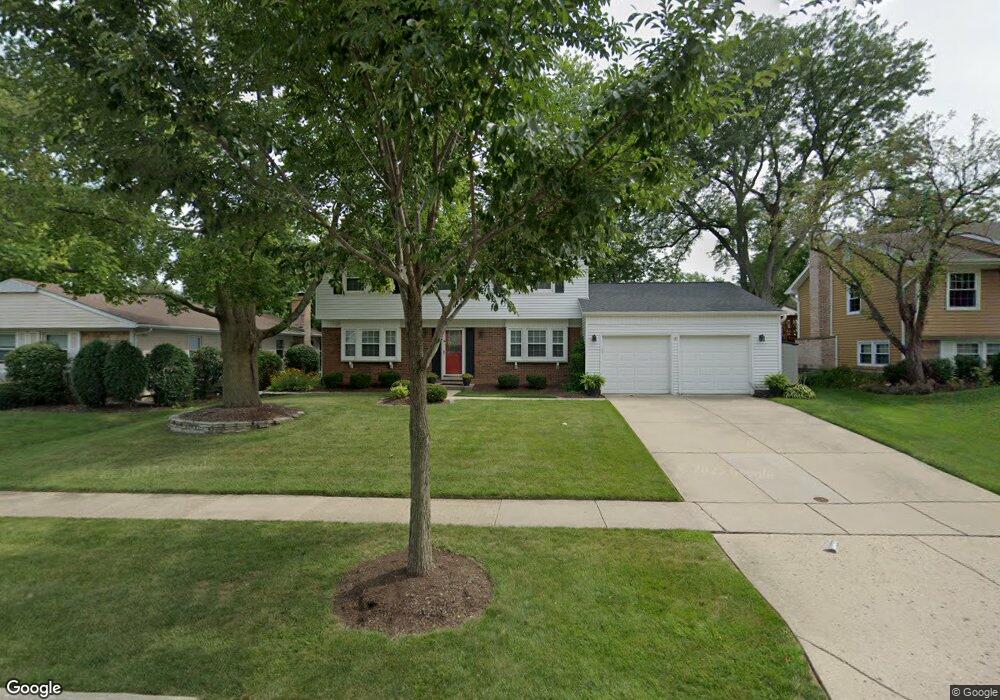
103 Stonegate Rd Buffalo Grove, IL 60089
South Buffalo Grove NeighborhoodEstimated Value: $466,000 - $493,000
4
Beds
3
Baths
2,068
Sq Ft
$232/Sq Ft
Est. Value
About This Home
This home is located at 103 Stonegate Rd, Buffalo Grove, IL 60089 and is currently estimated at $480,260, approximately $232 per square foot. 103 Stonegate Rd is a home located in Cook County with nearby schools including Henry W Longfellow Elementary School, Cooper Middle School, and Buffalo Grove High School.
Ownership History
Date
Name
Owned For
Owner Type
Purchase Details
Closed on
Jul 22, 1994
Sold by
Blackburn Charles E and Blackburn Laurel H
Bought by
Walker David M and Walker Stephanie D
Current Estimated Value
Home Financials for this Owner
Home Financials are based on the most recent Mortgage that was taken out on this home.
Original Mortgage
$154,400
Interest Rate
6.5%
Create a Home Valuation Report for This Property
The Home Valuation Report is an in-depth analysis detailing your home's value as well as a comparison with similar homes in the area
Home Values in the Area
Average Home Value in this Area
Purchase History
| Date | Buyer | Sale Price | Title Company |
|---|---|---|---|
| Walker David M | $290,000 | 1St American Title |
Source: Public Records
Mortgage History
| Date | Status | Borrower | Loan Amount |
|---|---|---|---|
| Closed | Walker David M | $154,400 |
Source: Public Records
Tax History
| Year | Tax Paid | Tax Assessment Tax Assessment Total Assessment is a certain percentage of the fair market value that is determined by local assessors to be the total taxable value of land and additions on the property. | Land | Improvement |
|---|---|---|---|---|
| 2025 | $10,781 | $43,000 | $8,820 | $34,180 |
| 2024 | $10,781 | $37,000 | $7,560 | $29,440 |
| 2023 | $10,340 | $37,000 | $7,560 | $29,440 |
| 2022 | $10,340 | $37,000 | $7,560 | $29,440 |
| 2021 | $9,545 | $30,347 | $4,830 | $25,517 |
| 2020 | $9,367 | $30,347 | $4,830 | $25,517 |
| 2019 | $9,355 | $33,645 | $4,830 | $28,815 |
| 2018 | $9,188 | $30,114 | $4,200 | $25,914 |
| 2017 | $9,039 | $30,114 | $4,200 | $25,914 |
| 2016 | $8,674 | $30,114 | $4,200 | $25,914 |
| 2015 | $8,583 | $27,887 | $3,570 | $24,317 |
| 2014 | $8,459 | $27,887 | $3,570 | $24,317 |
| 2013 | $7,801 | $27,887 | $3,570 | $24,317 |
Source: Public Records
Map
Nearby Homes
- 915 Plum Grove Cir
- 267 Timber Hill Rd
- 170 Cherrywood Rd
- 610 Maple Dr
- 252 Appletree Ct
- 225 Thornapple Ct Unit 225
- 462 Longwood Dr
- 858 Old Checker Rd Unit C4
- 4210 N Walnut Ave
- 571 Estate Dr
- 1096 Beechwood Rd
- 632 Weidner Rd
- 440 Burnt Ember Ln
- 612 White Pine Rd
- 876 Stradford Cir Unit A1
- 170 Manchester Dr Unit 306
- 232 Manor Dr Unit 12C
- 800 Weidner Rd Unit 208
- 760 Weidner Rd Unit 107
- 820 Weidner Rd Unit 4013
- 105 Stonegate Rd
- 101 Stonegate Rd
- 894 Country Ln
- 904 Country Ln
- 882 Country Ln
- 107 Stonegate Rd
- 99 Stonegate Rd
- 1 Stonegate Ct
- 102 Stonegate Rd
- 914 Country Ln
- 100 Stonegate Rd
- 109 Stonegate Rd
- 856 Country Ln
- 924 Country Ln
- 886 Plum Grove Cir
- 2 Stonegate Ct
- 115 Stonegate Rd
- 68 Timber Hill Rd
- 883 Plum Grove Cir
- 62 Timber Hill Rd Unit 3