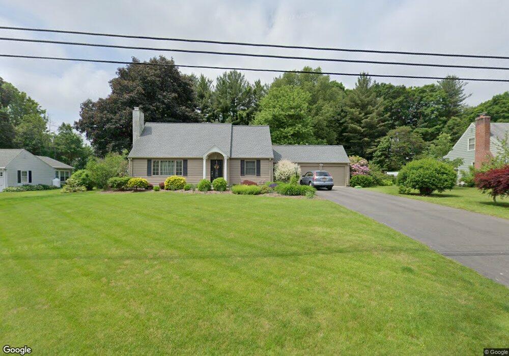
103 Woodpond Rd West Hartford, CT 06107
Estimated Value: $578,000 - $705,000
3
Beds
2
Baths
2,388
Sq Ft
$272/Sq Ft
Est. Value
About This Home
This home is located at 103 Woodpond Rd, West Hartford, CT 06107 and is currently estimated at $648,875, approximately $271 per square foot. 103 Woodpond Rd is a home located in Hartford County with nearby schools including East Farms School, West Woods Upper Elementary School, and Irving A. Robbins Middle School.
Ownership History
Date
Name
Owned For
Owner Type
Purchase Details
Closed on
Dec 1, 1993
Sold by
Fricke Ex Norman G
Bought by
Skelly Martin and Mambrino Donna M
Current Estimated Value
Home Financials for this Owner
Home Financials are based on the most recent Mortgage that was taken out on this home.
Original Mortgage
$156,700
Interest Rate
6.69%
Mortgage Type
Unknown
Create a Home Valuation Report for This Property
The Home Valuation Report is an in-depth analysis detailing your home's value as well as a comparison with similar homes in the area
Home Values in the Area
Average Home Value in this Area
Purchase History
| Date | Buyer | Sale Price | Title Company |
|---|---|---|---|
| Skelly Martin | $165,000 | -- |
Source: Public Records
Mortgage History
| Date | Status | Borrower | Loan Amount |
|---|---|---|---|
| Closed | Skelly Martin | $206,000 | |
| Closed | Skelly Martin | $156,700 |
Source: Public Records
Tax History Compared to Growth
Tax History
| Year | Tax Paid | Tax Assessment Tax Assessment Total Assessment is a certain percentage of the fair market value that is determined by local assessors to be the total taxable value of land and additions on the property. | Land | Improvement |
|---|---|---|---|---|
| 2025 | $7,877 | $295,890 | $106,470 | $189,420 |
| 2024 | $7,530 | $295,890 | $106,470 | $189,420 |
| 2023 | $7,163 | $295,890 | $106,470 | $189,420 |
| 2022 | $6,329 | $215,720 | $88,700 | $127,020 |
| 2021 | $6,215 | $215,720 | $88,700 | $127,020 |
| 2020 | $6,034 | $215,720 | $88,700 | $127,020 |
| 2019 | $6,034 | $215,720 | $88,700 | $127,020 |
| 2018 | $5,863 | $215,720 | $88,700 | $127,020 |
| 2017 | $6,471 | $242,550 | $124,770 | $117,780 |
| 2016 | $6,253 | $242,550 | $124,770 | $117,780 |
| 2015 | $6,066 | $242,550 | $124,770 | $117,780 |
| 2014 | $5,929 | $242,590 | $124,810 | $117,780 |
Source: Public Records
Map
Nearby Homes
- 294 Tunxis Rd
- 7 Brookmoor Rd
- 61 Waterside Ln
- 38 Mildred Rd
- 25 Birch Hill Dr
- 21 Echo Ln
- 32 Miles Standish Dr
- 236 Ridgewood Rd
- 26 Garland Rd
- 34 Sandhurst Dr
- 42 Fairwood Farms Dr
- 00 Old Farm Dr
- 29 Fairwood Farms Dr
- 117 Tunxis Rd
- 293 Elmfield St
- 88 Spring Ln
- 73 Emily Way
- 25 Fowler Dr
- 126 Westminster Dr
- 91 Shadow Ln Unit A2
- 99 Woodpond Rd
- 107 Woodpond Rd
- 108 Woodpond Rd
- 104 Woodpond Rd
- 100 Woodpond Rd
- 95 Woodpond Rd
- 111 Woodpond Rd
- 116 Woodpond Rd
- 96 Woodpond Rd
- 112 Woodpond Rd
- 91 Woodpond Rd
- 24 Ridgeview Dr
- 22 Ridgeview Dr
- 120 Woodpond Rd
- 117 Woodpond Rd
- 92 Woodpond Rd
- 26 Ridgeview Dr
- 20 Ridgeview Dr
- 87 Woodpond Rd
- 124 Woodpond Rd