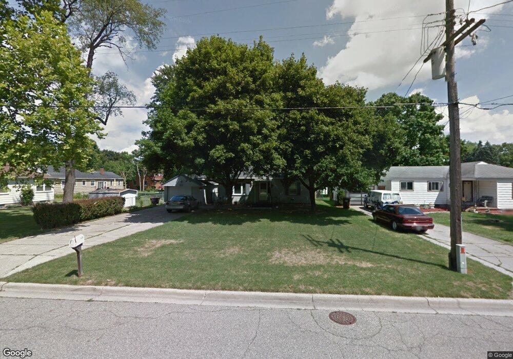
1030 Bretton Rd Lansing, MI 48917
Estimated Value: $181,000 - $195,000
3
Beds
2
Baths
1,128
Sq Ft
$167/Sq Ft
Est. Value
About This Home
This home is located at 1030 Bretton Rd, Lansing, MI 48917 and is currently estimated at $188,754, approximately $167 per square foot. 1030 Bretton Rd is a home located in Eaton County with nearby schools including Waverly Senior High School, Windemere Park Charter Academy, and St. Gerard Elementary School.
Ownership History
Date
Name
Owned For
Owner Type
Purchase Details
Closed on
Oct 13, 2017
Sold by
Pavick Catherine A
Bought by
Daniels Lisa E
Current Estimated Value
Home Financials for this Owner
Home Financials are based on the most recent Mortgage that was taken out on this home.
Original Mortgage
$106,240
Outstanding Balance
$90,017
Interest Rate
4.37%
Mortgage Type
FHA
Estimated Equity
$98,737
Purchase Details
Closed on
Feb 13, 2003
Sold by
Rademacher Urban J and Rademacher Theresa A
Bought by
Pavick Catherine A
Home Financials for this Owner
Home Financials are based on the most recent Mortgage that was taken out on this home.
Original Mortgage
$101,445
Interest Rate
6%
Create a Home Valuation Report for This Property
The Home Valuation Report is an in-depth analysis detailing your home's value as well as a comparison with similar homes in the area
Home Values in the Area
Average Home Value in this Area
Purchase History
| Date | Buyer | Sale Price | Title Company |
|---|---|---|---|
| Daniels Lisa E | $108,200 | Title Source Inc | |
| Pavick Catherine A | $133,100 | -- |
Source: Public Records
Mortgage History
| Date | Status | Borrower | Loan Amount |
|---|---|---|---|
| Open | Daniels Lisa E | $106,240 | |
| Previous Owner | Pavick Catherine A | $101,445 | |
| Closed | Pavick Catherine A | $25,000 |
Source: Public Records
Tax History
| Year | Tax Paid | Tax Assessment Tax Assessment Total Assessment is a certain percentage of the fair market value that is determined by local assessors to be the total taxable value of land and additions on the property. | Land | Improvement |
|---|---|---|---|---|
| 2025 | $2,811 | $81,100 | $0 | $0 |
| 2024 | $1,641 | $76,300 | $0 | $0 |
| 2023 | $1,577 | $68,800 | $0 | $0 |
| 2022 | $2,483 | $64,900 | $0 | $0 |
| 2021 | $2,401 | $59,000 | $0 | $0 |
| 2020 | $2,473 | $55,800 | $0 | $0 |
| 2019 | $2,418 | $53,586 | $0 | $0 |
| 2018 | $2,411 | $52,300 | $0 | $0 |
| 2017 | $2,650 | $52,200 | $0 | $0 |
| 2016 | -- | $51,200 | $0 | $0 |
| 2015 | -- | $50,900 | $0 | $0 |
| 2014 | -- | $49,500 | $0 | $0 |
| 2013 | -- | $49,900 | $0 | $0 |
Source: Public Records
Map
Nearby Homes
- 1031 Mall Dr E
- 0 San Gabriel
- 415 Winifred Ave
- 401 Richard Ave
- 410 Renker Rd
- 321 Renker Rd
- 215 Winifred Ave Unit A & B
- 0000 N Dibble Ave
- 1930 Briarwood Dr
- 3723 Springbrook Ln
- 205 Renker Rd
- 1222 Ravenswood Dr
- 5137 Dorene Dr
- 2216 River Ct
- 5201 Greenbriar Rd
- 1510 Sand Point Dr
- 2517 W Michigan Ave
- 1805 Boynton Dr
- 3707 W Michigan Ave
- 1115 Boynton Dr
- 1024 Bretton Rd
- 4525 Addison Rd
- 1040 Bretton Rd
- 1020 Bretton Rd
- 4515 Addison Rd
- 1041 Robins Rd
- 1035 Robins Rd
- 1018 Bretton Rd
- 4611 Addison Rd
- 1027 Robins Rd
- 1023 Bretton Rd
- 1045 Robins Rd
- 4613 Addison Rd
- 4526 Addison Rd
- 1021 Bretton Rd
- 4530 Addison Rd
- 4516 Addison Rd
- 4538 Elizabeth Rd
- 1015 Bretton Rd
- 1038 Robins Rd
Your Personal Tour Guide
Ask me questions while you tour the home.