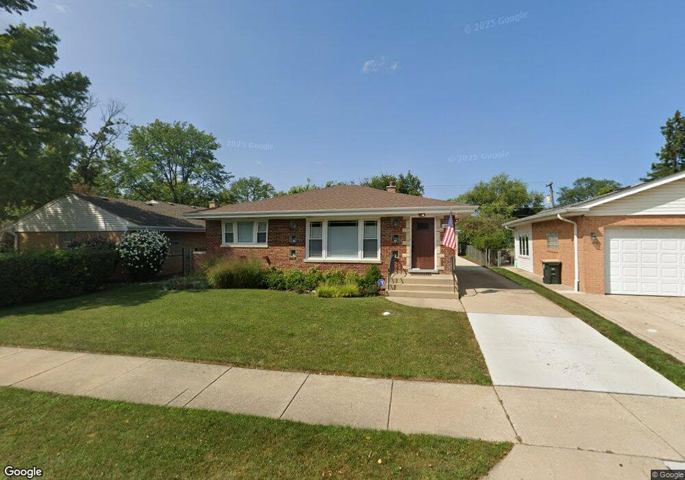
1030 Devon Ave Park Ridge, IL 60068
Estimated Value: $352,000 - $604,000
3
Beds
2
Baths
1,141
Sq Ft
$412/Sq Ft
Est. Value
About This Home
This home is located at 1030 Devon Ave, Park Ridge, IL 60068 and is currently estimated at $470,223, approximately $412 per square foot. 1030 Devon Ave is a home located in Cook County with nearby schools including Theodore Roosevelt Elementary School, Lincoln Middle School, and Maine South High School.
Ownership History
Date
Name
Owned For
Owner Type
Purchase Details
Closed on
Aug 5, 2022
Sold by
Maheras Tom
Bought by
Thomas C Maheras Revocable Trust
Current Estimated Value
Purchase Details
Closed on
Jun 30, 2022
Sold by
Maxawa Ii Llc
Bought by
Maheras Tom
Purchase Details
Closed on
Oct 30, 2020
Sold by
Lymperopulos Erika and Estate Of Stephanie Podbevsek
Bought by
Maxaipa Ii Llc
Create a Home Valuation Report for This Property
The Home Valuation Report is an in-depth analysis detailing your home's value as well as a comparison with similar homes in the area
Home Values in the Area
Average Home Value in this Area
Purchase History
| Date | Buyer | Sale Price | Title Company |
|---|---|---|---|
| Thomas C Maheras Revocable Trust | -- | None Listed On Document | |
| Maheras Tom | -- | None Listed On Document | |
| Maxaipa Ii Llc | $250,000 | Attorneys Ttl Guaranty Fund |
Source: Public Records
Tax History Compared to Growth
Tax History
| Year | Tax Paid | Tax Assessment Tax Assessment Total Assessment is a certain percentage of the fair market value that is determined by local assessors to be the total taxable value of land and additions on the property. | Land | Improvement |
|---|---|---|---|---|
| 2024 | $3,960 | $16,249 | $5,610 | $10,639 |
| 2023 | $3,781 | $16,249 | $5,610 | $10,639 |
| 2022 | $3,781 | $16,249 | $5,610 | $10,639 |
| 2021 | $3,802 | $12,500 | $3,465 | $9,035 |
| 2020 | $3,651 | $12,500 | $3,465 | $9,035 |
| 2019 | $3,767 | $14,452 | $3,465 | $10,987 |
| 2018 | $4,471 | $15,623 | $2,970 | $12,653 |
| 2017 | $4,452 | $15,623 | $2,970 | $12,653 |
| 2016 | $1,820 | $15,623 | $2,970 | $12,653 |
| 2015 | $2,149 | $15,269 | $2,475 | $12,794 |
| 2014 | $2,063 | $15,269 | $2,475 | $12,794 |
| 2013 | $2,000 | $15,269 | $2,475 | $12,794 |
Source: Public Records
Map
Nearby Homes
- 1015 Arthur St
- 1014 S Chester Ave
- 1016 Arthur St
- 1116 S Cumberland Ave
- 901 S Cumberland Ave
- 919 S Chester Ave
- 820 W Talcott Rd
- 819 Albion Ave
- 425 W Talcott Rd
- 1219 S Western Ave
- 1425 Brophy Ave
- 1220 Courtland Ave
- 929 S Aldine Ave
- 1610 S Greenwood Ave
- 623 S Prospect Ave
- 1634 S Cumberland Ave
- 428 S Clifton Ave
- 1715 S Greenwood Ave
- 1705 S Prospect Ave
- 1805 Brophy Ave
- 1030 Devon Ave
- 1131 S Chester Ave
- 1131 S Chester Ave
- 1026 Devon Ave
- 1026 Devon Ave
- 1022 Devon Ave
- 1022 Devon Ave
- 1117 S Chester Ave
- 1130 S Chester Ave
- 1130 S Chester Ave
- 1021 Saint James Place
- 1111 S Chester Ave
- 1020 Devon Ave
- 1020 Devon Ave
- 1015 Saint James Place
- 1012 Devon Ave
- 1012 Devon Ave
- 1012 Devon Ave
- 1104 Devon Ave
- 1104 Devon Ave