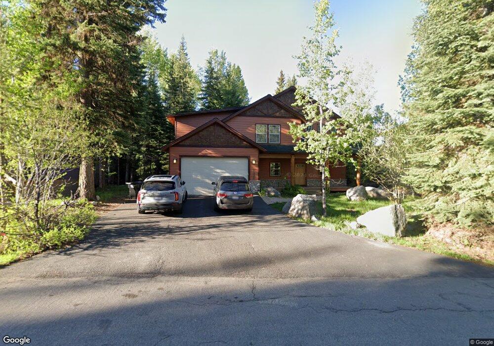
1030 Fireweed Dr McCall, ID 83638
Estimated Value: $1,020,000 - $1,463,000
4
Beds
3
Baths
2,765
Sq Ft
$431/Sq Ft
Est. Value
About This Home
This home is located at 1030 Fireweed Dr, McCall, ID 83638 and is currently estimated at $1,191,626, approximately $430 per square foot. 1030 Fireweed Dr is a home located in Valley County with nearby schools including McCall-Donnelly High School, Mountain Life Education, and The North Fork School.
Ownership History
Date
Name
Owned For
Owner Type
Purchase Details
Closed on
Mar 2, 2012
Sold by
Mcclain Daniel Wayne and Mcclain Vallerie C
Bought by
Mcclain Gerald D and Mcclain Barbara A
Current Estimated Value
Purchase Details
Closed on
Jan 27, 2011
Sold by
Mcclain Daniel Wayne
Bought by
Mcclain Daniel Wayne and Mcclain Vallerie C
Purchase Details
Closed on
Jun 4, 2010
Sold by
Mcclain Vallerie Colleen and Mcclain Daniel Wayne
Bought by
Mcclain Daniel Wayne
Purchase Details
Closed on
Nov 18, 2009
Sold by
Daniels Lance A and Daniels Kimberly K
Bought by
Wells Fargo Bank Na
Create a Home Valuation Report for This Property
The Home Valuation Report is an in-depth analysis detailing your home's value as well as a comparison with similar homes in the area
Home Values in the Area
Average Home Value in this Area
Purchase History
| Date | Buyer | Sale Price | Title Company |
|---|---|---|---|
| Mcclain Gerald D | -- | First American Title | |
| Mcclain Daniel Wayne | -- | -- | |
| Mcclain Daniel Wayne | -- | -- | |
| Mcclain Daniel Wayne | -- | -- | |
| Wells Fargo Bank Na | $91,195 | -- |
Source: Public Records
Tax History
| Year | Tax Paid | Tax Assessment Tax Assessment Total Assessment is a certain percentage of the fair market value that is determined by local assessors to be the total taxable value of land and additions on the property. | Land | Improvement |
|---|---|---|---|---|
| 2025 | $5,452 | $1,227,407 | $238,534 | $988,873 |
| 2023 | $5,452 | $1,143,560 | $218,447 | $925,113 |
| 2022 | $4,707 | $928,762 | $238,534 | $690,228 |
| 2021 | $5,041 | $657,447 | $74,569 | $582,878 |
| 2020 | $4,842 | $554,404 | $76,983 | $477,421 |
| 2019 | $4,578 | $479,849 | $69,984 | $409,865 |
| 2018 | $4,945 | $473,269 | $54,596 | $418,673 |
| 2017 | $4,584 | $410,567 | $54,056 | $356,511 |
| 2016 | $4,727 | $416,006 | $62,008 | $353,998 |
| 2015 | $2,463 | $417,257 | $0 | $0 |
| 2013 | -- | $434,561 | $0 | $0 |
Source: Public Records
Map
Nearby Homes
- 1034 Fireweed Dr
- 1008 Penstemen Place
- 1349 Hearthstone Ct Unit 9-G
- 1329 Hearthstone Ct Unit 5A
- 1130 Bell Flower Place
- 1361 Hearthstone Ct Unit 12H
- 1389 Hearthstone Ct Unit 17-E
- 1391 Hearthstone Ct Unit 18-D
- 1160 Bell Flower Place
- 1008 Violet Way
- 943 Cottage Ct
- 1175 Majestic View Dr Unit 5
- 1425 Majestic View Dr Unit 82
- 1435 Majestic View Dr
- 1615 Majestic View Dr Unit 49
- 1175 Majestic View Dr
- 1615 Majestic View Dr
- 1425 Majestic View Dr
- 1435 Majestic View Dr Unit 81
- 1345 Divot Ln
- 1032 Fireweed Dr
- 1032 Fireweed Dr Unit Drive
- 1028 Fireweed
- Lot 19 Fireweed Dr Unit 19
- Lot 24 Fireweed Dr Unit 24
- 1010 Fireweed Dr Unit 3
- 1017 Fireweed Dr Unit 9
- 1011 Fireweed Dr Unit 6
- 1038 Fireweed Dr Unit 17
- 1021 Fireweed Dr Unit 11
- 1010 Fireweed Dr
- 1021 Fireweed Dr
- 1025 Bitterroot Dr
- 1026 Fireweed Dr
- 1025 Fireweed Dr
- 1027 Fireweed
- 1021 Bitterroot Dr
- L109 Bitterroot Dr
- 1024 Fireweed Dr Unit 10
- 1024 Fireweed Dr
Your Personal Tour Guide
Ask me questions while you tour the home.