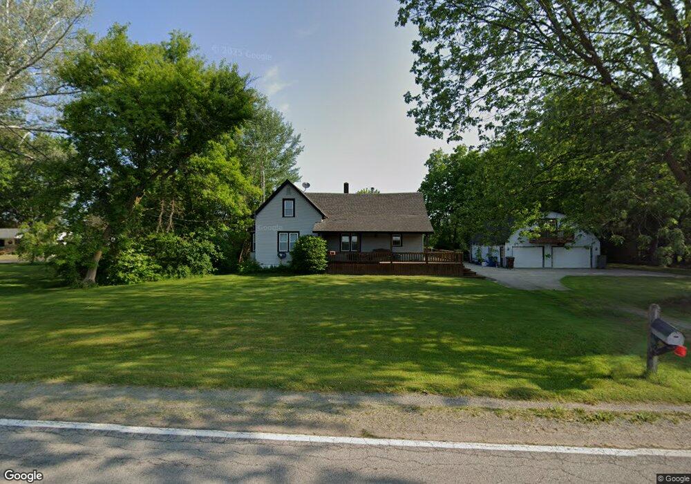
10300 Frances Rd Flushing, MI 48433
Estimated Value: $231,000 - $306,000
3
Beds
1
Bath
1,252
Sq Ft
$216/Sq Ft
Est. Value
About This Home
This home is located at 10300 Frances Rd, Flushing, MI 48433 and is currently estimated at $270,249, approximately $215 per square foot. 10300 Frances Rd is a home located in Genesee County with nearby schools including Carter Elementary School, Kuehn-Haven Middle School, and Hill-McCloy High School.
Ownership History
Date
Name
Owned For
Owner Type
Purchase Details
Closed on
Mar 23, 2000
Sold by
Jensen Bruce A and Jensen Angela D
Bought by
Carley David J
Current Estimated Value
Home Financials for this Owner
Home Financials are based on the most recent Mortgage that was taken out on this home.
Original Mortgage
$114,000
Outstanding Balance
$38,914
Interest Rate
8.39%
Mortgage Type
Purchase Money Mortgage
Estimated Equity
$231,335
Create a Home Valuation Report for This Property
The Home Valuation Report is an in-depth analysis detailing your home's value as well as a comparison with similar homes in the area
Home Values in the Area
Average Home Value in this Area
Purchase History
| Date | Buyer | Sale Price | Title Company |
|---|---|---|---|
| Carley David J | $142,500 | First American Title Ins Co |
Source: Public Records
Mortgage History
| Date | Status | Borrower | Loan Amount |
|---|---|---|---|
| Open | Carley David J | $114,000 |
Source: Public Records
Tax History
| Year | Tax Paid | Tax Assessment Tax Assessment Total Assessment is a certain percentage of the fair market value that is determined by local assessors to be the total taxable value of land and additions on the property. | Land | Improvement |
|---|---|---|---|---|
| 2025 | $2,358 | $113,700 | $0 | $0 |
| 2024 | $645 | $104,100 | $0 | $0 |
| 2023 | $616 | $94,500 | $0 | $0 |
| 2022 | $2,109 | $90,900 | $0 | $0 |
| 2021 | $2,054 | $73,600 | $0 | $0 |
| 2020 | $563 | $70,900 | $0 | $0 |
| 2019 | $554 | $64,800 | $0 | $0 |
| 2018 | $1,910 | $61,200 | $0 | $0 |
| 2017 | $1,784 | $61,200 | $0 | $0 |
| 2016 | $1,768 | $57,100 | $0 | $0 |
| 2015 | $1,595 | $51,800 | $0 | $0 |
| 2014 | $511 | $49,300 | $0 | $0 |
| 2012 | -- | $42,700 | $42,700 | $0 |
Source: Public Records
Map
Nearby Homes
- 10195 Dodge Rd
- 8548 Tim Tam Trail
- 8522 Tim Tam Trail
- 8073 Nichols Rd
- 10045 Nichols Rd
- 10149 Seymour Rd
- 9222 N Mckinley Rd
- 8506 Duffield Rd
- 271 Lovell Ct
- 255 Grissom Ct
- 11186 W Stanley Rd
- 12300 Dodge Rd
- 9197 Sheridan Rd
- 296 S Saginaw St
- 6355 N Mckinley Rd
- 13453 Seymour Rd
- 7452 Dodge Rd
- 189 S Genesee St
- 000 E Oak St
- 258 E State St
- 10398 Frances Rd
- 10384 Frances Rd
- 10276 Frances Rd
- 10276 Frances Rd
- 10320 Frances Rd
- 10259 Frances Rd
- 10243 Frances Rd
- 10260 Frances Rd
- 10235 Frances Rd
- 10242 Frances Rd
- 10223 Frances Rd
- 10232 W Frances Rd
- 10232 Frances Rd
- 10215 Frances Rd
- 10216 Frances Rd
- 10207 Frances Rd
- 10210 W Frances Rd
- 10210 Frances Rd
- 10189 Frances Rd
- 10340 Frances Rd
Your Personal Tour Guide
Ask me questions while you tour the home.