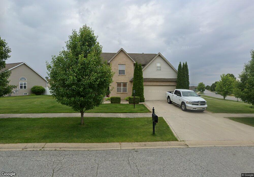
10302 Snead St Crown Point, IN 46307
Estimated Value: $404,739 - $470,000
3
Beds
3
Baths
2,798
Sq Ft
$157/Sq Ft
Est. Value
About This Home
This home is located at 10302 Snead St, Crown Point, IN 46307 and is currently estimated at $438,685, approximately $156 per square foot. 10302 Snead St is a home located in Lake County with nearby schools including Winfield Elementary School, Jerry Ross Elementary School, and Colonel John Wheeler Middle School.
Ownership History
Date
Name
Owned For
Owner Type
Purchase Details
Closed on
Jul 2, 2009
Sold by
New Nest Construction
Bought by
Meckaroski Nenad
Current Estimated Value
Home Financials for this Owner
Home Financials are based on the most recent Mortgage that was taken out on this home.
Original Mortgage
$230,718
Outstanding Balance
$150,658
Interest Rate
5.32%
Mortgage Type
FHA
Estimated Equity
$288,027
Purchase Details
Closed on
Dec 31, 2008
Sold by
Dbl Residential Lp
Bought by
New Nest Construction
Create a Home Valuation Report for This Property
The Home Valuation Report is an in-depth analysis detailing your home's value as well as a comparison with similar homes in the area
Home Values in the Area
Average Home Value in this Area
Purchase History
| Date | Buyer | Sale Price | Title Company |
|---|---|---|---|
| Meckaroski Nenad | -- | Ticor Cp | |
| New Nest Construction | -- | Meridian Title Corp |
Source: Public Records
Mortgage History
| Date | Status | Borrower | Loan Amount |
|---|---|---|---|
| Open | Meckaroski Nenad | $230,718 |
Source: Public Records
Tax History Compared to Growth
Tax History
| Year | Tax Paid | Tax Assessment Tax Assessment Total Assessment is a certain percentage of the fair market value that is determined by local assessors to be the total taxable value of land and additions on the property. | Land | Improvement |
|---|---|---|---|---|
| 2024 | $10,111 | $369,900 | $70,100 | $299,800 |
| 2023 | $3,942 | $374,500 | $70,100 | $304,400 |
| 2022 | $3,942 | $352,800 | $70,100 | $282,700 |
| 2021 | $3,665 | $328,400 | $58,500 | $269,900 |
| 2020 | $3,270 | $293,700 | $44,900 | $248,800 |
| 2019 | $3,242 | $288,300 | $44,900 | $243,400 |
| 2018 | $3,321 | $279,600 | $44,900 | $234,700 |
| 2017 | $3,296 | $278,500 | $44,900 | $233,600 |
| 2016 | $3,203 | $267,700 | $44,900 | $222,800 |
| 2014 | $2,945 | $260,600 | $44,900 | $215,700 |
| 2013 | $2,841 | $249,400 | $44,900 | $204,500 |
Source: Public Records
Map
Nearby Homes
- 10360 Doubletree Dr S
- 10380 Doubletree Dr S
- 10330 Doubletree Dr S
- 10400 Doubletree Dr S
- 8130 Lakeview Ct
- 10450 Doubletree Dr S
- 10460 Doubletree Dr S
- 8160 Lakeview Ct
- 10470 Doubletree Dr S
- The Georgetown Plan at Doubletree Lake Estates
- The Lilly Plan at Doubletree Lake Estates
- The Isabella Plan at Doubletree Lake Estates
- The Marian Plan at Doubletree Lake Estates
- The Hamilton Plan at Doubletree Lake Estates
- The Julianne Plan at Doubletree Lake Estates
- The Aviana Plan at Doubletree Lake Estates
- The Jean Plan at Doubletree Lake Estates
- The Stanford Plan at Doubletree Lake Estates
- The Aster Plan at Doubletree Lake Estates
- The Franklin Plan at Doubletree Lake Estates