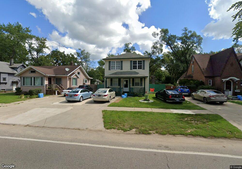
1031 Colfax Ave Benton Harbor, MI 49022
Estimated Value: $88,000 - $120,000
3
Beds
2
Baths
1,114
Sq Ft
$96/Sq Ft
Est. Value
About This Home
This home is located at 1031 Colfax Ave, Benton Harbor, MI 49022 and is currently estimated at $106,608, approximately $95 per square foot. 1031 Colfax Ave is a home located in Berrien County with nearby schools including Fair Plain Middle School, Benton Harbor High School, and Benton Harbor Charter School Academy.
Ownership History
Date
Name
Owned For
Owner Type
Purchase Details
Closed on
Jan 26, 2018
Sold by
Chritian Nalter
Bought by
Drake David
Current Estimated Value
Purchase Details
Closed on
Dec 14, 2017
Sold by
Chemical Bank
Bought by
Christian Nalter F
Purchase Details
Closed on
Oct 6, 2016
Sold by
Montgomery Virineco
Bought by
Chemical Bank
Purchase Details
Closed on
Jul 24, 2001
Purchase Details
Closed on
Jan 2, 1997
Purchase Details
Closed on
May 3, 1994
Purchase Details
Closed on
Feb 21, 1980
Purchase Details
Closed on
Nov 17, 1977
Create a Home Valuation Report for This Property
The Home Valuation Report is an in-depth analysis detailing your home's value as well as a comparison with similar homes in the area
Home Values in the Area
Average Home Value in this Area
Purchase History
| Date | Buyer | Sale Price | Title Company |
|---|---|---|---|
| Drake David | -- | None Available | |
| Christian Nalter F | $23,000 | None Available | |
| Chemical Bank | $44,013 | Attorney | |
| -- | $63,500 | -- | |
| -- | -- | -- | |
| -- | -- | -- | |
| -- | $12,900 | -- | |
| -- | $4,200 | -- |
Source: Public Records
Tax History Compared to Growth
Tax History
| Year | Tax Paid | Tax Assessment Tax Assessment Total Assessment is a certain percentage of the fair market value that is determined by local assessors to be the total taxable value of land and additions on the property. | Land | Improvement |
|---|---|---|---|---|
| 2025 | $729 | $44,700 | $0 | $0 |
| 2024 | $690 | $40,100 | $0 | $0 |
| 2023 | $507 | $21,000 | $0 | $0 |
| 2022 | $627 | $16,400 | $0 | $0 |
| 2021 | $641 | $16,200 | $700 | $15,500 |
| 2020 | $634 | $16,400 | $0 | $0 |
| 2019 | $949 | $15,100 | $0 | $0 |
| 2018 | $648 | $13,600 | $0 | $0 |
| 2017 | $1,353 | $30,800 | $0 | $0 |
| 2016 | $1,326 | $31,100 | $0 | $0 |
| 2015 | $1,323 | $29,900 | $0 | $0 |
| 2014 | $1,407 | $36,200 | $0 | $0 |
Source: Public Records
Map
Nearby Homes
- 979 Lavette Ave
- 941 Colfax Ave
- 202 Searles Ave
- 171 E Empire Ave
- 1235 Colfax Ave
- 972 Pearl St
- 304 W May St
- 131 Clay St
- 1097 Pearl St
- 361 E May St
- 349 E Empire Ave
- 180 Emery Ave
- 1045 Broadway
- 1267 Broadway
- 833 Pearl St
- 694 Colfax Ave
- 161 Kline Ave
- 1332 Columbus Ave
- 1000 Riverview Dr Unit 11
- 614 Pavone St
- 1025 Colfax Ave
- 1041 Colfax Ave
- 1019 Colfax Ave
- 1049 Colfax Ave
- 1011 Colfax Ave
- 1057 Colfax Ave
- 1030 Colfax Ave
- 1022 Colfax Ave
- 1010 Colfax Ave
- 1003 Colfax Ave
- 1067 Colfax Ave
- 1030 Lavette Ave
- 1026 Lavette Ave
- 1048 Lavette Ave
- 1040 Lavette Ave
- 1050 Colfax Ave
- 114 Parker Ave
- 1016 Lavette Ave
- 1050 Lavette Ave
- 1010 Lavette Ave