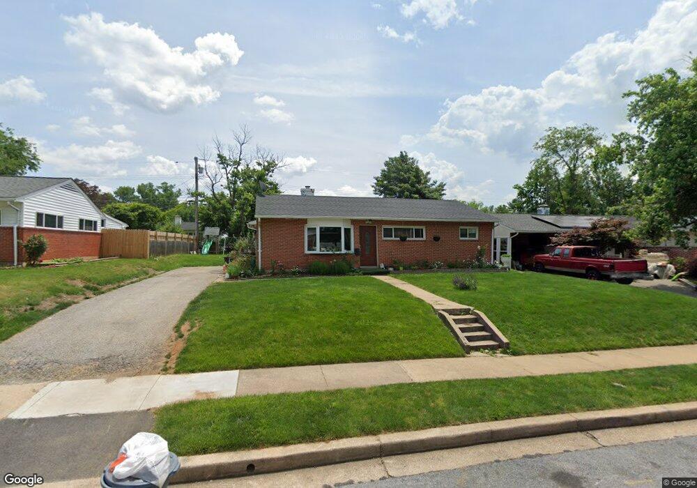
1031 Marksworth Rd Catonsville, MD 21228
Estimated Value: $296,218 - $340,000
--
Bed
1
Bath
1,121
Sq Ft
$288/Sq Ft
Est. Value
About This Home
This home is located at 1031 Marksworth Rd, Catonsville, MD 21228 and is currently estimated at $323,305, approximately $288 per square foot. 1031 Marksworth Rd is a home located in Baltimore County with nearby schools including Johnnycake Elementary School, Southwest Academy, and Woodlawn High School.
Ownership History
Date
Name
Owned For
Owner Type
Purchase Details
Closed on
Aug 6, 2018
Sold by
Sawyer Anthonia L
Bought by
Rivera Jose Ismael Diaz and Diaz Marisol Cerritos
Current Estimated Value
Home Financials for this Owner
Home Financials are based on the most recent Mortgage that was taken out on this home.
Original Mortgage
$161,500
Outstanding Balance
$140,562
Interest Rate
4.6%
Mortgage Type
New Conventional
Estimated Equity
$182,743
Purchase Details
Closed on
Aug 4, 1997
Sold by
Randecker Almedia J
Bought by
Sawyer Anthonia L
Create a Home Valuation Report for This Property
The Home Valuation Report is an in-depth analysis detailing your home's value as well as a comparison with similar homes in the area
Home Values in the Area
Average Home Value in this Area
Purchase History
| Date | Buyer | Sale Price | Title Company |
|---|---|---|---|
| Rivera Jose Ismael Diaz | $190,000 | Universal Title | |
| Sawyer Anthonia L | $78,000 | -- |
Source: Public Records
Mortgage History
| Date | Status | Borrower | Loan Amount |
|---|---|---|---|
| Open | Rivera Jose Ismael Diaz | $161,500 |
Source: Public Records
Tax History Compared to Growth
Tax History
| Year | Tax Paid | Tax Assessment Tax Assessment Total Assessment is a certain percentage of the fair market value that is determined by local assessors to be the total taxable value of land and additions on the property. | Land | Improvement |
|---|---|---|---|---|
| 2025 | $3,767 | $220,800 | -- | -- |
| 2024 | $3,767 | $205,000 | $77,900 | $127,100 |
| 2023 | $1,719 | $198,967 | $0 | $0 |
| 2022 | $3,306 | $192,933 | $0 | $0 |
| 2021 | $2,925 | $186,900 | $77,900 | $109,000 |
| 2020 | $3,288 | $177,433 | $0 | $0 |
| 2019 | $2,036 | $167,967 | $0 | $0 |
| 2018 | $2,818 | $158,500 | $64,400 | $94,100 |
| 2017 | $2,535 | $150,300 | $0 | $0 |
| 2016 | $1,721 | $142,100 | $0 | $0 |
| 2015 | $1,721 | $133,900 | $0 | $0 |
| 2014 | $1,721 | $133,900 | $0 | $0 |
Source: Public Records
Map
Nearby Homes
- 6001 Johnnycake Rd
- 6011 Johnnycake Rd
- 1109 Marksworth Rd
- 1113 Kent Ave
- 1124 Brigadoon Trail
- 1007 Kent Ave
- 1007 Marksworth Rd
- 1124 Dorchester Ave
- 5911 Carroll St
- 5932 Saint Marys St
- 1068 Craftswood Rd
- 930 Sedgley Rd
- 1206 Ingleside Ave
- 1009 Rowe Ln
- 5902 Prince George St
- 920 Vanderwood Rd
- 6028 Moorehead Rd
- 908 Vanderwood Rd
- 1405 Ingleside Ave
- 1427 Barrett Rd
- 1029 Marksworth Rd
- 1033 Marksworth Rd
- 1028 Kent Ave
- 1030 Kent Ave
- 1027 Marksworth Rd
- 1026 Kent Ave
- 1035 Marksworth Rd
- 1032 Kent Ave
- 1030 Marksworth Rd
- 1028 Marksworth Rd
- 1024 Kent Ave
- 1032 Marksworth Rd
- 1025 Marksworth Rd
- 1026 Marksworth Rd
- 6003 Johnnycake Rd
- 6005 Johnnycake Rd
- 1022 Kent Ave
- 1024 Marksworth Rd
- 5933 Charnwood Rd
- 1023 Marksworth Rd