Estimated Value: $126,209 - $920,000
2
Beds
3
Baths
1,040
Sq Ft
$619/Sq Ft
Est. Value
About This Home
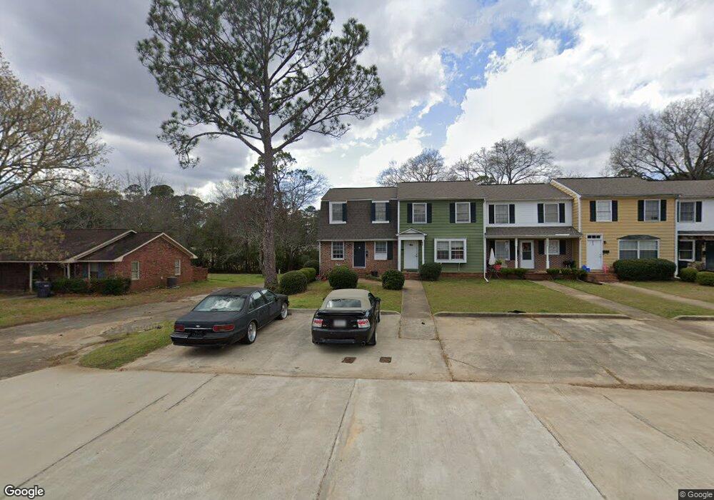
This home is located at 1031 Morningside Dr, Perry, GA 31069 and is currently estimated at $643,403, approximately $618 per square foot. 1031 Morningside Dr is a home located in Houston County with nearby schools including Morningside Elementary School, Perry Middle School, and Perry High School.
Ownership History
Date
Name
Owned For
Owner Type
Purchase Details
Closed on
Oct 7, 2024
Sold by
Htpt Properties Llc
Bought by
Trojan Farms & Real Estate Llc
Current Estimated Value
Home Financials for this Owner
Home Financials are based on the most recent Mortgage that was taken out on this home.
Original Mortgage
$737,886
Outstanding Balance
$526,511
Interest Rate
6.09%
Mortgage Type
New Conventional
Estimated Equity
$116,892
Purchase Details
Closed on
Jul 11, 2017
Sold by
Persons Banking Company
Bought by
Mullins Charles K and Granger Nancy M
Purchase Details
Closed on
Jul 7, 2017
Sold by
Mullins Charles K and Granger Nancy M
Bought by
Toliver Harvey and Toliver Phyllis
Purchase Details
Closed on
Jul 26, 2012
Sold by
Mahoney Richard and Mahoney Brenda
Bought by
Mullins Walter G Jr Estate Trust
Purchase Details
Closed on
Nov 9, 1973
Sold by
Mullins W G
Bought by
Mahoney Richard and Mahoney Brenda
Create a Home Valuation Report for This Property
The Home Valuation Report is an in-depth analysis detailing your home's value as well as a comparison with similar homes in the area
Home Values in the Area
Average Home Value in this Area
Purchase History
| Date | Buyer | Sale Price | Title Company |
|---|---|---|---|
| Trojan Farms & Real Estate Llc | $900,000 | None Listed On Document | |
| Mullins Charles K | -- | None Available | |
| Toliver Harvey | $396,000 | None Available | |
| Mullins Walter G Jr Estate Trust | $30,000 | -- | |
| Mahoney Richard | -- | -- |
Source: Public Records
Mortgage History
| Date | Status | Borrower | Loan Amount |
|---|---|---|---|
| Open | Trojan Farms & Real Estate Llc | $737,886 |
Source: Public Records
Tax History Compared to Growth
Tax History
| Year | Tax Paid | Tax Assessment Tax Assessment Total Assessment is a certain percentage of the fair market value that is determined by local assessors to be the total taxable value of land and additions on the property. | Land | Improvement |
|---|---|---|---|---|
| 2024 | $1,008 | $27,440 | $4,000 | $23,440 |
| 2023 | $919 | $24,840 | $4,000 | $20,840 |
| 2022 | $492 | $21,400 | $3,200 | $18,200 |
| 2021 | $447 | $19,320 | $3,200 | $16,120 |
| 2020 | $444 | $19,120 | $3,200 | $15,920 |
| 2019 | $444 | $19,120 | $3,200 | $15,920 |
| 2018 | $366 | $19,120 | $3,200 | $15,920 |
| 2017 | $445 | $19,120 | $3,200 | $15,920 |
| 2016 | $446 | $19,120 | $3,200 | $15,920 |
| 2015 | $446 | $19,120 | $3,200 | $15,920 |
| 2014 | -- | $19,120 | $3,200 | $15,920 |
| 2013 | -- | $19,120 | $3,200 | $15,920 |
Source: Public Records
Map
Nearby Homes
- 1405 Cambridge Rd
- 1406 Main St
- 1432 Duncan Ave
- 1808 Ross St
- 1152 Lovely Ln
- 1205 Morningside Dr
- 706 Hillcrest Ave
- 117 Constance Ct
- 625 Cooper St
- 118 Constance Ct
- 606 Frank Satterfield Rd
- 1802 Kings Chapel Rd
- 630 Pine Ridge St
- 1304 Davis Ave
- 905 Massee Ln
- 624 Pine Ridge St
- 903 Massee Ln
- 1207 Tucker Rd
- 0 Carroll Aly
- 1212 Swift St
- 1033 Morningside Dr
- 1035 Morningside Dr
- 1011 Morningside Dr
- 1037 Morningside Dr
- 1039 Morningside Dr
- 1041 Morningside Dr
- 1043 Morningside Dr
- 1009 Morningside Dr
- 1045 Morningside Dr
- 1047 Morningside Dr
- 1049 Morningside Dr
- 1008 Talton Place
- 1007 Morningside Dr
- 1006 Talton Place
- 1010 Talton Place
- 1005 Morningside Dr
- 1055 Morningside Dr
- 1002 Talton Place
- 1009 Talton Place
- 1011 Talton Place