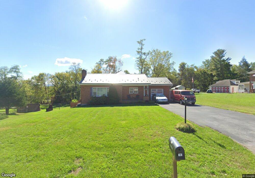
1031 Security Rd Hagerstown, MD 21742
Northeast Hagerstown NeighborhoodEstimated Value: $220,000 - $292,000
Studio
1
Bath
910
Sq Ft
$269/Sq Ft
Est. Value
About This Home
This home is located at 1031 Security Rd, Hagerstown, MD 21742 and is currently estimated at $244,996, approximately $269 per square foot. 1031 Security Rd is a home located in Washington County with nearby schools including Pangborn Elementary School, Northern Middle School, and North Hagerstown High School.
Ownership History
Date
Name
Owned For
Owner Type
Purchase Details
Closed on
Sep 29, 1987
Sold by
Spigler Phillip B and Spigler Gail L
Bought by
Taylor Thomas E
Current Estimated Value
Home Financials for this Owner
Home Financials are based on the most recent Mortgage that was taken out on this home.
Original Mortgage
$64,350
Interest Rate
11.02%
Create a Home Valuation Report for This Property
The Home Valuation Report is an in-depth analysis detailing your home's value as well as a comparison with similar homes in the area
Home Values in the Area
Average Home Value in this Area
Purchase History
| Date | Buyer | Sale Price | Title Company |
|---|---|---|---|
| Taylor Thomas E | $64,900 | -- |
Source: Public Records
Mortgage History
| Date | Status | Borrower | Loan Amount |
|---|---|---|---|
| Closed | Taylor Thomas E | $64,350 |
Source: Public Records
Tax History
| Year | Tax Paid | Tax Assessment Tax Assessment Total Assessment is a certain percentage of the fair market value that is determined by local assessors to be the total taxable value of land and additions on the property. | Land | Improvement |
|---|---|---|---|---|
| 2025 | $974 | $175,267 | $0 | $0 |
| 2024 | $974 | $149,300 | $55,200 | $94,100 |
| 2023 | $1,033 | $142,367 | $0 | $0 |
| 2022 | $919 | $135,433 | $0 | $0 |
| 2021 | $1,338 | $128,500 | $55,200 | $73,300 |
| 2020 | $1,338 | $126,833 | $0 | $0 |
| 2019 | $1,327 | $125,167 | $0 | $0 |
| 2018 | $1,309 | $123,500 | $55,200 | $68,300 |
| 2017 | $1,309 | $123,500 | $0 | $0 |
| 2016 | -- | $123,500 | $0 | $0 |
| 2015 | $1,566 | $128,800 | $0 | $0 |
| 2014 | $1,566 | $128,800 | $0 | $0 |
Source: Public Records
Map
Nearby Homes
- 313 Sunbrook Ln Unit 95
- 319 Sunbrook Ln Unit 98
- 340 Sunbrook Ln
- 486 Antietam Dr
- 43 Sunbrook Ln Unit 6
- 344 Hollymead Terrace
- 466 Pangborn Blvd
- 1023 Klick Way
- 1056 Valleybrook Dr
- 942 Monet Dr
- 1001 Jefferson Blvd
- 1275 Jefferson Blvd
- 752 Monet Dr
- 0 Jefferson Blvd Unit MDWA2032528
- 953 View St
- 232 E Irvin Ave
- 207 E Irvin Ave
- 713 Medway Rd
- 939 View St
- 21 Carriage Hill Dr
- 1039 Security Rd
- 1025 Security Rd
- 1043 Security Rd
- 1036 Security Rd
- 1034 Security Rd
- 1015 Security Rd
- 1038 Security Rd
- 1045 Security Rd
- 1040 Security Rd
- 1005 Security Rd
- 1042 Security Rd
- 1049 Security Rd
- 1046 Security Rd
- 1001 Security Rd
- 1000 Security Rd
- 1051 Security Rd
- 1050 Security Rd
- 950 Security Rd
- 1052 Security Rd
- 443 Antietam Dr
Your Personal Tour Guide
Ask me questions while you tour the home.