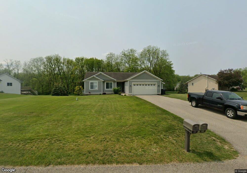
10317 Mulberry Dr Unit 36 Middleville, MI 49333
Estimated Value: $344,393 - $403,000
3
Beds
2
Baths
1,268
Sq Ft
$297/Sq Ft
Est. Value
About This Home
This home is located at 10317 Mulberry Dr Unit 36, Middleville, MI 49333 and is currently estimated at $376,348, approximately $296 per square foot. 10317 Mulberry Dr Unit 36 is a home located in Barry County with nearby schools including McFall Elementary School, Page Elementary School, and Lee Elementary School.
Ownership History
Date
Name
Owned For
Owner Type
Purchase Details
Closed on
Sep 8, 2006
Sold by
Bouma Building & Development Inc
Bought by
Robirds Peter and Robirds Rebecca
Current Estimated Value
Home Financials for this Owner
Home Financials are based on the most recent Mortgage that was taken out on this home.
Original Mortgage
$174,166
Outstanding Balance
$104,137
Interest Rate
6.59%
Mortgage Type
FHA
Estimated Equity
$272,211
Create a Home Valuation Report for This Property
The Home Valuation Report is an in-depth analysis detailing your home's value as well as a comparison with similar homes in the area
Home Values in the Area
Average Home Value in this Area
Purchase History
| Date | Buyer | Sale Price | Title Company |
|---|---|---|---|
| Robirds Peter | $176,900 | Metropolitan Title Company |
Source: Public Records
Mortgage History
| Date | Status | Borrower | Loan Amount |
|---|---|---|---|
| Open | Robirds Peter | $174,166 |
Source: Public Records
Tax History Compared to Growth
Tax History
| Year | Tax Paid | Tax Assessment Tax Assessment Total Assessment is a certain percentage of the fair market value that is determined by local assessors to be the total taxable value of land and additions on the property. | Land | Improvement |
|---|---|---|---|---|
| 2025 | $2,951 | $142,300 | $0 | $0 |
| 2024 | $2,951 | $133,800 | $0 | $0 |
| 2023 | $2,688 | $106,100 | $0 | $0 |
| 2022 | $2,688 | $106,100 | $0 | $0 |
| 2021 | $2,688 | $100,300 | $0 | $0 |
| 2020 | $2,645 | $94,500 | $0 | $0 |
| 2019 | $2,645 | $91,800 | $0 | $0 |
| 2018 | $2,555 | $85,600 | $14,500 | $71,100 |
| 2017 | $2,555 | $85,600 | $0 | $0 |
| 2016 | -- | $74,700 | $0 | $0 |
| 2015 | -- | $72,100 | $0 | $0 |
| 2014 | -- | $72,100 | $0 | $0 |
Source: Public Records
Map
Nearby Homes
- 5156 Ravine Dr
- 451 Oak View Dr
- 379 Minstehr Dr
- 886 Oak Wind Ct
- 5325 Stimson Rd
- 210 Meadowlark Ct
- Wilshire Plan at Seneca Ridge
- Remington Plan at Seneca Ridge
- Linden Plan at Seneca Ridge
- Enclave Plan at Seneca Ridge
- Croswell Plan at Seneca Ridge
- Cascade Plan at Seneca Ridge
- Carson Plan at Seneca Ridge
- Avery Plan at Seneca Ridge
- Ashton Plan at Seneca Ridge
- Andover Plan at Seneca Ridge
- 313 Seneca Ridge Dr Unit 45
- 343 Seneca Ridge Dr Unit 40
- 319 Seneca Ridge Dr Unit 44
- 3770 Bender Rd
- 10329 Mulberry Dr Unit 35
- 10303 Mulberry Dr Unit 37
- 10318 Mulberry Dr Unit 30
- 10341 Mulberry Dr Unit 34
- 10306 Mulberry Dr Unit 29
- 10330 Mulberry Dr Unit 31
- 10281 Mulberry Dr
- 10369 Mulberry Dr Unit 33
- 10291 Cottonwood Ct
- 10374 Mulberry Dr Unit 32
- 4653 Hemlock Ct Unit 13
- 4677 Hemlock Ct Unit 12
- 10289 Mulberry Dr Unit 15
- 4625 Hemlock Ct Unit 14
- 0 Cottonwood Ct Unit M14016231
- 0 Cottonwood Ct Unit M17000648
- 0 Cottonwood Ct Unit 65014016231
- 0 Cottonwood Ct Unit 41
- 4701 Hemlock Ct Unit 11
- 4603 Juneberry Ct Unit 16