Estimated Value: $924,000 - $972,000
5
Beds
4
Baths
3,311
Sq Ft
$285/Sq Ft
Est. Value
About This Home
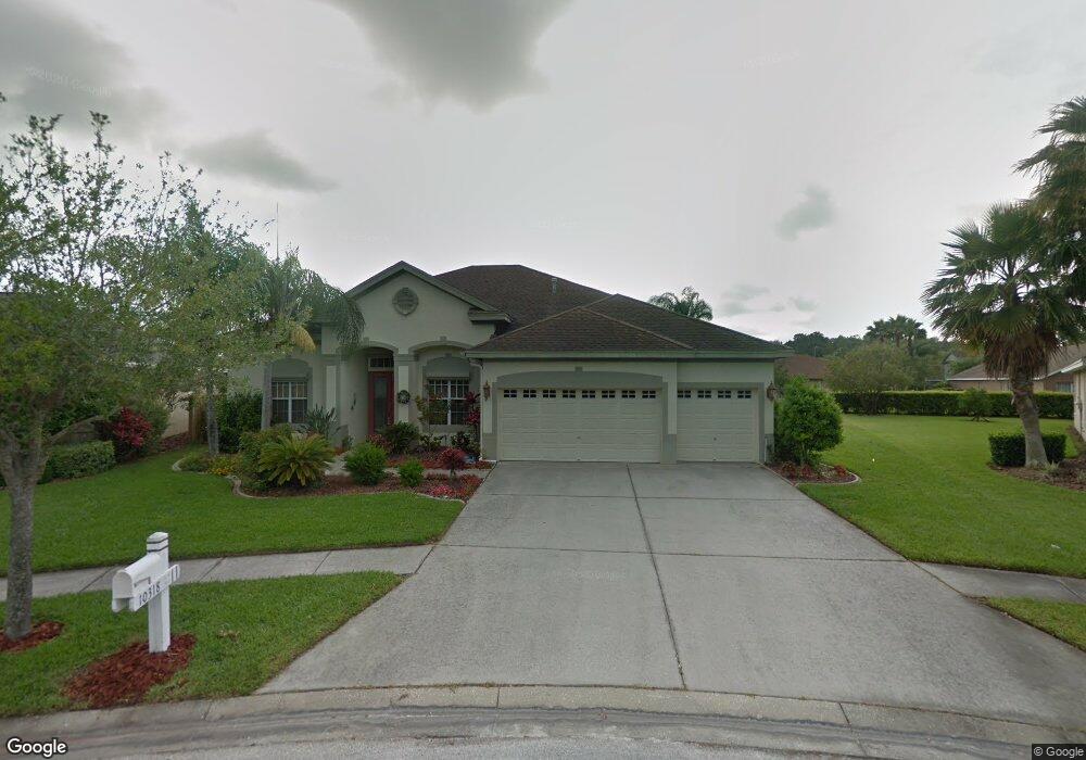
This home is located at 10318 Millport Dr, Tampa, FL 33626 and is currently estimated at $944,965, approximately $285 per square foot. 10318 Millport Dr is a home located in Hillsborough County with nearby schools including Westchase Elementary School, Davidsen Middle School, and Alonso High School.
Ownership History
Date
Name
Owned For
Owner Type
Purchase Details
Closed on
Sep 25, 2017
Sold by
Hackney Harold D
Bought by
Chemelir Stephen M and Chemelir Jeanette M
Current Estimated Value
Home Financials for this Owner
Home Financials are based on the most recent Mortgage that was taken out on this home.
Original Mortgage
$513,000
Outstanding Balance
$428,039
Interest Rate
3.78%
Mortgage Type
New Conventional
Estimated Equity
$516,926
Purchase Details
Closed on
Nov 6, 1996
Sold by
The Ryland Group Inc
Bought by
Hackney Harold D and Hackney Ottilie M
Create a Home Valuation Report for This Property
The Home Valuation Report is an in-depth analysis detailing your home's value as well as a comparison with similar homes in the area
Home Values in the Area
Average Home Value in this Area
Purchase History
| Date | Buyer | Sale Price | Title Company |
|---|---|---|---|
| Chemelir Stephen M | $570,000 | First Title Source Llc | |
| Hackney Harold D | $203,200 | -- |
Source: Public Records
Mortgage History
| Date | Status | Borrower | Loan Amount |
|---|---|---|---|
| Open | Chemelir Stephen M | $513,000 |
Source: Public Records
Tax History Compared to Growth
Tax History
| Year | Tax Paid | Tax Assessment Tax Assessment Total Assessment is a certain percentage of the fair market value that is determined by local assessors to be the total taxable value of land and additions on the property. | Land | Improvement |
|---|---|---|---|---|
| 2024 | $8,047 | $425,104 | -- | -- |
| 2023 | $7,784 | $412,722 | $0 | $0 |
| 2022 | $7,398 | $400,701 | $0 | $0 |
| 2021 | $7,293 | $389,030 | $0 | $0 |
| 2020 | $7,187 | $383,659 | $0 | $0 |
| 2019 | $7,040 | $375,033 | $0 | $0 |
| 2018 | $6,981 | $368,040 | $0 | $0 |
| 2017 | $5,658 | $409,622 | $0 | $0 |
| 2016 | $5,741 | $278,456 | $0 | $0 |
| 2015 | $5,892 | $276,520 | $0 | $0 |
| 2014 | $5,865 | $274,325 | $0 | $0 |
| 2013 | -- | $270,271 | $0 | $0 |
Source: Public Records
Map
Nearby Homes
- 10409 Lightner Bridge Dr
- 10364 Lightner Bridge Dr
- 10232 Millport Dr
- 10502 Castleford Way
- 10455 Green Links Dr
- 10605 Tavistock Dr
- 10136 Kingsbridge Ave
- 10309 Marchmont Ct
- 9986 Stockbridge Dr
- 10639 Gretna Green Dr
- 10026 Seymour Way
- 10001 Seymour Way
- 10021 Brompton Dr
- 11506 Crowned Sparrow Ln
- 11424 Crowned Sparrow Ln
- 11604 Crowned Sparrow Ln
- 9237 Fox Sparrow Rd
- 9248 Fox Sparrow Rd
- 10552 Greencrest Dr
- 11617 Crowned Sparrow Ln
- 10316 Millport Dr
- 10320 Millport Dr
- 10315 Seabridge Way
- 10314 Millport Dr
- 10314 Seabridge Way
- 10322 Millport Dr
- 10321 Millport Dr
- 10313 Seabridge Way
- 10307 Millport Dr
- 10324 Millport Dr
- 10312 Millport Dr
- 10311 Seabridge Way
- 10323 Millport Dr
- 10305 Millport Dr
- 10326 Millport Dr
- 10301 Millport Dr
- 10307 Seabridge Way
- 10401 Lightner Bridge Dr
- 10369 Lightner Bridge Dr
- 10308 Seabridge Way