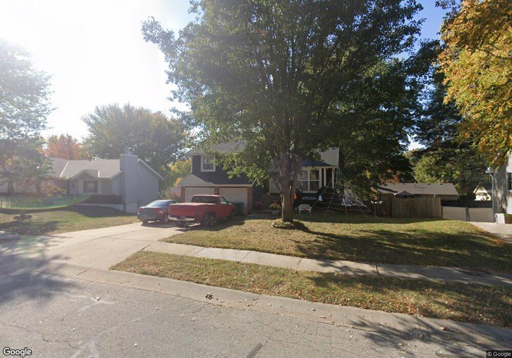
1032 Bristol Way Liberty, MO 64068
Estimated Value: $277,771 - $303,000
3
Beds
2
Baths
1,041
Sq Ft
$278/Sq Ft
Est. Value
About This Home
This home is located at 1032 Bristol Way, Liberty, MO 64068 and is currently estimated at $289,443, approximately $278 per square foot. 1032 Bristol Way is a home located in Clay County with nearby schools including Alexander Doniphan Elementary School, Liberty Middle School, and Liberty High School.
Ownership History
Date
Name
Owned For
Owner Type
Purchase Details
Closed on
Mar 6, 2006
Sold by
Scott Leticia and Scott Jeffrey
Bought by
Scott Jeffrey and Scott Leticia
Current Estimated Value
Home Financials for this Owner
Home Financials are based on the most recent Mortgage that was taken out on this home.
Original Mortgage
$25,000
Interest Rate
6.19%
Mortgage Type
Credit Line Revolving
Purchase Details
Closed on
Feb 2, 2004
Sold by
Scott Leticia and Scott Jeffrey
Bought by
Scott Jeffrey and Scott Leticia
Create a Home Valuation Report for This Property
The Home Valuation Report is an in-depth analysis detailing your home's value as well as a comparison with similar homes in the area
Home Values in the Area
Average Home Value in this Area
Purchase History
| Date | Buyer | Sale Price | Title Company |
|---|---|---|---|
| Scott Jeffrey | -- | None Available | |
| Scott Jeffrey | -- | -- |
Source: Public Records
Mortgage History
| Date | Status | Borrower | Loan Amount |
|---|---|---|---|
| Closed | Scott Jeffrey | $25,000 |
Source: Public Records
Tax History Compared to Growth
Tax History
| Year | Tax Paid | Tax Assessment Tax Assessment Total Assessment is a certain percentage of the fair market value that is determined by local assessors to be the total taxable value of land and additions on the property. | Land | Improvement |
|---|---|---|---|---|
| 2025 | $2,526 | $37,750 | -- | -- |
| 2024 | $2,526 | $32,850 | -- | -- |
| 2023 | $2,569 | $32,850 | $0 | $0 |
| 2022 | $2,328 | $29,390 | $0 | $0 |
| 2021 | $2,310 | $29,393 | $7,220 | $22,173 |
| 2020 | $2,094 | $25,020 | $0 | $0 |
| 2019 | $2,094 | $25,020 | $0 | $0 |
| 2018 | $1,953 | $22,910 | $0 | $0 |
| 2017 | $1,935 | $22,910 | $4,560 | $18,350 |
| 2016 | $1,935 | $22,910 | $4,560 | $18,350 |
| 2015 | $1,935 | $22,910 | $4,560 | $18,350 |
| 2014 | $1,837 | $21,580 | $4,370 | $17,210 |
Source: Public Records
Map
Nearby Homes
- 1105 Bristol Way
- 1124 Amesbury Ave
- 918 Amesbury Ave
- 862 Amesbury Ave
- 1218 Canterbury Ln
- 1323 Amesbury Ave
- 716 Bristol Ct
- 1331 Park Ln
- 1317 Park Ln
- 1507 Amesbury Ave
- 415 Monterey Ave
- 1304 Wellington Way
- 509 Belmont St
- 1209 Liberty Drive Terrace
- 1537 Canterbury Ln
- 1733 Welleslay Ln
- 1327 Easton Ct
- 420 Belmont St
- 1025 Orchard Ave
- 1030 Maple Woods Dr
- 1038 Bristol Way
- 1026 Bristol Way
- 1031 Amesbury Ave
- 1037 Amesbury Ave
- 1025 Amesbury Ave
- 1044 Bristol Way
- 1020 Bristol Way
- 1101 Amesbury Ave
- 1033 Bristol Way
- 1019 Amesbury Ave
- 1027 Bristol Way
- 1039 Bristol Way
- 1100 Bristol Way
- 1014 Bristol Way
- 1021 Bristol Way
- 1107 Amesbury Ave
- 1013 Amesbury Ave
- 1045 Bristol Way
- 1015 Bristol Way
- 1106 Bristol Way