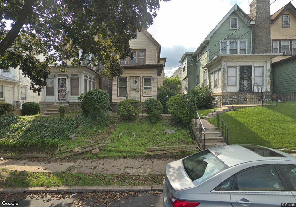
1032 Bullock Ave Lansdowne, PA 19050
Estimated Value: $148,000 - $279,000
3
Beds
2
Baths
1,842
Sq Ft
$130/Sq Ft
Est. Value
About This Home
This home is located at 1032 Bullock Ave, Lansdowne, PA 19050 and is currently estimated at $238,598, approximately $129 per square foot. 1032 Bullock Ave is a home located in Delaware County with nearby schools including Bell Avenue Elementary School, Penn Wood Middle School, and Penn Wood High School - Cypress Street Campus.
Ownership History
Date
Name
Owned For
Owner Type
Purchase Details
Closed on
Jun 24, 2022
Sold by
Abdulai Conteh
Bought by
Kamara Zainab and Kamera Rngiatu
Current Estimated Value
Purchase Details
Closed on
Dec 12, 2017
Sold by
Marah Denka
Bought by
Conteh Abdulai
Home Financials for this Owner
Home Financials are based on the most recent Mortgage that was taken out on this home.
Original Mortgage
$132,554
Interest Rate
4.37%
Mortgage Type
FHA
Purchase Details
Closed on
Sep 17, 2002
Sold by
Scott Michael L and Scott Vanessa H
Bought by
Marah Denka
Home Financials for this Owner
Home Financials are based on the most recent Mortgage that was taken out on this home.
Original Mortgage
$90,600
Interest Rate
6.25%
Mortgage Type
FHA
Create a Home Valuation Report for This Property
The Home Valuation Report is an in-depth analysis detailing your home's value as well as a comparison with similar homes in the area
Home Values in the Area
Average Home Value in this Area
Purchase History
| Date | Buyer | Sale Price | Title Company |
|---|---|---|---|
| Kamara Zainab | $112,500 | My Philly Abstract | |
| Conteh Abdulai | $135,000 | Nationwide Title Clearing | |
| Marah Denka | $91,400 | Fidelity Natl Title Ins Co O |
Source: Public Records
Mortgage History
| Date | Status | Borrower | Loan Amount |
|---|---|---|---|
| Previous Owner | Conteh Abdulai | $132,554 | |
| Previous Owner | Marah Denka | $90,600 |
Source: Public Records
Tax History Compared to Growth
Tax History
| Year | Tax Paid | Tax Assessment Tax Assessment Total Assessment is a certain percentage of the fair market value that is determined by local assessors to be the total taxable value of land and additions on the property. | Land | Improvement |
|---|---|---|---|---|
| 2025 | $5,669 | $132,770 | $32,370 | $100,400 |
| 2024 | $5,669 | $132,770 | $32,370 | $100,400 |
| 2023 | $5,149 | $132,770 | $32,370 | $100,400 |
| 2022 | $4,910 | $132,770 | $32,370 | $100,400 |
| 2021 | $7,424 | $132,770 | $32,370 | $100,400 |
| 2020 | $4,633 | $74,190 | $18,680 | $55,510 |
| 2019 | $4,552 | $74,190 | $18,680 | $55,510 |
| 2018 | $4,488 | $74,190 | $0 | $0 |
| 2017 | $4,394 | $74,190 | $0 | $0 |
| 2016 | $407 | $74,190 | $0 | $0 |
| 2015 | $407 | $74,190 | $0 | $0 |
| 2014 | $407 | $74,190 | $0 | $0 |
Source: Public Records
Map
Nearby Homes
- 1049 Yeadon Ave
- 939 Serrill Ave
- 921 Serrill Ave
- 6951 Chester Ave
- 6718 Cobbs Creek Pkwy
- 6835 Chester Ave
- 923 Bell Ave
- 908 Yeadon Ave
- 6535 Windsor St
- 808 Serrill Ave
- 6564 Belmar St
- 825 Laurel Rd
- 1781 S 65th St
- 800 Bullock Ave
- 813 Arbor Rd
- 1824 S 65th St
- 2032 S 68th St
- 740 Church Ln
- 2030 S 67th St
- 7036 Greenway Ave
- 1034 Bullock Ave
- 1030 Bullock Ave
- 1036 Bullock Ave
- 1028 Bullock Ave
- 1038 Bullock Ave
- 1026 Bullock Ave
- 1040 Bullock Ave
- 1024 Bullock Ave
- 1033 Yeadon Ave
- 1035 Yeadon Ave
- 1031 Yeadon Ave
- 1029 Yeadon Ave
- 1037 Yeadon Ave
- 1042 Bullock Ave
- 1022 Bullock Ave
- 1039 Yeadon Ave
- 1027 Yeadon Ave
- 1041 Yeadon Ave
- 1025 Yeadon Ave
- 1044 Bullock Ave