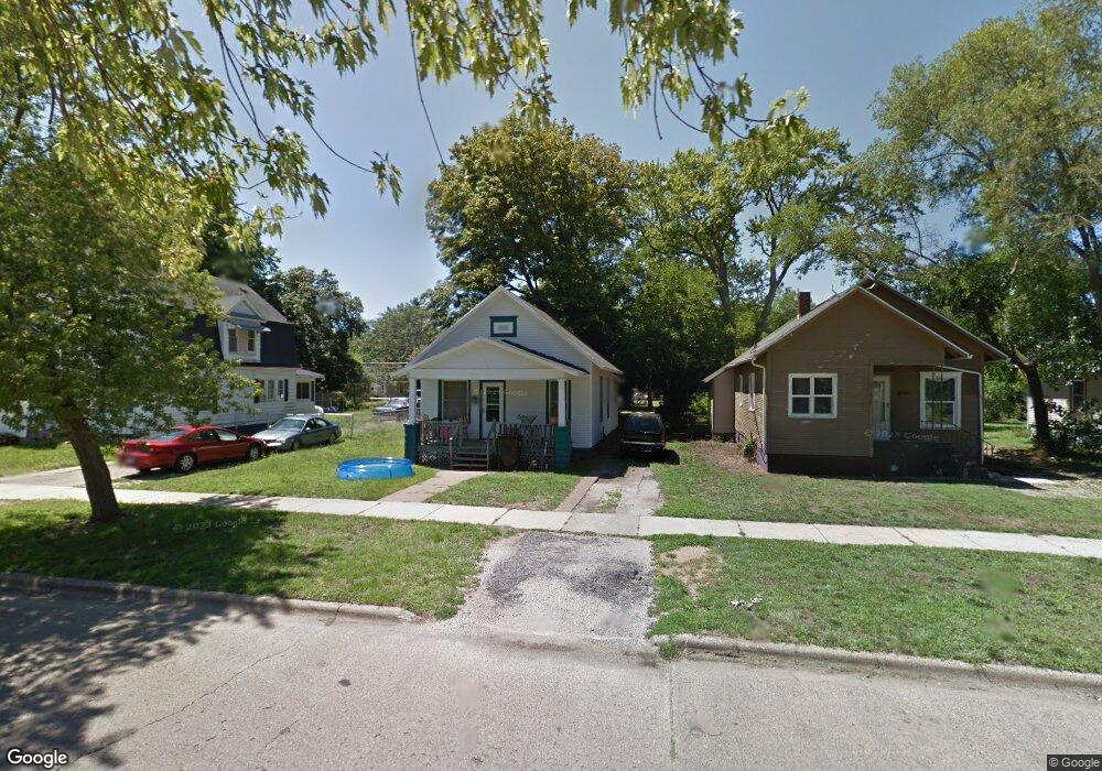
1032 Columbus Ave Benton Harbor, MI 49022
Estimated Value: $64,000 - $99,000
2
Beds
1
Bath
825
Sq Ft
$92/Sq Ft
Est. Value
About This Home
This home is located at 1032 Columbus Ave, Benton Harbor, MI 49022 and is currently estimated at $75,680, approximately $91 per square foot. 1032 Columbus Ave is a home located in Berrien County with nearby schools including Fair Plain Middle School, Benton Harbor High School, and Benton Harbor Charter School Academy.
Ownership History
Date
Name
Owned For
Owner Type
Purchase Details
Closed on
Mar 5, 2004
Sold by
Chemical Bank Shoreline
Bought by
Bushert Kip and Bushert Chanta L
Current Estimated Value
Home Financials for this Owner
Home Financials are based on the most recent Mortgage that was taken out on this home.
Original Mortgage
$9,600
Interest Rate
5.77%
Mortgage Type
Unknown
Purchase Details
Closed on
Apr 17, 2003
Sold by
Davis Fred
Bought by
Chemical Bank Shoreline and Shoreline Bank
Purchase Details
Closed on
Jul 1, 2002
Purchase Details
Closed on
Oct 15, 2001
Purchase Details
Closed on
Nov 17, 1999
Create a Home Valuation Report for This Property
The Home Valuation Report is an in-depth analysis detailing your home's value as well as a comparison with similar homes in the area
Home Values in the Area
Average Home Value in this Area
Purchase History
| Date | Buyer | Sale Price | Title Company |
|---|---|---|---|
| Bushert Kip | -- | Metropolitan Title Company | |
| Chemical Bank Shoreline | $15,000 | -- | |
| -- | -- | -- | |
| -- | -- | -- | |
| -- | $156,000 | -- |
Source: Public Records
Mortgage History
| Date | Status | Borrower | Loan Amount |
|---|---|---|---|
| Closed | Bushert Kip | $9,600 |
Source: Public Records
Tax History Compared to Growth
Tax History
| Year | Tax Paid | Tax Assessment Tax Assessment Total Assessment is a certain percentage of the fair market value that is determined by local assessors to be the total taxable value of land and additions on the property. | Land | Improvement |
|---|---|---|---|---|
| 2025 | $702 | $23,700 | $0 | $0 |
| 2024 | $676 | $20,900 | $0 | $0 |
| 2023 | $540 | $14,500 | $0 | $0 |
| 2022 | $613 | $10,900 | $0 | $0 |
| 2021 | $617 | $10,900 | $700 | $10,200 |
| 2020 | $610 | $11,100 | $0 | $0 |
| 2019 | $599 | $10,000 | $0 | $0 |
| 2018 | $597 | $9,300 | $0 | $0 |
| 2017 | $916 | $14,900 | $0 | $0 |
| 2016 | $901 | $15,000 | $0 | $0 |
| 2015 | $899 | $14,400 | $0 | $0 |
| 2014 | $976 | $17,500 | $0 | $0 |
Source: Public Records
Map
Nearby Homes
- 361 E May St
- 1097 Pearl St
- 972 Pearl St
- 349 E Empire Ave
- 833 Pearl St
- 960 Jennings Ave
- 1219 Ogden Ave
- 979 Lavette Ave
- 1267 Broadway
- 872 Mcalister Ave
- 1129 Jennings Ave
- 1045 Broadway
- 171 E Empire Ave
- 1142 Bishop Ave
- 941 Colfax Ave
- 1301 Superior St
- 1332 Columbus Ave
- 730 Superior St
- 960 Union Ave
- 1235 Colfax Ave
- 1026 Columbus Ave
- 1040 Columbus Ave
- 1018 Columbus Ave
- 1050 Columbus Ave
- 1010 Columbus Ave
- 1017 Columbus Ave
- 1049 Pearl St
- 1019 Pearl St
- 1019 Pearl St
- 1033 Pearl St
- 1056 Columbus Ave
- 1037 Pearl St
- 1035 Columbus Ave
- 1039 Columbus Ave
- 1060 Columbus Ave
- 1027 Columbus Ave
- 1011 Pearl St
- 1049 Columbus Ave
- 1011 Columbus Ave
- 1057 Pearl St