
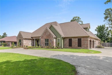
1032 Tan Tara Cir Lake Charles, LA 70611
Moss Bluff NeighborhoodEstimated payment $3,177/month
Highlights
- In Ground Pool
- Second Garage
- Attic
- Moss Bluff Elementary School Rated A-
- Custom Home
- Granite Countertops
About This Home
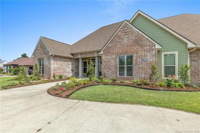
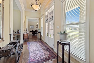
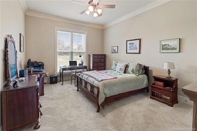
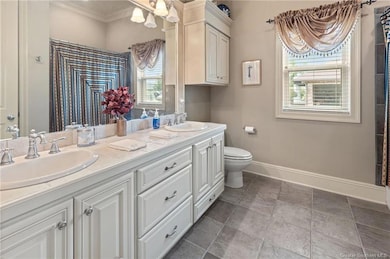
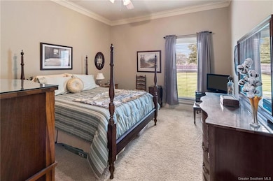
This custom-built and impeccably maintained 4-bedroom, 3 full and 2 half.5-bath home combines thoughtful design, quality finishes. Constructed in 2004, it features 12-foot ceilings in the main living areas, triple crown, and abundant natural light throughout. The kitchen offers both functionality and style, complete with granite countertops, a spacious island with bar seating, a propane range, with double oven, and generous cabinet storage. It flows seamlessly into a cozy breakfast nook and a formal dining room ideal for entertaining. The living room includes custom built-ins, surround sound, and a propane fireplace--ideal for relaxed evenings at home. The primary suite boasts hardwood flooring, a walk-in closet with built-ins, and a luxurious ensuite featuring double vanities, a soaking tub, walk-in shower maxed out built-ins in the walk-in closet. Two guest bedrooms share a double-vanity bath, while the upstairs bonus room--with its own full bath--serves well as a fourth bedroom, office, or flex space. Outside, enjoy a fully fenced backyard with a 6-foot saltwater pool (new liner in 2020; new pump and salt system in 2025), a covered patio with fans, and a built-in propane hookup for grilling. The attached three-car garage encompasses a bay which can be used for a workshop and/or golf cart storage and includes a half bath and kitchenette--perfect for guests, hobbies, or entertaining. Additional highlights include a spacious laundry room with utility sink, a two-car garage with storage.. Conveniently located near dining, shopping, and schools. This property offers the complete package--comfort, space, and timeless style. Schedule your private showing today. Flood Zone: X, Annual property tax: $2696; No HOA Dues. The seller is providing an APHW "Supreme" Home Warranty; see supplements!
Home Details
Home Type
- Single Family
Est. Annual Taxes
- $2,697
Year Built
- 2004
Lot Details
- 0.6 Acre Lot
- Privacy Fence
- Wood Fence
- Landscaped
- Rectangular Lot
Home Design
- Custom Home
- Acadian Style Architecture
- Brick Exterior Construction
- Slab Foundation
- Shingle Roof
Interior Spaces
- 2-Story Property
- Central Vacuum
- Built-In Features
- Crown Molding
- Ceiling Fan
- Recessed Lighting
- Propane Fireplace
- Neighborhood Views
- Laundry Room
- Attic
Kitchen
- Kitchenette
- Breakfast Area or Nook
- Double Oven
- Gas Range
- Microwave
- Freezer
- Dishwasher
- Kitchen Island
- Granite Countertops
- Disposal
Bedrooms and Bathrooms
- 2 Bathrooms
- Single Vanity
- Dual Sinks
- Soaking Tub
- Separate Shower
Parking
- Garage
- Second Garage
- Oversized Parking
- Circular Driveway
- Open Parking
Pool
- In Ground Pool
- Vinyl Pool
Outdoor Features
- Covered Patio or Porch
- Exterior Lighting
Location
- Outside City Limits
Schools
- Moss Bluff Elementary And Middle School
- Sam Houston High School
Utilities
- Central Heating and Cooling System
- Aerobic Septic System
Community Details
- No Home Owners Association
- Indian Acres Subdivision
Map
Home Values in the Area
Average Home Value in this Area
Tax History
| Year | Tax Paid | Tax Assessment Tax Assessment Total Assessment is a certain percentage of the fair market value that is determined by local assessors to be the total taxable value of land and additions on the property. | Land | Improvement |
|---|---|---|---|---|
| 2024 | $2,697 | $32,590 | $3,240 | $29,350 |
| 2023 | $2,697 | $32,590 | $3,240 | $29,350 |
| 2022 | $2,651 | $32,590 | $3,240 | $29,350 |
| 2021 | $2,782 | $32,590 | $3,240 | $29,350 |
| 2020 | $3,215 | $29,530 | $3,110 | $26,420 |
| 2019 | $3,535 | $32,350 | $3,000 | $29,350 |
| 2018 | $2,720 | $32,350 | $3,000 | $29,350 |
| 2017 | $3,590 | $32,350 | $3,000 | $29,350 |
| 2016 | $3,011 | $32,350 | $3,000 | $29,350 |
| 2015 | $3,011 | $29,460 | $3,300 | $26,160 |
Property History
| Date | Event | Price | List to Sale | Price per Sq Ft |
|---|---|---|---|---|
| 09/19/2025 09/19/25 | Price Changed | $560,000 | -2.6% | $164 / Sq Ft |
| 07/28/2025 07/28/25 | Price Changed | $575,000 | -0.9% | $169 / Sq Ft |
| 07/08/2025 07/08/25 | For Sale | $580,000 | -- | $170 / Sq Ft |
Purchase History
| Date | Type | Sale Price | Title Company |
|---|---|---|---|
| Deed | $367,500 | None Available |
Mortgage History
| Date | Status | Loan Amount | Loan Type |
|---|---|---|---|
| Open | $294,000 | New Conventional |
Source: Southwest Louisiana Association of REALTORS®
MLS Number: SWL25003889
APN: 00821950
- 0 Sam Houston Jones Pkwy Unit SWL22006961
- 0 Sam Houston Jones Pkwy Unit 145953
- 1208 Sam Houston Joness Pkwy
- 125 Thelma Ln
- 0 Jones Rd
- 0 Cooley Rd Unit SWL25000721
- 833 N Huval Dr
- 863 Cooley Rd
- 724 N Huval Dr
- 234 Reeves Rd
- 1492 Becky St
- 1156 Sistrunk Rd
- 1485 Tomahawk Dr
- 0 Champagne Cir Unit SWL23007471
- 1630 Hollow Cove Ln
- 0 Park Rd
- 0 Park Rd Unit SWL25002774
- 1647 Hollow Cove
- 290 Morrow Rd
- 647 Morrow Rd
- 444 Andrus Loop
- 233 Armistead Ln Unit A
- 876 Gold Finch Way
- 1624 N Michael Square
- 2900 Westwood Rd
- 608 John Stine Rd Unit 608 John Stine Rd duplex
- 5004 Cypress Lake Dr
- 1205 Beech St
- 2600 Moeling St
- 2013 Elizabeth St
- 420 Moss St Unit A
- 420 Moss St
- 420 Moss St Unit A
- 333 Mill St
- 600 Ryan St
- 401 Division St
- 707 Division St Unit B
- 805 Topsy Rd
- 2403 Elaine St
- 3728 E Opelousas St Unit C
