NOT LISTED FOR SALE

10322 E Highway 156 West Fork, AR 72774

Estimated Value: $172,776 - $421,000

66 Acres
$4,312 Price per Acre
2,874,960 Sq Ft Lot

Last Sold July 06, 2022

Last sale price $450,000 $1,705 Per Sq Ft

Est. 37% decrease in value since last sale

Current estimated payment $1,576/month

5 Days on Market

Highlights

  • 66 Acre Lot
  • Creek or Stream
  • Lot Has A Rolling Slope
  • Wooded Lot
  • Partially Fenced Property

About This Lot

As of July 2022

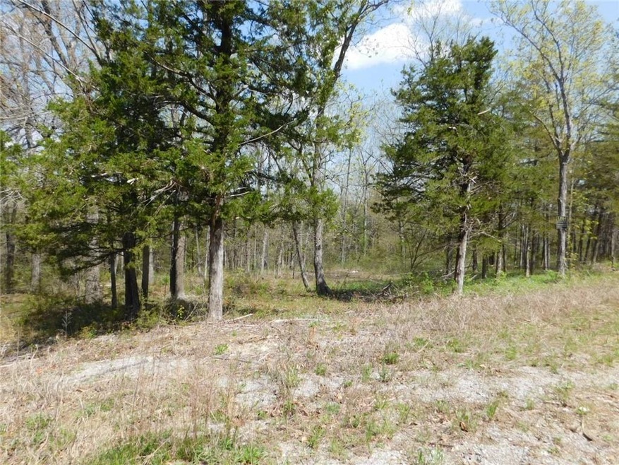
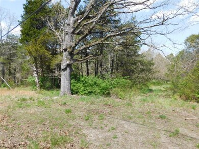
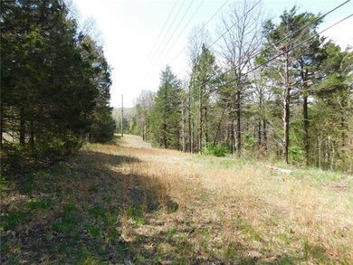
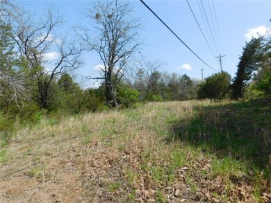
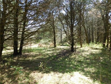
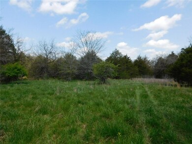
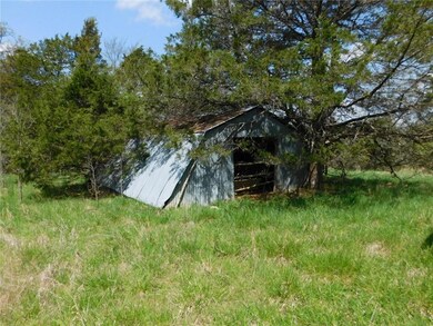
Fantastic 66 acres (mol) on paved highway within 1/2 mile of I-49. This parcel offers one great location, views to be had, numerous potential uses, a creek on the north end, ponds, an old barn, lots of woods, and plenty of wildlife. A 6-acre corner of the 66-acre parcel is on the left (south) side of the highway, and the right (north) side is basically 60 acres. There is an abandoned and rundown home on each side of the highway, a water tap located on the north side, electricity across the front of the north side, and lots more! Sold AS-IS. This land has been owned by the same family since 1956. No survey available

Last Agent to Sell the Property

Neil Adams

Legend Realty Inc License #EB00071885 Listed on: 05/10/2022

Last Buyer's Agent

Terri McNaughton

McNaughton Real Estate License #PB00001140

Property Details

Property Type

  • Land

Est. Annual Taxes

  • $568

Lot Details

  • 66 Acre Lot
  • Creek or Stream
  • Rural Setting
  • South Facing Home
  • Partially Fenced Property
  • Wire Fence
  • Lot Has A Rolling Slope
  • Wooded Lot
  • Landscaped with Trees

Home Design

  • Mixed Use

Utilities

  • Natural Gas Not Available
  • Septic Needed

Additional Features

  • Outside City Limits
  • Mobile Home Allowed

Community Details

  • 06 14 30 Subdivision

Property Details

Property Type

Land

Est. Annual Taxes

$568

Lot Details

0

Listing Details

  • Property Sub Type: Mixed Use
  • Prop. Type: Land
  • Lot Size Acres: 66.0
  • Lot Size: 66 AC; irreg
  • Road Frontage Type: Public Road
  • Road Surface Type: Paved
  • Subdivision Name: 06-14-30
  • Directions: From I-49, take West Fork Exit 53, then west on Hwy 170, then immediate right on Hwy 156. Property begins on the right approximately 500 yards down Hwy 156.
  • ResoPropertyType: Land
  • Property Sub Type Additional: Mixed Use
  • Special Features: VirtualTour

Interior Features

  • Possible Use: Agricultural, Development, Mixed Use, Recreational, Residential

Exterior Features

  • Fencing: Partial, Wire
  • Lot Features: Hardwood Trees, Mobile Home Allowed, Not In Subdivision, Outside City Limits, Rolling Slope, Rural Lot, Stream/Creek, Wooded
  • Topography: Rolling
  • Direction Faces: South

Utilities

  • Electricity On Property: Yes
  • Sewer: Septic Needed
  • Utilities: Natural Gas Not Available, Electricity Available
  • Water Source: Public

Schools

  • Junior High Dist: West Fork

Lot Info

  • Zoning: N
  • ResoLotSizeUnits: Acres

Tax Info

  • Tax Annual Amount: 568.0
  • Tax Block: 0
  • Tax Lot: 0

Ownership History

Date Name Owned For Owner Type

Purchase Details

Closed on
Nov 3, 2022
Sold by
Orsburne Family Trust
Bought by
Morrell Jimmy and Orsburne Christine
Current Estimated Value
$284,592

Purchase Details

Closed on
Jul 10, 2020
Sold by
Copeland Steven
Bought by
Copeland Steven and Copeland David

Purchase Details

Closed on
Jan 1, 1985
Bought by
Downing Pearl R
Source: Public Records

Range of Values:

Collateral Analytics

Collateral Analytics Collateral Analytics AVMs (Automated Valuation Model) employ a number of statistical approaches combined with neighborhood-specific comparable selection guarantees the most up-to-date and precise valuations.

Not Available

Collateral Analytics does not have data for the current month. Please view the chart for historical values.

ICE

ICE Mortgage Technology ICE Mortgage Technology’s AVM (Automated Valuation Model) is a state-of-the-art online residential property valuation tool that provides a quick and accurate estimate of the value of almost any home in the U.S.

Not Available

ICE Mortgage Technology does not have data for the current month. Please view the chart for historical values.

First American

First American First American Data & Analytics’ next-generation AVM combines unrivaled data assets with a blended ensemble of valuation models to produce highly accurate, reliable valuations you can trust.

Not Available

First American does not have data for the current month. Please view the chart for historical values.

Quantarium

Quantarium Quantarium’s valuation service, repeatedly proven the industry’s most accurate and comprehensive, is supercharged with a self-learning and auto-tuning AI engine that continually becomes smarter and more accurate as it processes daily inputs from the industry’s leading RE data lake.

Not Available

Quantarium does not have data for the current month. Please view the chart for historical values.

Average Value
Not Available
List Price
Sold Price
Create a Home Valuation Report for This Property
The Home Valuation Report is an in-depth analysis detailing your home's value as well as a comparison with similar homes in the area

Home Values in the Area

Source: Public Records

Average Home Value in this Area


Source: Public Records

Purchase History

Date Buyer Sale Price Title Company
Morrell Jimmy -- --
Morrell Jimmy -- --
Orsburne Taylor -- --
Orsburne Family Trust -- --
Copeland Steven -- None Available
Downing Pearl R -- --
Source: Public Records

Mortgage History

Date Status Borrower Loan Amount
Open Graham House Llc $120,000
Closed Orsburne Family Trust $400,000
Closed Graham House Llc $230,000
Closed Orsbume Taylor $215,000
Closed Graham House Llc $260,650
Source: Public Records

Property History

Date Event Price Change Sq Ft Price
07/06/2022 07/06/22 Sold $450,000 0.0% $1,705 / Sq Ft
05/16/2022 05/16/22 Pending -- -- --
05/10/2022 05/10/22 For Sale $450,000 -- $1,705 / Sq Ft
Source: Northwest Arkansas Board of REALTORS®

Tax History Compared to Growth

Source: Public Records

Tax History

Year Tax Paid Tax Assessment Tax Assessment Total Assessment is a certain percentage of the fair market value that is determined by local assessors to be the total taxable value of land and additions on the property. Land Improvement
2024 $52 $1,090 $1,090 $0
2023 $52 $1,090 $1,090 $0
2022 $556 $11,560 $11,560 $0
2021 $568 $11,560 $11,560 $0
2020 $568 $11,560 $11,560 $0
2019 $521 $10,570 $10,570 $0
2018 $510 $10,570 $10,570 $0
2017 $448 $10,570 $10,570 $0
2016 $426 $10,570 $10,570 $0
2015 $391 $10,570 $10,570 $0
2014 $357 $7,395 $7,395 $0
Source: Public Records

Agents Affiliated with this Home

  • Section Image
  • Section Image
See All Agents

Map

Source: Northwest Arkansas Board of REALTORS®

MLS Number: 1217538

Northwest Arkansas Board of REALTORS®

APN: 001-03167-000