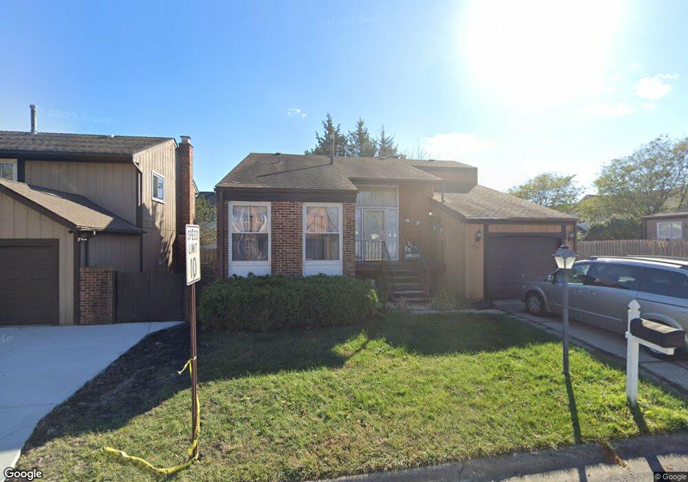
1033 Bob o Link Dr Darien, IL 60561
Estimated Value: $323,669 - $370,000
3
Beds
2
Baths
1,481
Sq Ft
$239/Sq Ft
Est. Value
About This Home
This home is located at 1033 Bob o Link Dr, Darien, IL 60561 and is currently estimated at $354,167, approximately $239 per square foot. 1033 Bob o Link Dr is a home located in DuPage County with nearby schools including Concord Elementary School, Cass Jr High School, and Hinsdale South High School.
Ownership History
Date
Name
Owned For
Owner Type
Purchase Details
Closed on
Mar 26, 1998
Sold by
Espiritu Elizabeth G
Bought by
Espiritu Elizabeth G and Espiritu Maria Christina G
Current Estimated Value
Home Financials for this Owner
Home Financials are based on the most recent Mortgage that was taken out on this home.
Original Mortgage
$112,000
Interest Rate
7.09%
Mortgage Type
Purchase Money Mortgage
Create a Home Valuation Report for This Property
The Home Valuation Report is an in-depth analysis detailing your home's value as well as a comparison with similar homes in the area
Home Values in the Area
Average Home Value in this Area
Purchase History
| Date | Buyer | Sale Price | Title Company |
|---|---|---|---|
| Espiritu Elizabeth G | -- | -- |
Source: Public Records
Mortgage History
| Date | Status | Borrower | Loan Amount |
|---|---|---|---|
| Closed | Espiritu Elizabeth G | $112,000 |
Source: Public Records
Tax History
| Year | Tax Paid | Tax Assessment Tax Assessment Total Assessment is a certain percentage of the fair market value that is determined by local assessors to be the total taxable value of land and additions on the property. | Land | Improvement |
|---|---|---|---|---|
| 2024 | $4,545 | $86,360 | $21,647 | $64,713 |
| 2023 | $4,311 | $79,390 | $19,900 | $59,490 |
| 2022 | $3,895 | $68,970 | $17,290 | $51,680 |
| 2021 | $3,598 | $68,180 | $17,090 | $51,090 |
| 2020 | $3,536 | $66,830 | $16,750 | $50,080 |
| 2019 | $3,394 | $64,120 | $16,070 | $48,050 |
| 2018 | $2,930 | $58,020 | $14,540 | $43,480 |
| 2017 | $2,877 | $55,830 | $13,990 | $41,840 |
| 2016 | $2,770 | $53,280 | $13,350 | $39,930 |
| 2015 | $2,681 | $50,130 | $12,560 | $37,570 |
| 2014 | $2,793 | $51,300 | $12,850 | $38,450 |
| 2013 | $2,683 | $51,060 | $12,790 | $38,270 |
Source: Public Records
Map
Nearby Homes
- 8167 Ripple Ridge Unit 8167
- 8321 Ripple Ridge
- 17W484 Earl Ct
- 1390 Marco Ct
- Lot 1, 2, 3, 4 & 5 Nantucket Dr
- 8338 Portsmouth Dr Unit B
- 8334 Portsmouth Dr Unit C
- 1321 Iroquois Ln
- 709 79th St Unit 408
- 425 79th St
- 7945 Stewart Dr
- 1501 Darien Lake Dr Unit A201
- 7725 Sawyer Rd
- 7700 Apple Tree Ln
- 7525 Nantucket Dr Unit 210
- 714 Walnut Dr Unit 405
- 714 Walnut Dr Unit 205
- 8005 Wildwood Ln
- 7510 Farmingdale Dr Unit 407
- 8405 Carriage Green Dr Unit 2
- 1029 Bob o Link Dr
- 1037 Bob o Link Dr
- 1025 Bob o Link Dr
- 1034 Bob o Link Dr
- 1030 Bob o Link Dr Unit 3
- 1021 Bob o Link Dr
- 8210 Hinswood Dr
- 1041 Bob o Link Dr
- 1026 Bob o Link Dr
- 1033 Meadowlark Ln
- 8206 Hinswood Dr
- 1022 Bob o Link Dr
- 1029 Meadowlark Ln
- 1017 Bob o Link Dr
- 1045 Bob o Link Dr
- 8209 Park Crest Dr
- 1025 Meadowlark Ln
- 8142 Hinswood Dr
- 8205 Park Crest Dr
- 1018 Bob o Link Dr
Your Personal Tour Guide
Ask me questions while you tour the home.