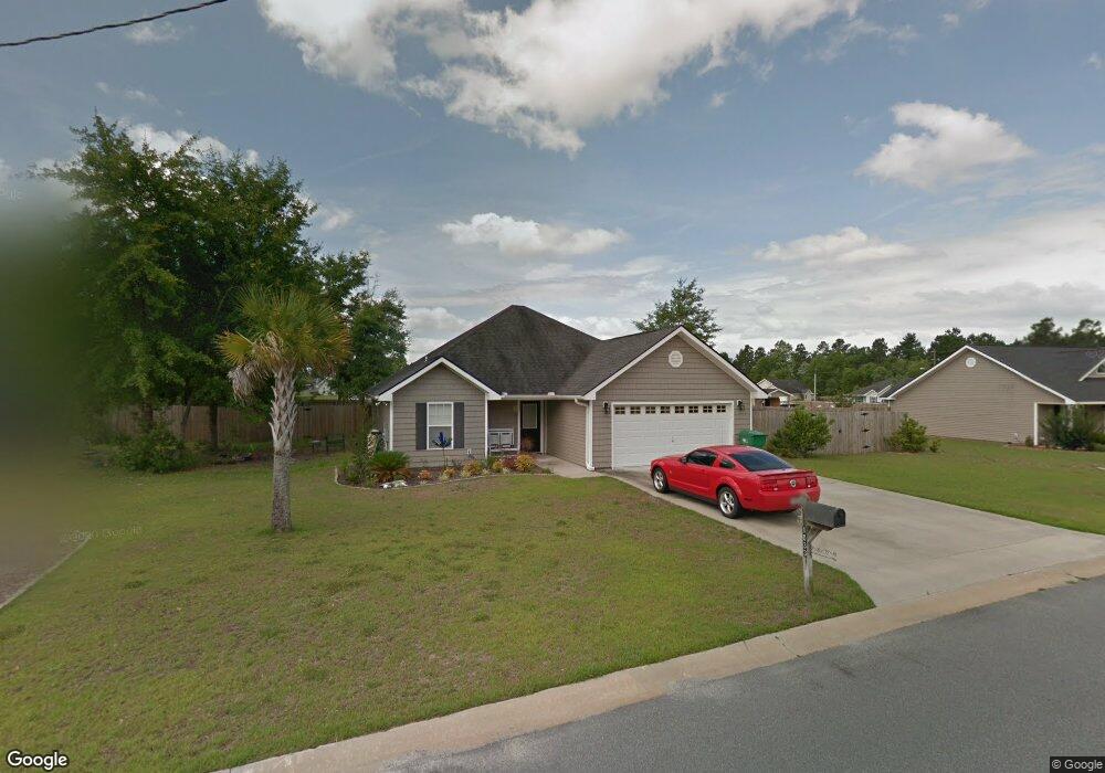
1033 Chart Ln SE Townsend, GA 31331
Estimated Value: $257,077 - $281,000
3
Beds
2
Baths
1,456
Sq Ft
$185/Sq Ft
Est. Value
About This Home
This home is located at 1033 Chart Ln SE, Townsend, GA 31331 and is currently estimated at $269,769, approximately $185 per square foot. 1033 Chart Ln SE is a home located in McIntosh County with nearby schools including Todd Grant Elementary School, McIntosh County Middle School, and McIntosh County Academy.
Ownership History
Date
Name
Owned For
Owner Type
Purchase Details
Closed on
Dec 19, 2005
Sold by
Colonial Coast Development Co
Bought by
Steele Sean Victor and Steele Janice
Current Estimated Value
Home Financials for this Owner
Home Financials are based on the most recent Mortgage that was taken out on this home.
Original Mortgage
$97,524
Outstanding Balance
$54,533
Interest Rate
6.28%
Mortgage Type
New Conventional
Estimated Equity
$215,236
Purchase Details
Closed on
Dec 14, 2005
Sold by
Colonial Coast Development
Bought by
Steele Sean Victor and Steele Janice
Home Financials for this Owner
Home Financials are based on the most recent Mortgage that was taken out on this home.
Original Mortgage
$97,524
Outstanding Balance
$54,533
Interest Rate
6.28%
Mortgage Type
New Conventional
Estimated Equity
$215,236
Create a Home Valuation Report for This Property
The Home Valuation Report is an in-depth analysis detailing your home's value as well as a comparison with similar homes in the area
Home Values in the Area
Average Home Value in this Area
Purchase History
| Date | Buyer | Sale Price | Title Company |
|---|---|---|---|
| Steele Sean Victor | $121,900 | -- | |
| Steele Sean Victor | $121,905 | -- |
Source: Public Records
Mortgage History
| Date | Status | Borrower | Loan Amount |
|---|---|---|---|
| Open | Steele Sean Victor | $97,524 | |
| Closed | Steele Sean Victor | $97,524 | |
| Closed | Steele Sean Victor | $24,381 |
Source: Public Records
Tax History Compared to Growth
Tax History
| Year | Tax Paid | Tax Assessment Tax Assessment Total Assessment is a certain percentage of the fair market value that is determined by local assessors to be the total taxable value of land and additions on the property. | Land | Improvement |
|---|---|---|---|---|
| 2024 | $1,376 | $90,860 | $5,000 | $85,860 |
| 2023 | $1,380 | $86,948 | $5,000 | $81,948 |
| 2022 | $1,380 | $73,592 | $5,000 | $68,592 |
| 2021 | $1,499 | $56,400 | $5,000 | $51,400 |
| 2020 | $1,394 | $52,168 | $5,000 | $47,168 |
| 2019 | $1,312 | $54,552 | $5,000 | $49,552 |
| 2018 | $1,363 | $51,272 | $6,000 | $45,272 |
| 2017 | $1,246 | $41,632 | $6,000 | $35,632 |
| 2016 | $1,048 | $35,712 | $6,000 | $29,712 |
| 2015 | $1,043 | $36,348 | $4,000 | $32,349 |
| 2014 | $1,045 | $36,349 | $4,000 | $32,349 |
Source: Public Records
Map
Nearby Homes
- 1441 Halyard Way SE
- $20,000 PRICE REDUCT Smith Rd SE
- 1155 Merchant Ln SE
- 85 ACRES Catfish Farm Rd SE
- 5096 Smith Rd
- 3261 Smith Rd SE
- 156 AC Us Hwy 17
- 1247 Sapelo Cir SE
- 1155 Sapelo Cir SE
- 1563 Sapelo Cir SE
- Lot 14 Poppell Farms Dr
- 1075 Waters Ct SE
- 18 Doboy Ct
- 0 Carnochan Bluff Unit 10420718
- 1284 Jones Way SE
- 1264 Jones Way SE
- 0 Highway 99 Unit 22514247
- 0 Rice Planter
- 1474 Mcintosh Trail SE
- Lot 21 Sutherland Bluff Dr NE
- 1015 Chart Ln SE
- 1022 Chart Ln SE
- 1046 Chart Ln SE
- 1046 Chart Ln SE
- 1390 Halyard Way SE
- 51 Chart Ln
- 54 Chart Ln
- 53 Chart Ln
- 57 Chart Ln
- 58 Chart Ln
- 1071 Coastal Ln SE
- 1465 Halyard Way SE Unit 59
- 1465 Halyard Way SE
- 1080 Chart Ln SE
- 1368 Halyard Way SE
- 111 Chart Ln
- 1417 Halyard Way SE
- 1070 Coastal Ln SE
- 1395 Halyard Way SE
- 1395 Halyard Way SE