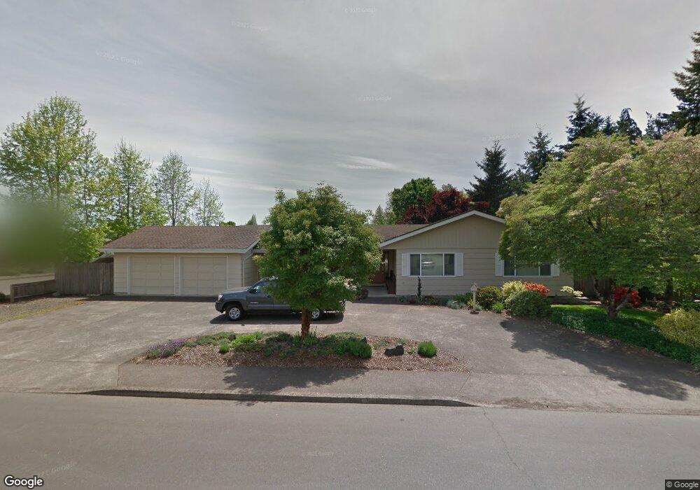
1033 Olive Way E Monmouth, OR 97361
Estimated Value: $528,000 - $589,000
3
Beds
3
Baths
2,495
Sq Ft
$227/Sq Ft
Est. Value
About This Home
This home is located at 1033 Olive Way E, Monmouth, OR 97361 and is currently estimated at $566,452, approximately $227 per square foot. 1033 Olive Way E is a home located in Polk County with nearby schools including Monmouth Elementary School, Talmadge Middle School, and Central High School.
Ownership History
Date
Name
Owned For
Owner Type
Purchase Details
Closed on
Feb 9, 2022
Sold by
Hedberg Jan P
Bought by
Jan P Hedberg And Helen L Hedberg Living Trus and Hedb Helen
Current Estimated Value
Purchase Details
Closed on
Aug 2, 2010
Sold by
Herbert Jacob F and Herbert Trudy M
Bought by
Hedberg Jan P and Hedberg Helen L
Home Financials for this Owner
Home Financials are based on the most recent Mortgage that was taken out on this home.
Original Mortgage
$133,250
Interest Rate
4.65%
Mortgage Type
New Conventional
Create a Home Valuation Report for This Property
The Home Valuation Report is an in-depth analysis detailing your home's value as well as a comparison with similar homes in the area
Home Values in the Area
Average Home Value in this Area
Purchase History
| Date | Buyer | Sale Price | Title Company |
|---|---|---|---|
| Jan P Hedberg And Helen L Hedberg Living Trus | $106,000 | None Listed On Document | |
| Hedberg Jan P | $266,500 | Ticor Title |
Source: Public Records
Mortgage History
| Date | Status | Borrower | Loan Amount |
|---|---|---|---|
| Previous Owner | Hedberg Jan P | $133,250 |
Source: Public Records
Tax History Compared to Growth
Tax History
| Year | Tax Paid | Tax Assessment Tax Assessment Total Assessment is a certain percentage of the fair market value that is determined by local assessors to be the total taxable value of land and additions on the property. | Land | Improvement |
|---|---|---|---|---|
| 2025 | $4,829 | $291,090 | $72,150 | $218,940 |
| 2024 | $4,829 | $282,620 | $70,050 | $212,570 |
| 2023 | $5,028 | $274,390 | $68,010 | $206,380 |
| 2022 | $4,527 | $266,400 | $66,030 | $200,370 |
| 2021 | $4,475 | $258,650 | $64,100 | $194,550 |
| 2020 | $4,298 | $251,120 | $62,230 | $188,890 |
| 2019 | $4,173 | $243,810 | $60,420 | $183,390 |
| 2018 | $4,057 | $238,330 | $58,660 | $179,670 |
| 2017 | $4,034 | $231,390 | $56,950 | $174,440 |
| 2016 | $4,120 | $224,660 | $55,300 | $169,360 |
| 2015 | $3,939 | $218,120 | $53,690 | $164,430 |
| 2014 | $3,851 | $211,770 | $52,130 | $159,640 |
Source: Public Records
Map
Nearby Homes
- 1328 Alberta Ave E
- 751 Catron St N
- 1329 Price Ln E
- 952 Main St E
- 141 S 17th St Unit 61 St
- 141 S 17th St Unit 70 St
- 141 17th (#7) St S Unit 7
- 9650 Hoffman Rd
- 151 Edwards (#146) Rd S Unit 146
- 145 Ecols St N
- Lot 1600 S 16th St
- 590 N Gun Club 585 N 16 St Rd
- 191 Catron St S
- 348 Main St E
- 277 Edwards Rd S Unit 145
- 277 Edwards Rd S Unit 133
- 355 Jacobson Ct S
- 406 Madrona (-408) St E
- 1370 Bentley St E
- 271 Clay St E
- 756 Kayla Way N
- 793 Caroline Way N
- 763 Caroline Way N
- 787 Kayla Way N
- 1030 Olive Way E
- 748 Kayla Way N
- 799 Kayla Way N
- 1000 Olive Way E
- 733 Caroline Way N
- 1163 Lori Ln E
- 1198 Lori Ln E
- 792 Caroline Way N
- 1181 Lori Ln E
- 703 Caroline Way N
- 762 Caroline Way N
- 1210 Lori Ln E
- 1160 Mickey Ln E
- 932 Olive Way E
- 698 Kayla Way N
- 1209 Lori Ln E