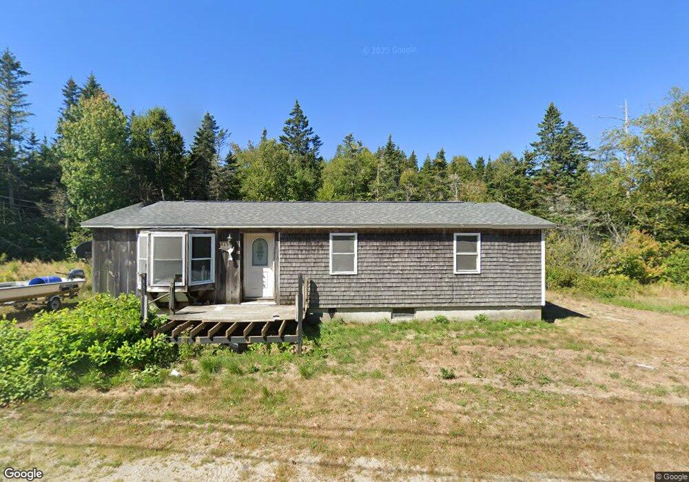
1033 Port Rd MacHiasport, ME 04655
Estimated Value: $38,000 - $135,000
3
Beds
1
Bath
1,056
Sq Ft
$78/Sq Ft
Est. Value
About This Home
This home is located at 1033 Port Rd, MacHiasport, ME 04655 and is currently estimated at $82,626, approximately $78 per square foot. 1033 Port Rd is a home with nearby schools including Fort O'Brien School.
Ownership History
Date
Name
Owned For
Owner Type
Purchase Details
Closed on
Jun 9, 2025
Sold by
Boynton Robert L and Boynton Amanda F
Bought by
Berthiaume Edward
Current Estimated Value
Purchase Details
Closed on
Jan 26, 2018
Sold by
Boynton Amanda
Bought by
Boynton Amanda and Farnsworth Justin
Purchase Details
Closed on
Jul 17, 2007
Sold by
Murphy Michael and Murphy Traci
Bought by
Boynton Robert L and Boynton Amanda F
Home Financials for this Owner
Home Financials are based on the most recent Mortgage that was taken out on this home.
Original Mortgage
$51,592
Interest Rate
6.48%
Mortgage Type
FHA
Create a Home Valuation Report for This Property
The Home Valuation Report is an in-depth analysis detailing your home's value as well as a comparison with similar homes in the area
Home Values in the Area
Average Home Value in this Area
Purchase History
| Date | Buyer | Sale Price | Title Company |
|---|---|---|---|
| Berthiaume Edward | $35,000 | None Available | |
| Berthiaume Edward | $35,000 | None Available | |
| Berthiaume Edward | $35,000 | None Available | |
| Boynton Amanda | -- | -- | |
| Boynton Amanda | -- | -- | |
| Boynton Robert L | -- | -- | |
| Boynton Robert L | -- | -- | |
| Boynton Robert L | -- | -- |
Source: Public Records
Mortgage History
| Date | Status | Borrower | Loan Amount |
|---|---|---|---|
| Previous Owner | Boynton Robert L | $51,592 |
Source: Public Records
Tax History Compared to Growth
Tax History
| Year | Tax Paid | Tax Assessment Tax Assessment Total Assessment is a certain percentage of the fair market value that is determined by local assessors to be the total taxable value of land and additions on the property. | Land | Improvement |
|---|---|---|---|---|
| 2024 | $819 | $62,990 | $17,470 | $45,520 |
| 2023 | $748 | $59,360 | $16,020 | $43,340 |
| 2022 | $702 | $57,060 | $15,290 | $41,770 |
| 2021 | $622 | $57,060 | $15,290 | $41,770 |
| 2020 | $713 | $57,060 | $15,290 | $41,770 |
| 2019 | $1,025 | $59,589 | $12,398 | $47,191 |
| 2018 | $1,102 | $59,589 | $12,398 | $47,191 |
| 2017 | $1,043 | $59,589 | $12,398 | $47,191 |
| 2016 | $1,043 | $59,589 | $12,398 | $47,191 |
| 2015 | $1,085 | $59,589 | $12,398 | $47,191 |
| 2014 | $1,085 | $59,589 | $12,398 | $47,191 |
| 2013 | $1,079 | $59,589 | $12,398 | $47,191 |
Source: Public Records
Map
Nearby Homes
- Lot 1 Smalls Point Rd
- Lot 2 Smalls Point Rd
- 1323 Port Rd
- 1 Puffins Ln
- MarkayEast Puffins Ln
- 576 Port Rd
- 246 Marsh Stream Ln
- Lot2A-2 Holway Rd
- 2-2A-001-A Holway Point Rd
- 18 Collins Cove Rd
- 37 Corn Hill Rd
- 4-28 Old Town Rd Old County Rd Rd
- Lot 95 N Duck Cove Rd
- 0 Port Rd Unit 25695685
- 0 Port Rd Unit 1644648
- 85 E Side Rd
- 604 Duck Cove Rd
- 408 Duck Cove Rd
- 780 Cutler Rd
- 070 Bobcat Path
- 1042 Port Rd
- 1021 Port Rd
- 1017 Port Rd
- 1002 Port Rd
- 1005 Port Rd
- 999 Port Rd
- M21L46 Port Rd
- 8 Sprague Rd
- Lot #6 Indian Head Rd
- 991 Port Rd
- 7 Sprague Rd
- 985 Port Rd
- 984 Port Rd
- Lot 3N Indian Cove Rd
- Lot 3S Indian Cove Rd
- Lot 3 Indian Cove
- Lot 3 Indian Cove Rd
- 977 Port Rd
- 24 Sprague Rd
- 6 Larrabee Cove Rd